Work Week Outlook: 1/31- 2/4
Warming and rainy week ahead, with it turning cold at the end of the week post front. Watching Texas for a significant ice storm.
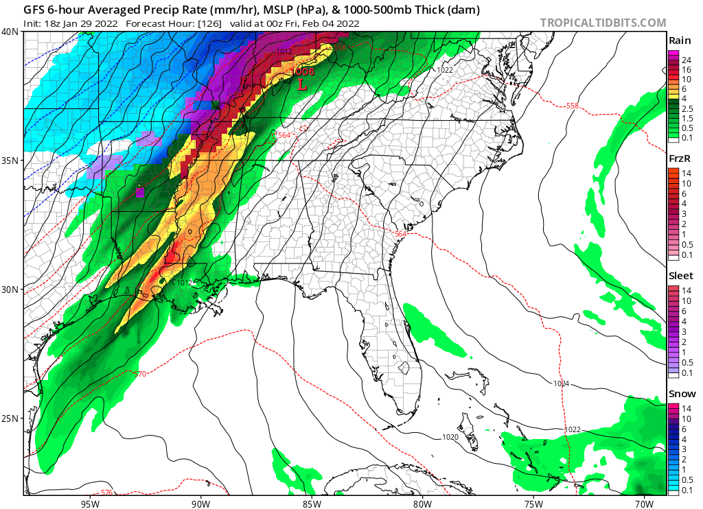
Image Source: Tropical Tidbits. Tropical Tidbits – 1/29/22 18z GFS run for Thursday afternoon showing rain with an approaching cold front.
The thoughts here are my alone. Consult your local NWS for information about hazards and warnings in your particular location.
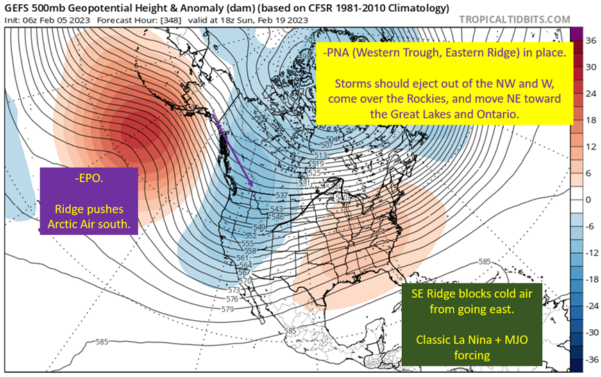
First, let’s take a look at the big picture. The main features I’m looking at are:
1. Alaskan Ridge that will have NW flow out of the Yukon and Western Canada, setting up for cold air to dive into the southeast late week with rain and potentially frozen precip for the Mid-South
2. Troughing up in Greenland, showing a path NE for the late week storm and suggesting we see little more than your typical early February cold front. This look (-NAO) is not good for keeping cold air in the Southeast for very long.
Then there is a small disturbance over Texas to start the period, which looks like will dive too far south into the Gulf for widespread rain chances but wouldn’t be a surprise if some light rain hung over the regions right along the coast Monday night into Tuesday.
Much more significant will be the late week system diving out of the Northern Rockies. This should produce a snow storm for western Texas, ice storm for northern Texas, and potentially significant winter weather up into Arkansas and the Mid-South. This will just be a rain event for us along the Gulf Coast.
Image: Tropical Tidbits. Annotations by Jacob Caddell.
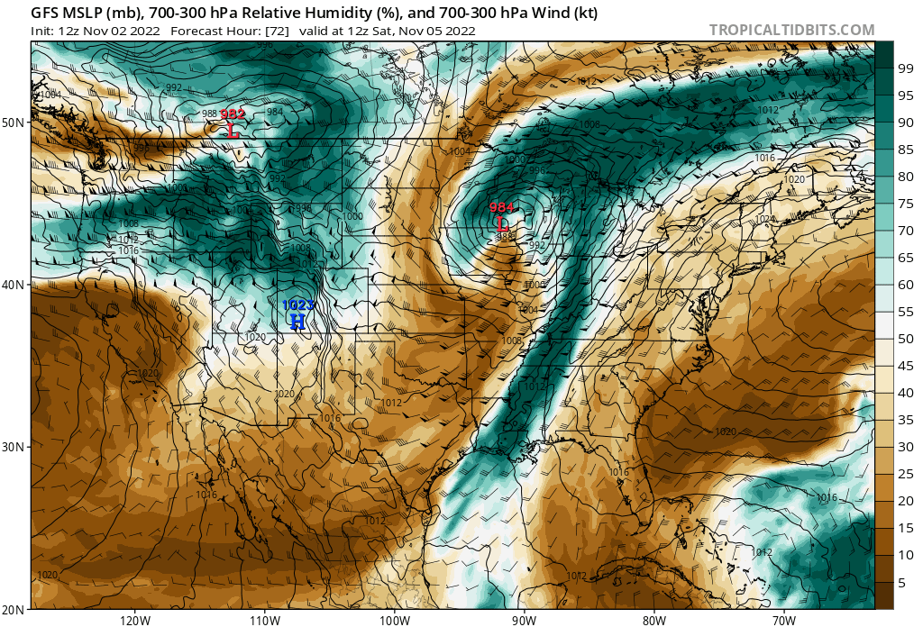
Tuesday Rain? : Models differ, with some showing very little rain for the northern Gulf Coast Tuesday and others presenting an 1″+ across the I-10 corridor from Lake Charles to the Panhandle. Low confidence forecast at this point.
GFS keeps the rain mostly offshore Tuesday and the European still brings some light rain over Louisiana. Current thinking is 50% chance of rain in the Greater New Orleans region Tuesday. Looking east, thinking 20-25% chance of rain over by Mobile and 40% as you hit the Northshore and follow I-10/I-12 west. Image below is from model runs Thursday 1/27, but are representative of the split between the two models currently and I’m just lazy enough not to update.


Images Sourced From: Tropical Tidbits
Image Source: Tropical Tidbits. Annotations by Jacob Caddell.
Temperatures are going to rise through the middle of the week, as winds from the south at the low levels push Gulf of Mexico heat and moisture north ahead of the storm system that will be dropping out of the Rockies mid-week. Temperatures should easily reach the mid 70s by Wednesday, even with persistent cloud cover and likely showers developing through the day, especially over south Louisiana. The rain for Mobile and the Panhandle probably does not get started until the big Thursday storm system arries.
Selection of NWS Model Blend highs for Wednesday 2/2:
Baton Rouge: 72
New Orleans: 71
Lafayette: 75
Biloxi: 66
Mobile: 68
It is also notable the NWS offices in Slidell and Mobile are going a couple of degrees warmer than that across the board. So if anything, expect it warmer than the temperatures listed above with mid 70s likely across south Louisiana.
Images from Tropical Tidbits. Annotations by Jacob Caddell.
This will be a rainmaker for the Northern Gulf Coast, with a significant ice event looking likely for most of Texas, especially the northern half of the state. The current expectation is widespread 1” totals across all of the Northern Gulf Coast, with potential to push 2”. Again, this is Thursday into Friday.
Additionally, I am watching for a conditional severe weather risk across the region as well. There will be abundant shear available for storms but meager instability likely keeps a lid on it. It would be Thursday if it happens. At this point, just be aware it could be a thing but it wouldn’t be surprising at all if nothing severe materializes. Additionally, any severe weather should come with the squall line as the front arrives. One consideration against anything more than isolated severe impacts is that the upper level energy is going to be racing off to the NE, bringing the surface low out rapidly to the NE as well. Squall line should decay rapidly as this happens into Friday, at least in our region.
Temperatures will be lower on Thursday, thanks to the rainfall but should easily get into the upper 60s across the area. That is, until the cold front blasts through late in the day Thursday.
Temps will get near freezing on the Northshore/Baton Rouge and colder as you go west into Thursday night. Southshore will be more on the order of mid to upper 30s, but a steady N to NW breeze will drop wind chills below freezing across the region on Friday morning. Keep those jackets handy, because temperatures will struggle to get out of the lower 40s Friday.
1/29 12z GFS for Friday at noon, depicting temperatures struggling to break the 40s across the region through the day.
Image Source: Tropical Tidbits
The Short Version: Warming through Wednesday, with rain expected Tuesday – Thursday. Watching some conditional severe potential Thursday as well before a cold front passes and temperatures drop into the 40s for highs on Friday with cloud cover to remain most of the day.


