Carnival Season Forecast

A beautiful first weekend of parades upcoming, with a week of transitional weather to follow. Warm start to things on Wednesday, stormy Thursday/Friday, cooling off into Super Weekend. Rain chances will diminish for Super Weekend but return for Lundi Gras and Mardi Gras.
Image Sourced From Tropical Tidbits. This map shows the GFS Ensemble forecasted temperature anomolies spanning from Thursday 2/24 – Mardi Gras.
The big picture here is cooler than normal temperatures for most of the last weekend of Carnival Season. It will be warm Wednesday and Thursday though, with highs approaching 80. That will swing back to highs in the 60s following a cold front coming with a storm system next Thursday (2/24). I like the signal but there’s a good chance this ends up being more of a swinging temp situation with cold fronts followed with quick warm ups and another round of rain and a cold front.
The GFS and Euro are differing out in the Super Weekend range though, but with an active subtropical jet along with the active pattern out west I think multiple rounds of rain and temperature swings are probably in the cards.
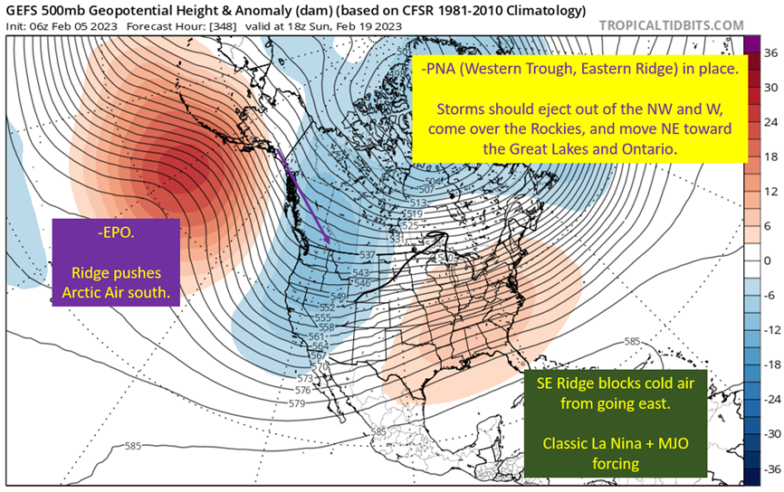
Taking a look at the 500 mb pattern:
Image From Tropical Tidbits. This shows the 18z GFS on 2/16 showing 500 mb heights. Red is warm, blue is cold, and that SW to NE flow generally will induce lift and the formation of low pressures. They should follow the recent trend of forming in Texas and quickly running NE into Rust Belt.
This will certainly be true for the Thursday storm system, with it warming up thanks to the mass response from the forming low pressure bringing flow out of the Gulf. There will be a severe threat with this, but it doesn’t appear to be a widespread one at this time and likely will have the severe threat centered further north. More on that in a later post.
Then comes Super Weekend into Lundi/Mardi Gras. At this point, models are in general agreement of a cold front coming through Thursday/Friday and then a dry and cool Saturday and likely a cool and dry Sunday as well. The next rain chances, after Thursday, would be on Lundi Gras as another system potentially comes out of Texas and brings rain to the area, but it would still be cool outside at least.
Image From Tropical Tidbits, showing 250 mb (upper level/jet stream) flow from the 18z GFS Ensemble from 2/16. With the southern branch of the jet being active, along with positioning of the highest jet stream speeds (jet max) puts east Texas, Louisiana, Mississippi and Arkansas a favored region for lows to form and bring rain to the region.
This is the reason I buy another system coming through before Mardi Gras or even on Mardi Gras day. Generally going to be positioned near the right entrance of the jet stream and that leads to low formation, especially if the bit of energy that should linger near the four corners region over the weekend finally spits out to the east. Plenty of synoptic lift to produce a surface low pressure and rainfall. Thinking Proteus and Orpheus end up with rain this year, though not expecting a washout. Will yield a sloppy Mardi Gras day on the Neutral Ground Side.
In summary:
First weekend should have beautiful weather. Friday will be chilly, with highs in the mid 50s and a nice north breeze. Saturday and Sunday will be a little warmer, getting into that perfect temperature band of low 60s with not a lot of humidity. Glad we’ll be outside to enjoy some of the best weather Louisiana offers.
Now for the weekday parades next week, the start is going to be warm (potentially hitting 80 on Wednesday) and have a chance of rain. A lot like this week really.
Thursday for Muses, expecting an active and warm/humid weather day. Highs getting into the upper 70s and rain coming through with a cold front to follow. Could possibly see a cancellation of parades that day. So be prepared for that.
Friday will start with frontal passage and temperatures will fall through the day. Thinking the highs will be in the upper 50s to low 60s range, with a north wind making it pretty chilly on the route Friday night.
Saturday and Sunday look beautiful at this point for Endymion (MOTs if you’re over in Mobile) and Bacchus (Joe Cain Day for my Mobile people), with clouds likely increasing on Sunday but still temps sitting in the 60s and most likely dry.
Lundi Gras is looking rainy but at least not that warm, but uncertainty is getting pretty high in this range.
Same for Mardi Gras in terms of the uncertainty. May have some rain early and should be cool but if the Monday system is just a little slower, it’ll be a rainy Mardi Gras day.
Will be back after the weekend of parades to have a more detailed preview of each big parade day. Look out for that post on Monday.
Want to support the Gumbo Weather Project? Find me on Patreon at GumboWx’s Patreon


