
Severe Threat: Mobile and Coastal Mississippi Tonight (3/8)
Slight Risk (2/5) of severe storms along the central Gulf Coast tonight as warm front advances over the region ahead of disturbance. Near the warm front will have the strongest shear and warm moist air to give a little instability, so if there are to be severe storms I’d expect them near there.

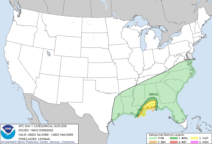
Image From The Storm Prediction Center’s Day 1 Categorical Outlook for tonight. Mobile, Pensacola, and the Mississippi coast get the slight risk. New Orleans is just marginal (1/5).

3/8/22 18z Surface Analysis from the Weather Prediction Center (WPC). The low pressure currently off the south Texas coast will move NE this evening over Louisiana and into Mississippi and Alabama. This will bring the front, currently stalled off the northern Gulf Coast, northward as a warm front overnight before being swept away by a trailing cold front.

The 3/8/22 19z HRRR, valid for midnight tonight. Where the green colors are is effectively the warm front, with low level shear maximized near the front. HRRR soundings show a healthy ~30 kt of shear from the surface to 1 km above the ground. Convection won’t be surface based until the cold front approaches, as seen by the elevated instability on the HRRR sounding shown below.
Basically the warm front loads up warmer air at the surface to allow for a warm layer that will be lifted by the approaching cold front. Shear will be strong, especially in the low levels, so these storms will have to be watched for tornadoes. Additionally, looking at the sounding, there’s cool air aloft that will provide 1000+ J/kg elevated CAPE. So enough to present a severe threat from the far southeast Louisiana coast all the way to the Panhandle.

Image from Pivotal Weather. Using the 19z HRRR, positioned near Pascagoula, MS valid midnight tonight. Decent lapse rates (how quickly the air cools with height) above the surface but pretty anemic at the surface, where the best shear is. So maybe things don’t line up right for tornadoes (though I would stay aware there is still potential), but wouldn’t be surprised to see a few severe warnings for wind and hail with instability available in the sub-freezing zone aloft and that dry slot from about 850 mb to around 500 mb providing ~600 J/kg downdraft CAPE.
The main takeaway is be weather aware tonight, and despite not having the most impressive instability or dynamics, there’s plenty enough shear in the low levels to cause problems and tornadoes do like to form along and near frontal boundaries. Even with no tornadoes, storms should produce strong gusty winds and potentially some hail with those cool mid-levels.
Follow your local NWS office for the most current info in your area and have a way to receive warnings overnight.
That’s all for today.
Related Posts

Hurricane Season 2023 Preview: El Nino Returns

Gulf Low Will Bring Rain and Coastal Flooding

One For The Mardi Gras Skiers

Bust Out The Shorts For Mardi Gras

Hope You’ve Enjoyed Fall So Far. Looking Ahead At The Big Picture Into November.

The Media Coverage Of Ian Has Been Frustrating

Hurricane Ian To Make Second Landfall In Carolinas

Hurricane Ian Strengthens and Grows Larger With Landfall Tomorrow

NHC Forecasting Near Nightmare Scenario For Tampa
