
Severe Weather (Again): Thursday Night
East Texas through southeastern Louisiana at risk Thursday night into Friday. Mississippi coast through the Panhandle gets into the action on Friday.
Severe season continues with Thursday night and Friday morning looking a lot more interesting. I currently think the main risk is going to be gusty winds in thunderstorms. Large hail is also a concern, with steep lapse rates and instability through the hail growth region. The tornado risk looks limited, but not impossible, as the convection should remain elevated for most of the state of Louisiana into Mississippi. The fly in the ointment for tornadoes is realized early on Friday morning, as it looks like there will be enough instability at the surface to get surface based storms. With the shear available, this brings a tornado risk for the Florida Parishes and the Southshore.
On Friday, the dynamics start to fade over the northern Gulf Coast but instability will be present for surface based storms.
Big picture, on Thursday a strong shortwave will come east out of the southern Rockies. As it moves out of the mountains, a surface low will form on the lee side (east side) of the Rockies and track east along with it.

Image made using the gif maker at Tropical Tidbits. This shows the 18z GFS from 3/15, looking at the 700 mb cyclonic vorticity (spin that helps make lift). This has been increasing in strength on the models in the last day or so, and is why there is now some concern for severe weather Thursday night.
As this approaches Arkansas, there will be an increase in the low-level winds and these will transport moist (60+ dew points) air into eastern Texas, and Louisiana from the western Gulf of Mexico. This will provide instability aloft to fire off elevated thunderstorms with potential for large hail and damaging winds.

Image from pivotalweather.com. Annotations by Jacob Caddell. This shows the 850 mb (low-level) winds from the 3km NAM run at 00z on 3/16.
Low levels juice the rest of the column, and with steep lapse rates (over 7 C/km) for this part of the world, you get a decent amount (1000 J/kg) MUCAPE for those elevated thunderstorms to work with. In addition, there will be enough shear through the column to provide for organization of these elevated updrafts and potential for them to rotate.


Both images taken from pivotalweather.com with annotations by Jacob Caddell. This is just to show where those lapse rates and shear will be setting up.
I do want to discuss the tornado threat. It does appear to be dampen by the elevation nature of the storms but the low-level dynamics are absolutely rocking with a strengthening veering wind from the surface. The hodograph from FV3 sounding looks like absolutely trouble in the bottom 3km, where convection won’t really be working through. This is why I doubt many tornadoes spin up on Thursday even with the face ripping 305 0-1 km Storm Relative Helicity.
The thing is, as we get closer to sunrise and the warm air keeps getting pushed into southern Louisiana, there will be a window for tornado potential.

Image from pivotalweather.com. Annotations by Jacob Caddell. This is for around Baton Rouge at around 4 am.
This is one model, and a convective allowing at that. This is just to give an idea of the potential that is there.
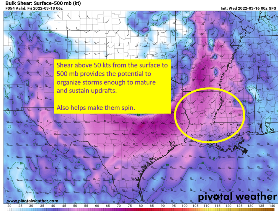
The final thing to look at is the increase in tornado risk by Friday morning across southeastern Louisiana. With the strong low level flow, dew points will be pushed into the mid to upper 60s and this provides enough heat to provide low level instability. With the powerful low level shear available, this provides for a tornado risk across the area circled below.

Image from pivotalweather.com, with annotations by Jacob Caddell.
What is happening to drive up the surface based instability? A warm front should lift out of the Gulf of Mexico and drape its self roughly along I10 in southeastern Louisiana. This is why the SPC is starting to highlight a tornado risk down in the circled area. For the rest of the state though, the tornado risk looks minimal with the elevated nature of the convection. This will be an early morning event in southern Louisiana, so you definitely want a way to receive warnings and maybe hold the commute back if you can.
The takeaway? High winds in storms is the most likely severe impact from this, with large hail also possible. There will be a window for tornado potential before and around sunrise, so have a way to receive warnings especially if you’re east of the 10/12 split.
That’s all for today. Tomorrow I’ll do a look over what all the convective allowing models are showing, and check how they measure up to observations.
Related Posts

Hurricane Season 2023 Preview: El Nino Returns

Gulf Low Will Bring Rain and Coastal Flooding

One For The Mardi Gras Skiers

Bust Out The Shorts For Mardi Gras

Hope You’ve Enjoyed Fall So Far. Looking Ahead At The Big Picture Into November.

The Media Coverage Of Ian Has Been Frustrating

Hurricane Ian To Make Second Landfall In Carolinas

Hurricane Ian Strengthens and Grows Larger With Landfall Tomorrow

NHC Forecasting Near Nightmare Scenario For Tampa
