
Potent Severe Threat Early In The Week
Spring is here, and with it comes the heart of severe season. On Monday, eastern Texas and western Louisiana get into the action as a strong longwave trough beings to move east out of the western United States. Strong kinematics and surge of warm air into eastern parts of Texas and into western Louisiana set the stage for all modes of severe weather. The SPC already has an Enhanced Risk (3/5) for Day 2. This system will continue east into Tuesday and Tuesday evening, bringing a very potent severe threat somewhere from southern Louisiana to northern Mississippi. The SPC has a Moderate Risk (4/5) out already at Day 3, indicating a threat for a substantial severe weather outbreak.
Right now, still trying to figure out exactly how the pattern evolves as that will set the where for the severe risk on Tuesday.
Monday Across Eastern Texas and Western Louisiana
This will be somewhat brief, as the Louisiana/Mississippi end is the focus of this blog.

03/19/22 GFS at 12z, showing equivalent potential temperature (quick and dirty way to get an idea of heat and moisture). Image from pivotalweather.com, with my own annotations.
You get instability starting to build by the afternoon in eastern Texas, as the surface low and upper low being pulling air in from the Gulf of Mexico. There will likely be storms and rain going all morning in the northern parts of Texas into southern Oklahoma. This raises questions into how far north the unstable air will get. Where it does get to will see an increasing tornado threat as the afternoon and evening go on. The dryline will provide a focus for storms further to the west and north, likely yielding some Texas sized hail.
The dynamics in eastern Texas by late Monday afternoon are more than enough to yield tornadoes, as seen from the hodograph below.

Hodograph from the 12z GFS for an area in east Texas, image taken from pivotalweather.com with my own annotations.
Basically, this is what you look for (this general sickle shape) for tornado risk. This, combined with the expected instability, is why the Storm Prediction Center already has an Enhanced Risk (3/5) a couple of days prior to the event.

Storm Prediction Center Day 3 Categorical Outlook, showing where the fine meteorologists at the SPC are expecting the highest severe risk on Monday.
Tuesday and Tuesday Night: Louisiana and Mississippi
Every parameter I look at for tornado threats and general severe weather will be in abundance across southern Louisiana and most of Mississippi. The Day 3 SPC outlook has a moderate (4/5) risk already on the board. This is the region where the current thinking would have the highest risk of tornadoes and severe weather.

Rare Day 3 Moderate Risk (4/5) from Storm Prediction Center. Probabilities are as high as they can be for this far out from the event.
Upper Level Dynamics
The upper level winds are going to be an important player. The subtropical jet will be coming in from the south and the polar jet will round the trough. This leads to them phasing together over the western Gulf Coast. There are difference in how this evolves across the NAM, GFS, Canadian, and European models and those differences have consequences to the severe potential for southern Louisiana and Mississippi.
The reason this matters is upper level divergence leads to surface convergence, and this makes surface low pressures. The closer and stronger a potential surface low is to your area, the more you ramp up the severe risk.
Currently the European is the outlier, having the two jets phase nicely but not showing the upper divergence of winds over the area. So it does not produce much a southern surface low.
Below I’ll show you the differences between the GFS (weaker surface low and further north), NAM (stronger low and further south), and Canadian (stronger still and similar placement to the NAM). I don’t know at this point which one will end up having the closest to the truth. It is though, worth considering the consequences of each.

Image made with images from pivotalweather.com and annotated by Jacob Caddell. Showing upper-level (300 mb) winds and circling areas of divergence.

Image made from images taken from pivotalweather.com and annotated by Jacob Caddell.
This is to give you the general idea of how a surface low might form under and near areas of upper level divergence. Again, I don’t know exactly where this will be (or if the Euro is right and it doesn’t happen like this) but this is to make you aware of the possibilites.
Low Level Dynamics
The result of the surface low placement leads to the placement of the low level jet. This is another piece of what gets storms spinning. Where this maxes out will have winds pushing 70 kt just above the surface and that’s where the highest risk of tornadoes and other severe storms will be, assuming an unstable airmass (which will be there). Take a look below at the differences in where that maximum wind is based on where the surface low pressure is located.

Image made from images taken from pivotalweather.com. This is the 850 mb winds valid at the same time on Tuesday afternoon. Showing this to note the placement and how that potential surface low genesis will lead to differences in where the severe risk is maximized.
Thermodynamics
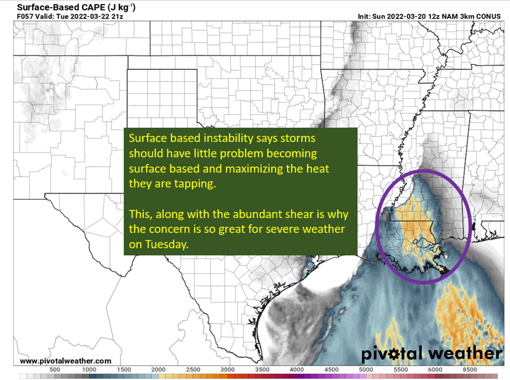
Unlike the late week “event”, return flow from the Gulf of Mexico will be ongoing by Monday. This will allow for a full day or more of warm air to be pushed out of the Gulf and over southern Louisiana and Mississippi and mean storms will be surface based, which means a greater tornado risk.

Image from pivotalweather, showing the 3/20/22 12z High Resolution NAM’s depiction of surface based instability.
It happens because warm air continues to be pushed in ahead of a trailing line of storms associated with a cold front that will be pushing across Louisiana and Mississippi through the day. This allows the low levels and surface to be warm, especially if some sunshine peaks out ahead of any storms. While this is happening, the mid to upper levels begin to cool and cold air is transported in from the west at those levels. You can see this happen below, as the trough approaches heights (which are closely related to temperatures, with lower heights meaning lower temperatures) begin to fall across the region. Warm the low levels, cool the mid to upper levels, and you get buoyancy.

500 mb heights from the 12z GFS on 3/20/22. Gif was made with the forecast gif maker from tropicaltidbits.com.
To sum it up: There will be more than enough instability, abundant shear to organize and rotate updrafts, and upper level forcing to provide additional vertical motion. This is the recipe for a severe weather outbreak. That does not mean it is a certainty, as storms could end up being in a line vs having individual cells running alone. A more linear storm mode keeps the high wind and hail risk very elevated, but takes the high end tornadoes off the table. I will be watching the convective allowing models over the next day to see how they evolve the storms. Do we get the more dangerous discrete cells or more of a linear structure?
At this point, it’s good to be aware of the risk of a significant severe weather outbreak along and south of I20. With that, you should have a plan for what to do if a tornado is threatening. Those in mobile homes should also have a plan for non-tornadic severe storms as straight line winds can still do substantial damage to mobile homes. Have a way to receive warnings all day, and take those warnings seriously.
I’ll be back tomorrow, looking at the nowcast in Texas and checking out the convective allowing models to try and pin down where the highest risk will exist and exactly how the storms will evolve.
Related Posts

Hurricane Season 2023 Preview: El Nino Returns

Gulf Low Will Bring Rain and Coastal Flooding

One For The Mardi Gras Skiers

Bust Out The Shorts For Mardi Gras

Hope You’ve Enjoyed Fall So Far. Looking Ahead At The Big Picture Into November.

The Media Coverage Of Ian Has Been Frustrating

Hurricane Ian To Make Second Landfall In Carolinas

Hurricane Ian Strengthens and Grows Larger With Landfall Tomorrow

NHC Forecasting Near Nightmare Scenario For Tampa
