
Potential Severe Weather Outbreak: Tuesday March 22nd, 2022
All the ingredients for severe storms and tornadoes will be in place tomorrow afternoon and tomorrow evening across Louisiana, Mississippi, and western Alabama. This is the time to have a plan ready if a tornado or severe thunderstorm warning is issued in your area and to make sure you have multiple ways to get warnings tomorrow. My general thinking right now is there will be a strong line of storms push through all of the threat region which will likely have pockets of damaging winds, embedded tornadoes, and some hail. There is also a threat of discrete cells firing ahead of the line, and those will have the maximized risk of tornadoes and large hail.
The individual cells are most likely to start firing along and north of I12, though I can’t rule out some of those firing farther south and west, and mature as they race into southern Mississippi. The area the Storm Prediction Center has as a Moderate risk tomorrow is the area I’m most concerned with the potential for those rouge cells.

SPC Day 2 Categorical Outlook from 1730z on 3/21/22. The moderate risk area has the greatest potential for strong tornadoes and large hail from individual cells forming ahead of the main line of storms.

Water Vapor Satellite, made using the gif maker at tropicaltidbits.com. The main feature to look at is the swirl over in New Mexico. That is the upper trough starting to wind up at the base and will eventually take on a little bit of a negative tilt and that energy lifts to the ENE over the next 24-36 hours. This is the feature that sets the stage for the severe outbreak in our neck of the woods. In response to the lift provided by the upper low, a surface low pressure is forming over the Texas Panhandle and will migrate ENE with the upper low. With ridging and high pressure over the southeastern United States currently, a pressure gradient has built today to drive gusty winds in from the south.
This has lead to forecast offices across Louisiana, Mississippi, and Alabama to put up wind advisories ahead of the storms coming tomorrow. This also serves to push warmer and moist air out of the Gulf of Mexico and up into all the states at risk tomorrow.

The 12z 3km NAM on 3/21/22. Image taken from pivotalweather, showing surface dew points and winds. At this point a healthy fetch of mid 60s dew points are being pushed into eastern Texas and Louisiana. These will spread northward and eastward as the day progresses.
One note closer to the coast, since this air will be blowing over relatively cool Gulf of Mexico shelf waters (it’s only March, the heat hasn’t had a chance to build) it could serve to limit those individual cells from firing. At least around or south of I10. This does not mean they won’t, and again be prepared for the possibility, but this scenario would be of larger concern for that region come April when dew points would be in the 70s and the air even warmer. Again, I’m not saying this WILL lead to no individual cells or take away the higher end severe risk but it is part of the reasoning for the concern to be more or less north of I12 and US190.

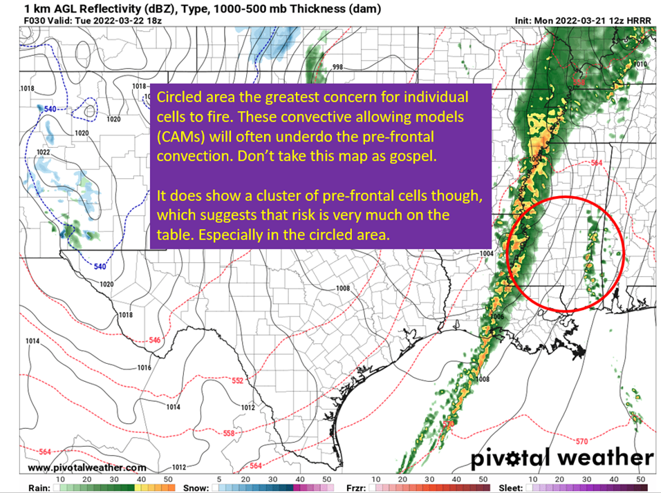
3/21/22 18z HRRR from pivotalweather, showing one solution as to how the convection will evolve. I circled the region where I believe the greatest threat of discrete supercells and tornadoes will roughly be. Looking at the HRRR sounding, all the ingredients are certainly there. Below I show you a point in southern Mississippi, but this is a reasonable representation of the parameters in the region.

Model based sounding, taken from pivotalweather. I noted some of the things that grab my attention here in terms of tornadoes and hail. This is why any prefrontal cells much be watched closely because this has the makings of supercells.
It is possible there is just too much shear and the updrafts will get too tilted and not mature. Again, I’m not saying that WILL happen, just something like that might be a reason storms in front of the line do not mature. With these parameters though, I would not take any chances if those prefrontal storms come my way. It is also worth noting most of the shear is coming from speed differentials with height vs directional differential with height. For widespread severe weather, I’d “like” to see more turning with height but the speed differential is still enough to support all modes of severe weather. This last point was noted in the fantastic LIX Forecast Discussion from this morning.
The Squall Line
The other piece of this will be a vigorous line of storms that comes with the cold front. While these lines can’t maximize these severe parameters to put down violent tornadoes, they present a more widespread risk of damaging straight line winds and EF1-EF2 level embedded tornadoes. The upper, mid, and low level forcing is all going to align over the line of storms, with plenty of instability and shear.

The 12z GFS from 3/21/22, showing the 300 mb level winds. Image from pivotalweather, with annotations by Jacob Caddell.

The 18z NAM from 3/21/22, showing low-level (850 mb winds). Anywhere with those 50 kt winds or more have the potential to have those winds brought to the surface is bowing segments from the development of rear inflow jets. With that treat will also likely come spinning within the line and some short lived by potentially strong tornadoes. I often hear people say it is good when in lines out, because you won’t see much severe weather from it. In this case, a linear mode just takes the high end off the hail and tornado threat but still will have potential for all modes of severe weather.
For those in southern Louisiana, April 27th 2015 was also just a line of storms but one that brought widespread high winds and some tornadoes across the region. I’m not saying it will be a repeat of that, but the dynamics in place for this line are quite strong and severe thunderstorm warnings that it will spring should be taken very seriously.
To summarize: The threat of discrete supercells is the threat that would maximize the parameters and produce large tornadoes and hail. It is not a certainty those will fire, but if they do, they really have very high end potential. The most likely locations for those cells would be along and north of US 190 and I12 and really maturing as they enter Mississippi. Some convective allowing models show those cells forming farther east into western Alabama, and they would provide the same high end threat over there if they do. This is not to say areas south of US 190 won’t have these dangerous prefrontal storms, just that the areas north look far more likely.
Follow that threat will be a strong line of storms that will present a damaging straight line wind, embedded tornado, and hail threat. Once again, the most likely locations for that will be in the moderate risk zone of the SPC chart shown near the top of the post but anywhere in the risk region could see those threats materialize from this line. So stay weather aware tomorrow, have a plan if a tornado threatens your area, and have multiple ways to receive warnings.
I’ll be back tomorrow afternoon for some nowcasting on the event. Stay safe y’all.
Related Posts

Hurricane Season 2023 Preview: El Nino Returns

Gulf Low Will Bring Rain and Coastal Flooding

One For The Mardi Gras Skiers

Bust Out The Shorts For Mardi Gras

Hope You’ve Enjoyed Fall So Far. Looking Ahead At The Big Picture Into November.

The Media Coverage Of Ian Has Been Frustrating

Hurricane Ian To Make Second Landfall In Carolinas

Hurricane Ian Strengthens and Grows Larger With Landfall Tomorrow

NHC Forecasting Near Nightmare Scenario For Tampa
