
Severe Outbreak Potential: Texas And Western Louisiana Today
A significant severe weather outbreak is expected tomorrow over Louisiana and Mississippi. Today, I want to look at how the system is currently evolving over Texas and then I’ll have another post concerning the Louisiana and Mississippi severe potential later on this evening.
So first off, looking at the surface observations in Texas. We have a cold front diving out of the Rockies. A surface low forming in the Panhandle of Texas. In response to the upper low and this forming surface low, winds are picking up out of the south across eastern and central Texas and bringing a warm front out of the Gulf of Mexico with it. There is also a dry line working into central Texas that will provide a spark for severe weather this afternoon in central and eastern Texas.

3/21/22 18z surface observations from the SPC, with me drawing in some of the key features and the directions they’ll be heading.
Next, you can see a large swath of unstable air over the eastern 2/3s of Texas. Surface based CAPE values reaching 2000+ J/kg are more than enough to support vigorous updrafts and severe weather potential.

This shows surface based instability (red contours) and convective inhibition (blue shading). This is simply showing ample instability building across Texas. Next how about the shear available, and there’s plenty:

SPC map showing the bulk shear from 0-6 km. These values over 50 kts are generally conducive to supercell potential.
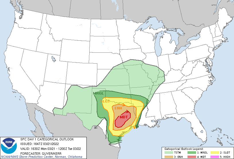
All of this combined, with abundant low level shear is why the Storm Prediction Center upped parts of central and eastern Texas into a Moderate risk (4/5) for today. Within the moderate risk zone is a greater risk for tornadoes, as you’ll see in the images below of the SPC’s Day 1 Categorical Risk product and the tornado probabilities.

SPC Day 1 Categorical Outlook, showing where the highest risk of severe weather exists this afternoon and evening.
Next, is the tornado probabilities with hatching showing an elevated risk of EF2+ tornadoes.

East Central Texas with the bullseye for tornado risk this afternoon and evening.
Looking at the visible satellite loop below, you can see low level clouds streaming south to north out of the Gulf of Mexico. As those enter Texas, you can see higher clouds coming from the west and southwest over them. That’s illustrative of the shear ongoing, with different wind directions and speed with height. You can also see the dryline start to migrate, with a line of clouds out near Abilene, TX and clearing skies behind them.

The short story is all modes of severe weather are possible and even likely across eastern Texas. Dallas FW, Houston, and Austin all have potential for wind, hail, and tornadoes. The worst of it will likely be in between all of those metro areas, where the moderate risk from the SPC is located.
That’s all for this quick look at Texas. Later on today, I dig into Louisiana, Mississippi, and Alabama threats for tomorrow.
Related Posts

Hurricane Season 2023 Preview: El Nino Returns

Gulf Low Will Bring Rain and Coastal Flooding

One For The Mardi Gras Skiers

Bust Out The Shorts For Mardi Gras

Hope You’ve Enjoyed Fall So Far. Looking Ahead At The Big Picture Into November.

The Media Coverage Of Ian Has Been Frustrating

Hurricane Ian To Make Second Landfall In Carolinas

Hurricane Ian Strengthens and Grows Larger With Landfall Tomorrow

NHC Forecasting Near Nightmare Scenario For Tampa
