
The Arabi Tornado Last Night: Quick Case Study
Spent most of the afternoon expecting to post about how the forecast bust yet again for Louisiana and this time southern Mississippi, but that changed about the time I took my family downstairs as an apparent tornado crossed the Mississippi just to our east. Storm survey was done this morning at rated the tornado in Arabi as an EF3, a strong tornado, and the second for the eastern part of the New Orleans metro area since 2017.
The question I’m pondering is why did we have all day of nothing happening in southern Louisiana to a pair of supercells, one that went into St. Tammany and the other that we all watched with horror come through New Orleans East and St. Bernard.

From WDSU coverage of the tornado, showing a multi-vortex tornado with a main parent wedge and a side vort jutting out the side and yes…you can see it.
The Squall Line Broke
This was the first piece that made it possible, as the line of storms that had been pushing slowly through Louisiana all day began to break apart into individual cells. This meant that cells had the opportunity to sustain updrafts without interference from other storms; therefore, they could take advantage of a volatile and spinny atmosphere. That’s just a piece though, since we had cells try to fire all day ahead of the line and mostly fail until much farther north. They did cluster, south to north, those earlier cells and the wind direction was mostly due south near the surface. This would typically mean those cells were eating the cooler outflow of other cells and moving into cooler patches of air and that could have stopped the tornado making processes.
That being said, the two soundings from Slidell yesterday afternoon and evening provide additional clues.

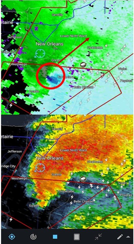
Radar image taken by me, as I was hiding on the first floor of my building. Tornado circled.

The 00z Upper Air Sounding from LIX on 3/23/22. These differences are subtle vs the 18z one sent up in the afternoon. There’s a little more veering (clockwise turn as you go up) with height at the low levels. This helps us get spinning at the lower levels. With the 0-3 km CAPE at 122 J/kg, there’s also plenty of instability for upward acceleration. The ridiculous SRH numbers show this was an environment ripe to get something spinning.
Another thing, pointed out by LIX meteorologist Christopher Bannan on twitter today (@ulmwxr) was there was some low-level divergence through the day over southern Louisiana and that is not conducive to rising air. A good way to think about this is imagine a column of air. The air can enter/exit from the top and bottom. The air coming in must equal the air leaving this column (mass conservation). For storms, you want a bunch of air coming in at the bottom (convergence) and leaving through the top (divergence) which means the air is entering at the bottom and rising to the top.
By 6-7 pm last night, the lower convergence picked up.

Looking at SPC Mesoscale Analysis archive, at 00z last night for surface moisture convergence. This data can be found here
Surface convergence increases, and at the same time the winds pick up in the mid-levels as the main energy from the trough moves closer to the region.

SPC Mesoscale Analysis archive, showing the increase in the 500 mb winds over the New Orleans and a pocket of cooling at that level over the city.
Finally, there was a jet stream split at 300 mb that came overhead just as the mid-level punch came in. This also supports rising air and was also a likely contributor to conditions being right to finally spark tornadic activity.

SPC Mesoscale Analysis archive, showing the upper level divergence that swung over New Orleans as the line broke into individual cells and the mid-level energy increased. All of this together allowed the storm to tap the dangerous atmosphere in place and unfortunately drop a tornado over the New Orleans metro area.
That’s a quick look at some of the factors that led to this tragic outcome.
Good news is the weather should be wonderful through the weekend, before we have another potential severe event again to start the workweek. I’ll preview that in the next few days, and also give an update on things I am working on for the site. Thanks for stopping by Gumbo Weather.
Related Posts

Hurricane Season 2023 Preview: El Nino Returns

Gulf Low Will Bring Rain and Coastal Flooding

One For The Mardi Gras Skiers

Bust Out The Shorts For Mardi Gras

Hope You’ve Enjoyed Fall So Far. Looking Ahead At The Big Picture Into November.

The Media Coverage Of Ian Has Been Frustrating

Hurricane Ian To Make Second Landfall In Carolinas

Hurricane Ian Strengthens and Grows Larger With Landfall Tomorrow

NHC Forecasting Near Nightmare Scenario For Tampa
