
Nowcasting The Severe: Wednesday 3/30
Tornado warnings are starting to pop within the line in Northern Louisiana. Time to take a look at see how it is actually evolving.
First of all, at the surface:

Image from SPC Mesoanalysis Page. Pressure falls ongoing across northern LA as the surface responds to the upper level forcing from the splitting jet stream and incoming trough down at 500 mb. Pressure gradient is tightening ahead of the storms, leading to those well advertised strong gradient winds. In addition, starting to see numerous tornadoes within the line of storms in NW Louisiana currently as the pressure drops start to increase with time.
As I’m writing this, numerous tornado warnings have been issued in western Louisiana.

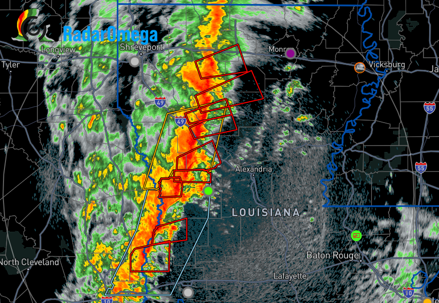
Radar showing this line being a QLCS tornado printing machine. You can see why looking at the 850 mb analysis from the SPC at 16z today below.

Low-level jet is flexing over Louisiana, with winds of 55-60 kt overspreading the entire state. This is helping to goose the low-level shear as the winds are increasing in speed very rapidly with height. The low level jet will push east and start to increase in strength to the north as the day goes on. Meaning the imbedded tornado threat within the line will continue across Louisiana, Mississippi, Alabama, Arkansas, and even in western TN. This is along with the damaging straight-line wind threat this line of storms will provide.
At 500 mb, a punch of stronger winds is also pushing into the area and the jet stream split at 300 mb is providing upper level divergence to also provide some additional forcing for this line of storms to take advantage of.

SPC Mesoanalysis for the 500 mb winds, valid 16z this morning. This push of stronger mid-level winds just increases the dynamics this line has to work with.

SPC Mesoanalysis at the 300 mb level, showing the increase in upper level divergence through the region.
Finally, I want to look at the surface based instability building in Mississippi and southern Louisiana.

Surface based instability building in front of the line. This unfortunately means this already productive line of storms will be moving into even better conditions for severe weather as the day moves on.
Keep an ear out for warnings, and take them seriously today. Still have concerns over the line breaking some along the I10 corridor and into SE Mississippi and SW Alabama later today. There will be soundings at 18z (1 pm) across most of the southeast which will give some insight into how the thermodynamics are evolving. If interesting enough, might be able to squeeze out a quick post later looking at those. If not though, conditions are ripe for a significant outbreak of severe weather across the region this afternoon.
Related Posts

Hurricane Season 2023 Preview: El Nino Returns

Gulf Low Will Bring Rain and Coastal Flooding

One For The Mardi Gras Skiers

Bust Out The Shorts For Mardi Gras

Hope You’ve Enjoyed Fall So Far. Looking Ahead At The Big Picture Into November.

The Media Coverage Of Ian Has Been Frustrating

Hurricane Ian To Make Second Landfall In Carolinas

Hurricane Ian Strengthens and Grows Larger With Landfall Tomorrow

NHC Forecasting Near Nightmare Scenario For Tampa
