
A Busy Early April Ahead
Once again the SPC has a severe risk for next week across the entire southeast over a three day period. This system does not look as potent to me as the last two, but still enough there to warrant some discussion.
Going into the following week, potential is building for yet another significant severe weather outbreak for the United States. I won’t get into details this far out but I will discuss why I think that week has significant severe weather potential.

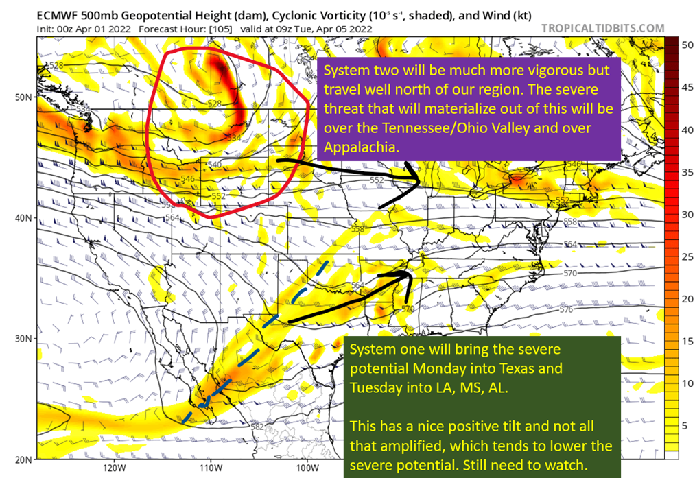
The 00z Euro from 4/1/22, showing 500 mb vorticity. Image from tropicaltidbits, with annotations by Jacob Caddell.
System 1, with the blue dotted line, will translate east and eventually NE from Monday into Tuesday. In response to the forcing from the trough, a surface low will develop (you might have noticed that the right side of a trough spins up surface lows) across Texas and track toward the Ozarks. The usual surge of warm air out of the Gulf of Mexico will begin ahead of it, providing some instability for severe storms. The extent of that instability is still in question, and while there will be a good amount of shear it will not be as strong as the last two weeks provided.
I’ll dig into the specifics of the severe potential this weekend. I do also want to note this system will have potential to drop quite a bit of rain over the southeast. Model soundings show a mostly saturated column of air all the way up to the top of the troposphere. While instability is not impressive, this sort of sounding suggests an increased potential of flash flooding across Louisiana, Mississippi, Alabama, Georgia, and Tennessee. Exactly where the heaviest rain sets up will depend on low pressure track, but this could end up being the bigger story with this system.

The 12z GFS from 4/1/22, showing PWAT (measure of moisture through the entire troposphere) and surface level pressures. Image from tropicaltidbits with annotations from Jacob Caddell.
That’s the early preview for the system next week. Some severe potential present and heavy rain also will be on the table.
Now, onto that second week of April. The jet stream over the Pacific is the harbinger of a likely potent severe threat for somewhere east of the Rockies by that second week in April.

00z European Model from 4/1/22, showing 250 mb (jet stream) winds. Image from tropicaltidbits with annotations from Jacob Caddell.
Like I said, I’m not going to dive into details here but the Pacific jet flexing should end up producing the potential for a severe weather outbreak somewhere over the Plains or Deep South. The subtropical jet is also a little more active, suggesting more potential for a big upper level divergence that provide additional lift. Plus, as we get into the middle of April that warm flow out of the Gulf of Mexico is warmer and with higher dewpoints that help increase the instability.
This is still a long way away to even worry. There’s still a week before it is possible to make decent predictions on how it evolves, so stick a pin in this until then. I just wanted to bring up the potential.
So a short update today, just doing a big picture sweep before diving back into the details into the weekend and early next week. I’m going to be out at Hogs for the Cause tomorrow, getting my BBQ on and hopefully dodging a few scattered showers. Gotta enjoy the pleasant parts of spring weather, because summer is lurking not very far away.
Related Posts

Hurricane Season 2023 Preview: El Nino Returns

Gulf Low Will Bring Rain and Coastal Flooding

One For The Mardi Gras Skiers

Bust Out The Shorts For Mardi Gras

Hope You’ve Enjoyed Fall So Far. Looking Ahead At The Big Picture Into November.

The Media Coverage Of Ian Has Been Frustrating

Hurricane Ian To Make Second Landfall In Carolinas

Hurricane Ian Strengthens and Grows Larger With Landfall Tomorrow

NHC Forecasting Near Nightmare Scenario For Tampa
