
Monday and Tuesday: Digging Into Severe Potential
Differences remain in the modeling, with European and Canadian bringing storms farther south into Louisiana before moving into MS/AL. GFS remains quicker moving things, and keeps south Louisiana mostly dry before sparking storms in MS, AL, GA, and TN. Monday during the day is starting to look wet, but not likely to be producing significant thunderstorms.
All the models suggest another line of storms form over Monday night but again differ on placement. The Euro/Canadian solution would drive it across Louisiana and present severe potential Monday night into Tuesday morning, while the GFS wants to move it across Arkansas and into MS/AL while only draping scattered showers over Louisiana and coastal regions.

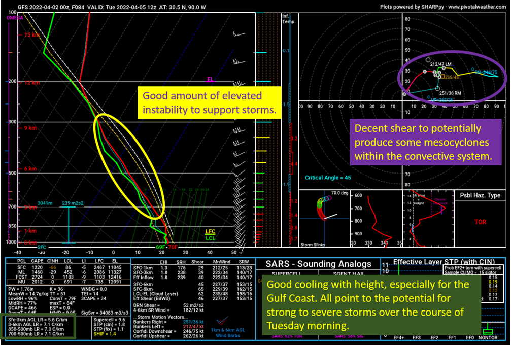
This is a sounding derived off the 12z GFS on 4/2/22, location over the Northshore at 1 am Tuesday morning. Image from pivotalweather, with my typical markups on it.
This shows why there is potential for severe weather on Tuesday morning, possibly overperforming expectations despite the pedestrian synoptic scale features. There should be good cooling with height, on the order of 7 C/km. This creates moderate instability, mostly elevated, over the region to produce updrafts and strong to severe storms. In addition, there is a little bit of backing (clockwise turning of the wind) with height at the low levels to provide some direction shear and the winds increase with height providing decent speed shear.
In other words, the ingredients are there to produce strong to severe storms overnight and into the morning on Tuesday. Strong winds would be the most likely severe impact, with hail possible and even a tornado or two if the instability can get more surface based.
Looking farther north, the instability will be lacking compared to the near coastal regions. This system should still produce some storms, but the severe potential is going to be muted relative to the coast. It is notable the saturated atmospheric profile across Alabama and Georgia going into Tuesday afternoon. It presents the potential for flash flooding within the heaviest rain bands as the rain production should be quite efficient over the those northern regions. The Weather Prediction Center has highlighted eastern Alabama and most of Georgia for a slight chance of excessive rain on Tuesday, with potential for that risk to increase a little bit.

The 12z GFS from 4/2/22, showing the Precipitable Water on Tuesday afternoon. Image from pivotalweather, with annotations by Jacob Caddell.
Last of all, I want to take a look at the model differences on precipitation placement early Tuesday morning. This is to highlight the uncertainty in where the storms will actually set up during the period. I still think coastal regions would get storms, even with the GFS depiction but the Euro and Canadian would obviously be more productive in terms of storms for the coastal regions.

These are the Euro, GFS, and Canadian models showing radar depictions for Tuesday morning at 1 am. Images from pivotalweather.
So questions still remain. By Sunday into Monday, we will have access to the convective allowing models to hopefully clear up these differences and give a little more certainty to the forecast.
That’s all for today.
Related Posts

Hurricane Season 2023 Preview: El Nino Returns

Gulf Low Will Bring Rain and Coastal Flooding

One For The Mardi Gras Skiers

Bust Out The Shorts For Mardi Gras

Hope You’ve Enjoyed Fall So Far. Looking Ahead At The Big Picture Into November.

The Media Coverage Of Ian Has Been Frustrating

Hurricane Ian To Make Second Landfall In Carolinas

Hurricane Ian Strengthens and Grows Larger With Landfall Tomorrow

NHC Forecasting Near Nightmare Scenario For Tampa
