Wednesday Severe Threat Moves To AL/GA For Second Straight Day
After a round of potential severe storms today across southern Alabama, Georgia, and even SC there will be yet another risk for severe weather across Alabama, Georgia, and into southern Appalachia. There is significant uncertainty in terms of how well the atmosphere will recover in the southern parts of Alabama and Georgia following the severe weather today as well as placement of features that would present a focus for organized storms over the Panhandle and into southern AL and GA.
These storms, if they form, complicate the forecast for the northern regions of those states as they would eat up all the unstable air trying to get north and could very well limit the severe potential toward Birmingham and Atlanta into Wednesday evening. The treat for these locations will be pre-frontal convection but with the best forcing well north of the region and dry air aloft, significant questions remain if storms even form. If they do, they’d have potential for damaging winds and large hail.
Let’s go top-down, looking at the jet stream all the way down to the surface. Then see what results on a sounding from the HRRR.
The 12z GFS from 4/5/22, showing 300 mb winds. Image from pivotalweather with annotations by Jacob Caddell.
There is some upper divergence at play here, but nothing special given how wide the pocket of slowing winds are. This means you do not have large spatial differences in the wind speed and direction and it just isn’t all that strong. It is probably enough to help a little bit but nothing impressive. I will note the Panhandle and S Georgia will be near the “left exit” of the southern maximum which would tend to provide some lift. This look will have me paying attention to how things evolve in the southern part of the circled area above.
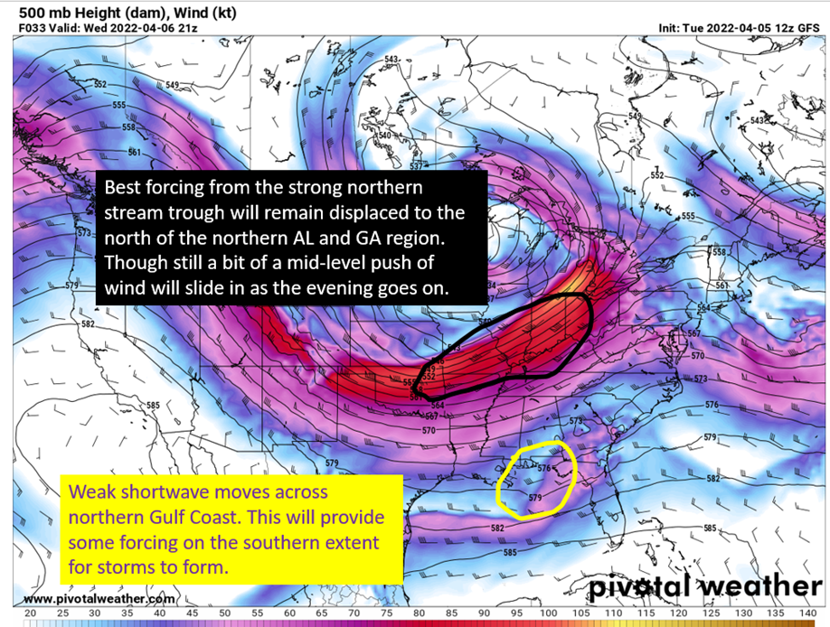
Now to the 500 mb level, where a subtle shortwave will be tracking across the northern Gulf of Mexico that will provide a boost on the southern end of things as well.
The 12z GFS from 4/5/22, showing 500 mb winds and geopotential heights. Image from pivotalweather with annotations by Jacob Caddell.
Once again, the southern expanse (Panhandle and southern AL/GA) have the better dynamic support with the base of a weak shortwave passing through the area. This provides some extra forcing for storms and a localized increase in winds at the 500 mb level. Farther to the north, there is a punch of these stronger winds coming in around a strong northern stream trough but the best dynamic forcing will be displaced to the north of Birmingham and Atlanta interests.
This is the 12z GFS on 4/5/22 showing low-level (850 mb) winds. Image from pivotalweather with annotations by Jacob Caddell.
Once again, it’s the southern end that looks the most interesting from a dynamics standpoint. There’s a localized max of low level winds, some getting over 50 kt in southern Georgia and dipping into the Panhandle. Flow also generally remains out of the south in this region, pushing warmer air into the area. Looking toward Birmingham and Atlanta, the low-level winds are meager and limit the low-level shear available for surface based storms.
At this point though, I’d expect some upgrade potential from the SPC on the southern end of things because the instability will be there and the best dynamics are around there as well. Assuming storms do fire in the southern extent early, this would also serve to limit how much warm moist air can return into the northern parts of AL/GA with southern storms eating the instability to fuel their convection.
Still, with general southerly to southwesterly flow near the surface thanks to a strong low pressure over the Great Lakes, potential is there to get some higher heat content air into the northern parts of the region even with the southern storms.
The 12z GFS on 4/5/22, looking at surface theta-e (think of this as a way to account for warmth and moisture in the airmass) and winds. Image from pivotalweather with annotations by Jacob Caddell.
A cold front will be diving SE across the northern Gulf Coast and the greater SE United States in general. This will provide lifting from the surface and potential for strong storms and especially hail with the cold air and instability aloft. The only problem is it remains quite dry aloft and that will limit how powerful the convection could be due to evaporation cooling but this also provides some downdraft strength within storms so will have to watch for wind as well with storms near the cold front.
Anything that forms ahead of the cold front will have a good amount of instability to work with and while not having an amazing shear profile it would be possible for pre-frontal storms to have large hail, wind, and even a tornado with the abundant instability that will be in the lowest 3km. Convective allowing models are bearish on this scenario but it is worth being aware of the potential if one or two rouge cells were to form in the warm sector ahead of the front.
In the southern extent, there will be good enough surface moisture to support strong to severe storms as well but those will likely be in more of a cluster with whatever outflow boundary the storms today leave behind becoming a focus for storms as the day gets going tomorrow and the shortwave approaches. That should, hopefully, limit the tornado threat somewhat in the that region.
The top down journey tells me a couple of things:
-
The south end needs watching as it looks like it will have the best dynamics and good instability.
-
The northern end has a lot of questions on if severe storms will even happen but with good cooling aloft and some dynamic help, I can see why there is an Enhanced Risk (3/5) from the SPC. It is just not certain anything will be able to form to take advantage of what is there.
The last thing to look at is an HRRR derived sounding for Birmingham ahead of the cold front. The story it tells highlights the failure modes for severe weather, why the tornado risk looks low, and also why there is still some severe potential. Let’s dig in!
The 12z HRRR, a derived sounding for Birmingham, AL at 5 pm tomorrow evening. Image from pivotalweather with annotations by Jacob Caddell.
Nearly 3000 J/kg of surface instability is more than enough to get strong upward motion from convection. Additionally the lowest 3km provide 120 J/kg of that, which is a significant amount at that level. With dew points near 70 and temperatures in the mid 70s and steep lapse rates (cooling with height) above, that’s a good recipe for an unstable airmass. So the low-levels have the juice but limitations start to show themselves as we rise into the column. It’s just really dry above 850 mb, which does lead to stronger lapse rates aloft but also will lead to evaporation of any rising air which would lead to updrafts not being able to sustain themselves and storms collapsing.
If storms try to get going and collapse, you could easily see some strong winds from this process as shown by the 819 J/kg of downdraft CAPE. That’s extra acceleration due to the buoyancy differences on top of gravity pulling on it.
Storms that do survive the dry air aloft will present potential for large hail with the instability in the -10 to -30 C temperature region. Assuming that instability can be realized.
The shear profile is not all that impressive for tornadoes, despite the strong instability from the surface and in the low-levels. Not much change in direction with height at all, and a critical angle of just 26 showing far more crosswise vorticity vs streamwise. This is just not supportive of tornadoes. Shear in general isn’t all that strong but there is increasing speed with height that would help tilt an updraft and why there is still some severe potential, even if the tornado risk does not look all that likely.
The tl;dr version:
Storms should fire in southern Alabama, Georgia, and the Panhandle by early afternoon as a shortwave brings dynamic support and whatever outflow boundaries left behind from today provide a focus for surface convergence. They will likely form a cluster of storms that will have ok shear and plenty of instability to work with. Would not be surprised to see the enhanced risk (3/5 risk) end up farther south by tomorrow’s update from the SPC. These storms could limit instability to the north of them and would further limit the severe potential toward Birmingham and Atlanta. Speaking of that northern end, shear profiles aren’t terribly impressive and would limit tornado risk even if more high heat content air ends up there than implied by the southern storms firing early. There will be some lifting coming due to an incoming cold front and there is substantial instability aloft due to cold mid-level air that cools quickly as you rise. The problem there is the environment will be dry above the surface and this would likely keep deep convection from happening.
Do remember though, if updrafts collapse, there will be high wind potential as the air rushes back toward the ground.
The super short version is to be aware of the severe potential, even though there are a few reasons why it won’t materialize especially in northern Alabama and Georgia. If you get a warning, take it seriously and keep an eye on the radar.
That’s all for today.


