
Severe 101: What is shear? Why does it matter?
During the lead up to severe events, you’ll hear two things mentioned a lot. Instability, which tells you about how quickly air would want to accelerate upwards due to buoyancy differences. Also shear, which comes from velocity (which means speed and direction) differences with height in terms of wind within the environment.
Shear is what organizes severe storms and what tilts updrafts to allow for warm inflow to be unimpeded by the cold outflow as the tilting of the updraft moves the stable downdraft away from the updraft. Shear, especially in the lower levels, is also what causes storms to spin.
This post is going to look at how it is calculated, what values generally mean trouble and it broken down into different levels to see what shear in those layers can mean for producing severe weather impacts.
Calculation:
The calculation is actually quite simple. It is just the velocity vector (speed and direction) of the upper layer of wind in question subtracted from the velocity vector of the lower layer of wind in question. Visually, it looks something like this:

Credit: David Babb
In the above image the bottom later is in green showing wind out of the SW at 10 kts, the top layer in blue showing wind out of the NW at 40 kts, and the resulting shear vector in black showing generally NW to NNW shear with a magnitude of 35 kts.
That’s it. Sweet and simple without complicated formulas to solve or interpret.
There are a couple things I want to note.
-
There is shear even if all the wind is out of the same direction, as long as there is a difference in wind speed with height. (Speed shear)
-
There is shear even if all the wind is at the same speed, as long as those winds are coming from a different direction. (Directional shear)
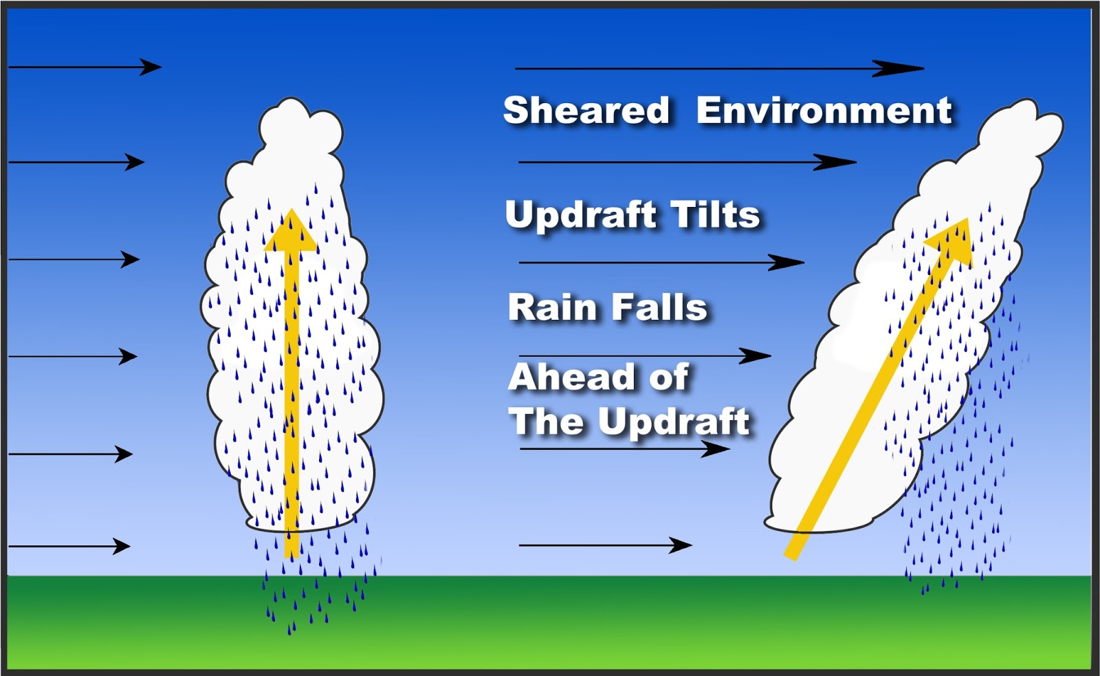
Strong Shear Tilts Updrafts

Image source: NWS Central Illinois Page on Shear
The tilt does one important thing that allows severe storms to remain severe and be longer lasing. It lets the stable rain cooled air fall downwind of the base of the updraft; therefore, the ingestion of warm unstable air isn’t as easily cut off due to the stable air getting pulled in like in the left side of the above image.
Different Layers of Shear:
If you’ve ever looked at the SPC Mesoanalysis page, you’ve seen all sorts of different wind shear parameters. There’s storm relative shear between 4-6 km, bulk shear, 0-1 km shear, 0-6 km shear, effective shear, and it goes on and on. They must be useful right, since why else put them on the page?
Yes, yes they are useful for specific things. Let’s start the rundown.
0-1 km Shear:
This is the difference in speed and direction between the winds in the first km above the ground and the ground level, as the name would imply. This is one of those things I look at for tornado potential, since it is needed to get the updraft spinning close to the ground.
Values that make me pay attention? 15 kts or above is a good rule of thumb, though tornadoes are possible with even less than that.
0-6 km Shear:
Yes, the difference in velocity vectors of the wind between 6 km above the ground and the ground level. This is for supercells generally, as larger values cause the tilting of updrafts mentioned above.
Values that I pay attention to? 40 kts or above, though again, you can get a supercell with less.
Effective Shear:
You might have asked yourself, “but Jake, what happens if the bottom of the cloud is above 1 km? That bottom layer of shear goes into the 0-6 km number, but the cloud won’t feel that part.”
I’d say “good observation reader, that’s why we have effective shear”.
This one is a little trickier to explain. It is based on the most unstable parcel in terms of CAPE. It takes the equilibrium level (the point where the parcel becomes colder than the environment aloft) for that parcel and takes 50% of that height as the top layer. This is to account for elevated convection, where the useful top layer might be above 6 km. The bottom layer begins where the cloud base does, basically. So if the cloud base is 2km above the ground, that’s where it starts.
Values of interest? At least 25 kts.

SPC Mesoanalysis showing effective bulk shear on 4/6/22 at 15z. Two regions stand out. Florida Panhandle and south Georgia and then north Mississippi, Alabama, and central Tennessee.
Non-Shear, but Useful Storm Relative Wind Layers:
4-6 km Storm Relative (SR) Winds:
SR winds refer to winds relative to the storm motion. The useful bit of this layer is it can give hints to differentiate non-tornadic supercell potential and tornado potential.
Typically tornadic supercells will have 15+ kts of SR winds in this layer. Non-tornadic will usually have less.
9-11 km Storm Relative (SR) Winds:
This is at the top of the storm, and it is used to help determine supercell type.
There are three types of supercells: high precipitation (HP – we make a lot of those in the south), classic supercell (the textbook hook echo cell you think of), low precipitation (LP – high plains love making these).
The SR winds at this upper level are used to help figure out what to expect.
HP: Less than 40 kts will tend to be high precipitation, as the precipitation core will not be as displaced from the updraft.
Classic: 40-60 kts will tend to give you a classic supercell
LP: You guessed it, greater than 60 kts will tend to give a low precipitation supercell.
Summing It Up:
This is just meant to be a rough guide and a reference to look at when I talk about shear values. I want you to understand what it is, and have a page to look at to know what values are typically of concern with different layers. This is not meant to be exhaustive, and you see many other values given in a sounding. I will dig into some of those other values when I get to the hodograph explainer.
Remember, shear is what organizes storms and allows for supercells to have longer lives than your typical up and down thunderstorms.
That’s it for this 101, next up I think I will get into the hodograph. I get a lot of questions about those, and they are incredibly useful visual aids to get the shear profile in your head quickly and give all sorts of hints to storm mode, supercell type, and tornado potential just at a glance. Plus, I’ll highlight some of the impressive work Cameron Nixon has been a part of concerning storm relative hodographs.
Related Posts

Hurricane Season 2023 Preview: El Nino Returns

Gulf Low Will Bring Rain and Coastal Flooding

One For The Mardi Gras Skiers

Bust Out The Shorts For Mardi Gras

Hope You’ve Enjoyed Fall So Far. Looking Ahead At The Big Picture Into November.

The Media Coverage Of Ian Has Been Frustrating

Hurricane Ian To Make Second Landfall In Carolinas

Hurricane Ian Strengthens and Grows Larger With Landfall Tomorrow

NHC Forecasting Near Nightmare Scenario For Tampa

One thought on “Severe 101: What is shear? Why does it matter?”
Comments are closed.