
Colorado State Hurricane Forecast
I’ll be back to the severe weather tomorrow, today I want to remind you hurricane season is just around the corner!
Yes, “woooooo!” I know. Wait, why are y’all throwing rotten vegetables my way?
The main takeaway is they are predicting a more active than normal Atlantic hurricane season. This is not surprising with La Nina conditions on going, and while the CSU forecast expects to finally end La Nina at some point this summer it would just shift to a neutral regime.

Image source: WLTX.
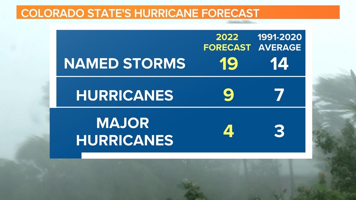
I don’t really concern myself with the deviations from the normal number of named storms. We have better technology now to spot those marginal cases that would not have been named in the past (1990s period specifically), but the hurricane and major hurricane numbers are good benchmarks for a busy/not busy season. As you can see, the forecast is just a little bit above average for both. Do also remember that it is April, and they are using a few measures (that I will summarize below) from the winter months to make this prediction. Which means, it is not perfect by any stretch of the imagination but there is some skill and usefulness to their methods comparing what this forecasting method would predict vs what actually happened.
Those three factors:

Source: Colorado State 2022 Extended Range Hurricane Forecast. Here’s the link to read the document yourself.
-
January to March Sea Surface Temperatures (SST) over Eastern Atlantic
This bit of the forecast has the best correlation to Accumulated Cyclone Energy (ACE) over the course of a hurricane season. This year, the region is 1.5 standard deviations above the mean value for the period in this region. Which points to a more active season. This isn’t unexpected with the La Nina conditions, since that leads to a warmer Atlantic. According to the CSU forecast document, warmer than normal SST here in Jan-Mar typically yield weaker trade winds over the Atlantic in the heart of hurricane season. This tends to lead to warmer SSTs, because there is less mixing with the cooler waters below the surface. The warmer waters lead to lower surface pressures over the Tropical Atlantic and there is typically less wind shear when this occurs. (All of this is from the CSU forecast, I’m just summarizing)
-
Zonal Wind Anomalies In The 200 mb Winds
This piece has the weakest correlation to ACE, but still has some skill in forecasting. Stronger than normal winds at this level of the atmosphere over the winter and early spring will tend to have lower wind shear over the main hurricane producing regions of the Atlantic during the heart of hurricane season. There is also a correlation with this period having stronger upper level winds over the region with La Nina like conditions over the summer. This value was -0.5 standard deviations from the mean, which is actually a negative for an active hurricane season. So one piece of good news, maybe. (All of this is from the CSU forecast, I’m again summarizing)
I worry we could have the same scenarios of the last few years where waves get sheared until much closer to landmasses, which means they won’t be able to turn away from land when they form. That does not relate to how busy a hurricane season is, but could lead to more danger for the US coastline.
-
February to March SSTs near Australia
This is an interesting connection, but it does make sense and has the 2nd best correlation to ACE. Warmer than normal SSTs in this region translate to having lower pressure in the area, and higher pressure in the eastern Pacific. This leads to an increase in trade winds across the Pacific, which means more mixing of the water and significantly decreased odds of El Nino conditions happening. This leads to reduce trade winds in the Atlantic and reduced shear in the basin, which is helpful to tropical formation. This year, the region is 1.5 standard deviations above the mean which signals a more active season. (All of this from the CSU forecast)
Summary:
#1 and #3 have values that correlate to a more active Atlantic hurricane season, where #2 would suggest a less active season. Since #1 and #3 have the better correlation to ACE over a season, the forecast is for a busier than normal season.
Remember though, it only takes one storm for it to be a “busy” season in your location. There were not many hurricane landfalls in the United States last year, but I’m sure SE Louisiana will remember the 2021 with much malice in their hearts.
Want some good news? I won’t talk about hurricanes again until May.
Tomorrow, I’ll be back to dig into the severe weather outbreak potential for next week. Until then, enjoy the perfect weather in the Southeast today and don’t start any fires!
Related Posts

Hurricane Season 2023 Preview: El Nino Returns

Gulf Low Will Bring Rain and Coastal Flooding

One For The Mardi Gras Skiers

Bust Out The Shorts For Mardi Gras

Hope You’ve Enjoyed Fall So Far. Looking Ahead At The Big Picture Into November.

The Media Coverage Of Ian Has Been Frustrating

Hurricane Ian To Make Second Landfall In Carolinas

Hurricane Ian Strengthens and Grows Larger With Landfall Tomorrow

NHC Forecasting Near Nightmare Scenario For Tampa
