
Models (Finally) Converge On Solution. Doesn’t make the forecast any easier.
After a long week of significant differences between the European and GFS, we finally have some agreement this afternoon on timing for the upcoming severe weather. It looks like Wednesday will see the longwave trough eject east and bring the threat of severe weather into the Gumbo Weather region (LA, MS, AL, AR). There are still differences between models at this point, but there’s enough agreement to talk about the big picture each day at this point.
In addition to the obvious Wednesday threat, I’ve also got to talk about Tuesday. The greatest threat should be in the plains on Tuesday, but as models continue to show a southern shortwave eject on Tuesday I will need to talk about the subtle potential for severe weather Tuesday into SE Texas and SW Louisiana.
I’m going to start with the potential in SETX/SWLA on Tuesday, but know the most obvious threat would be in Kansas/Oklahoma/Missouri. Then I will move into Wednesday. This won’t be a full detailed top down analysis at this point, just adding more detail to the big picture as there is enough model disagreement to be weary of too much detail at this point.

The 12z GFS from 4/9/22, showing the 500 mb winds and geopotential heights. Image from pivotalweather with annotations by Jacob Caddell.
This little disturbance remains a concern, though at this point it remains a conditional threat. Specifically, on the conditions the low-level winds are stronger than the models think they will be. The instability remains a question too, as this would be an early afternoon threat for the circled region per the GFS. Additionally, the low-level shear isn’t overly impressive but enough to support tornadoes. The overall shear profile is supportive of supercells, but we could also see a more linear mode that would limit the tornado threat somewhat. All of that said, the critical angles shown on GFS soundings for SWLA are near 90, which would mean nearly perfectly streamwise vorticity for a tornado to work with.
This is not a slam dunk set up, but I tend to think the odds of severe for this region higher than the SPC which is not highlighting the area at this time. Those guys and gals are excellent severe weather meteorologists, so they may be seeing something I’m not. I just want to highlight I believe there is some sneaky severe potential down this way on Tuesday. If the threat remains on all of the major models tomorrow, I will do a top down analysis to evaluate the risk in detail.
Overall, there is an obvious area of risk from eastern Oklahoma, Kansas, and western Missouri on Tuesday. Some of the model derived soundings from these regions are extremely impressive (which is never a thing you want me to say). The risk will extend eastward into Arkansas, Missouri, and a portion of northern Louisiana too. Though I do wonder if the Oklahoma portion might have the teeth taken out of it from being downstream of the SETX/SWLA convection. If I were a chaser, I’d go farther north toward NE KS and SW IA.
Once again, I intend to dig into the Tuesday details deeper in a later post. If the Thursday post was setting the table, this post is meant to give you the menu.

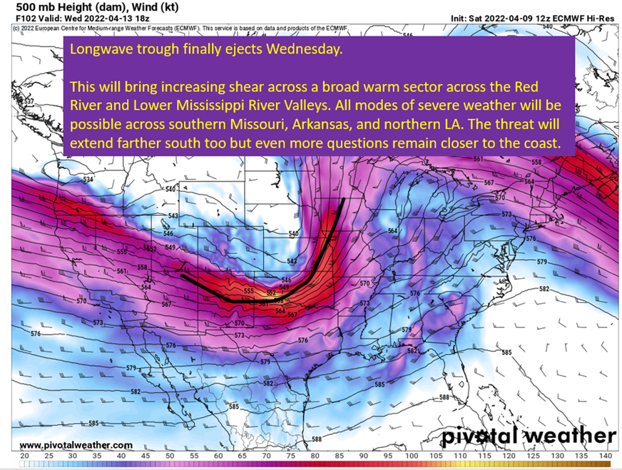
The 12z European model, showing 500 mb winds and heights on Wednesday at 1pm central. Image from pivotalweather with annotations by Jacob Caddell.
The good news is the GFS and Euro basically agree on the timing, with some differences in placement. The bad part is the solution leaves a lot of questions for Arkansas, Louisiana, and Missouri.
The surface low on both models ends up into Minnesota at this point, well removed from the area of greatest risk. I’d have more confidence if it was running into Iowa, but there will still be plenty of severe potential with this robust of a trough moving across the Plains. Another question is how well will instability recover across northern LA, AR, and MO as it is likely convection will be ongoing in the morning hours. This could mean the atmosphere can’t recover, despite the low-level flow pumping higher energy air northward through the day, and limit the extent of severe weather into the afternoon.
The strongest low-level winds will be focused over Arkansas though, and support enough shear at the lowest levels for all modes of severe weather. The tornado threat isn’t so clear, given the questions around surface based instability due to earlier convection, but there will be plenty of high wind and hail potential with any storm that can get going even if not surface based.
This is tricky y’all. The trough is taking a negative tilt, which is conducive to severe weather. The low-level winds would appear to be there as well. At the upper levels, some divergence will be there over the MO/AR/LA area and will be roughly near a “right entrance” of a jet stream max. That combined with the likelyhood of a broad area of instability to settle in over the area, all suggests significant severe weather potential.
That all being said, ensembles are starting to cluster the surface low up into Minnesota which is just a little too far away for me to be certain it materializes. In addition, early in the day convection could limit overall instability. Strong potential for severe, but just as strong of a bust potential exists with this.

The 12z GFS ensemble members, showing surface pressure anomolies and positions of high/low pressure from each member. Image from pivotalweather.
Tl;dr version:
This is just a difficult forecast, especially on Wednesday.
The ingredients will be there across LA/AR/MO for significant severe weather, and the SPC highlighting the region with a 30% risk five days out does make sense with the pieces in play. Don’t sleep on the potential. Unfortunately, the certainty of severe weather happening in that region just isn’t quite there with the expected position of the surface low and questions over instability available. Still need to watch this evolve before I can say much more with confidence. Sometimes you just have to say “IDK yet”.
Tuesday looks potent across the eastern Plains as a dry line will spark storms that will enter a robust environment to support severe weather into North Texas, Oklahoma, Kansas, and far southern Iowa. Excepting a lot of storm chasers to be roaming the eastern Plains. In addition, there is a subtle threat for severe weather into SETX and SWLA. Not everything is lined up quite right in the region, but I think there’s enough to start mentioning some potential will be there.
Wish there was more clarity tonight. Hopefully I’ll have some to report tomorrow.
Related Posts

Hurricane Season 2023 Preview: El Nino Returns

Gulf Low Will Bring Rain and Coastal Flooding

One For The Mardi Gras Skiers

Bust Out The Shorts For Mardi Gras

Hope You’ve Enjoyed Fall So Far. Looking Ahead At The Big Picture Into November.

The Media Coverage Of Ian Has Been Frustrating

Hurricane Ian To Make Second Landfall In Carolinas

Hurricane Ian Strengthens and Grows Larger With Landfall Tomorrow

NHC Forecasting Near Nightmare Scenario For Tampa
