April 27th: Memories Of The Super Outbreak
Most days I spend doing forecasting of my own and trying to explain why things happened or are going to happen. Today though, I want to go back through the memories of forecasters on 4/27/11. From James Spann’s marathon on the air to the story from one NWS Huntsville meteorologist working the operations side of that day. The challenges of that day were immense, especially in terms of getting the warnings to those who needed them.
Two rounds of storms earlier in the day meant numerous power outages within the region in the most danger and social media wasn’t to the point where it was a resource to get information to the public. Today, on the 11 year anniversary, let’s go back through the meteorologists memories of the day.
And remember the 348 people who lost their lives from the storms on that fateful day.

Early Storms Knock Out Power And Communications

That early morning line of severe storms with embedded tornadoes set the stage for a difficult day in terms of getting warnings to the people who needed them. According to this Washington Post story, this line of storms knocked out NWS radio transmitters and almost one million people lose power in Alabama. James Spann remembers the chaos following that line of storms, quoting from the same piece:
“It was like somebody punched us in the gut,” said Spann, whose station was left crippled. “You had half a million people with no power, infrastructure damaged, cameras out, Internet out. … We went back to programming at 9 a.m., and [engineers] streamed in there and said, ‘This isn’t working,’…”
Washington Post: “Remembering the April 2011 ‘Super Outbreak,’ an unprecedented swarm of tornadoes”
Farther to the north, NWS Huntsville meteorologist Chris Darden remembers the worry over the loss of power from this potent line of storms:
“Parts of northeast Alabama and southern Tennessee were badly hit by the morning storms, with winds likely exceeding 100 mph in places by what could best be described as a small inland hurricane. Many areas would lose power for the remainder of the day which would be an issue in terms of alerting and awareness for the afternoon storms. Even at the time that was a huge concern for us, and some counties were already swamped and requesting mutual aid assistance.”
alabamawx: The April 27th, 2011 Super Outbreak in My Own Words by Chris Darden
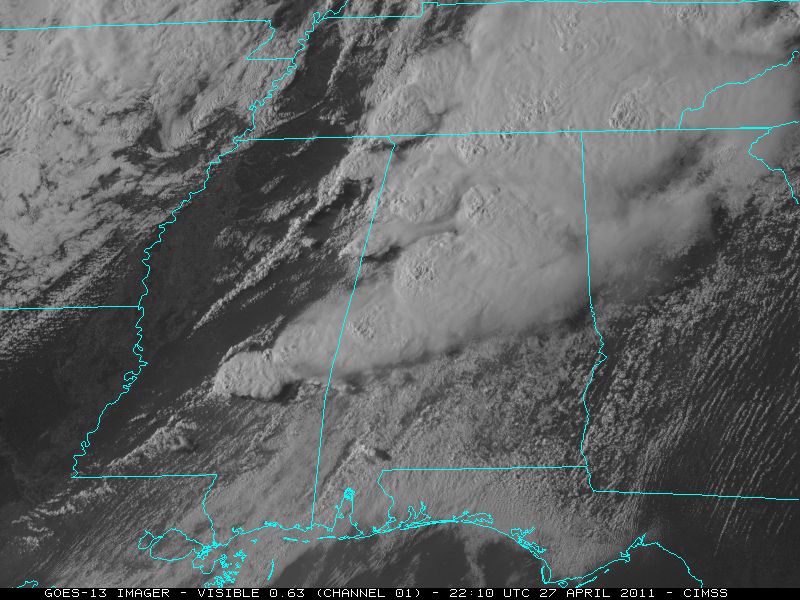
This Early Line Was Much Stronger Than Expected
To make matters worse, few were prepared for the strength of this early morning round of storms. Going back and reading through forecast discussions from NWS Birmingham, they were not especially concerned about the severe potential with the morning round. NWS Huntsville did mention some severe potential in their discussion on the afternoon of 4/26.
“SO…WILL GO WITH HIGH POPS FOR TONIGHT IN ANTICIPATION THAT THE LINE OF STORMS WILL MOVE ACROSS MOST IF NOT ALL OF THE AREA. PW VALUES IN THE NARROW CONFINED CHANNEL OF DEEP MOISTURE WILL LIKELY BE ARND 1.6-1.7 INCHES CAUSING VERY HEAVY RAINFALL AND EXACERBATING THE FLASH FLOOD THREAT…PARTICULARLY IN NW ALABAMA. HOWEVER…ANOTHER REAL THREAT WILL BE DUE TO WIDESPREAD DAMAGING WINDS WITH A POTENTIAL BROAD BOWING SEGMENT. SHEAR MAY BE EQUALLY SUFFICIENT TO PRODUCE EMBEDDED SUPERCELLULAR STRUCTURES ALONG THE LINE…GIVING RISE TO A TORNADO THREAT EVEN LATE TONIGHT AND EARLY TOMORROW. “
NWS Huntsville AFD From 3:55 PM Local on 4/26/11. Read the whole thing here
They got this bit right but still not the level of wording I’d expect with what resulted the next morning. The atmosphere never makes it easy.
Second Morning Round For North Alabama
Just as the first round moved out, another surprise round fired for NE Mississippi/NW Alabama and central Tennessee. This line of storms once again brought strong wind and embedded tornadoes, knocking out power to even more locations that would be in the thick of it by the afternoon. It also brought a brief moment of hope for the NWS Huntsville office. That maybe, just maybe, this round would keep the instability at bay.
“As soon as these morning storms moved off into Georgia and east Tennessee, another small but fast moving line began approaching northwest Alabama. These storms were, for lack of a better word, completely unexpected and threw a wrench into morning recovery efforts. This line produced periodic tornadoes and extensive damage particularly in parts of Limestone and Madison counties. In fact, many areas north of Highway 72 from Athens to Huntsville that were mostly spared by round #1 would lose power with these storms and never regain it again for days.”
NWS HUN meteorologist Chris Darden. https://www.alabamawx.com/?p=228265

The Parade Of Tornadoes

“We had the supercell that formed north of Jasper, and I saw the kidney bean shape,” said Spann. “I thought, ‘It’s go time.’ I looked at him [Jason Simpson, the morning meteorologist] and we shook our heads. I don’t think either one of us thought we’d go back to [regularly scheduled] programming for quite some time.”
James Spann. WAPO Article
“I recall at one point in the very early afternoon thinking (perhaps hoping) that this unexpected midday line of storms might put a damper on the potential for afternoon and evening supercells. A quick conference call with the Storm Prediction Center (SPC) put those hopes to rest. I probably can’t say the exact words here, but let’s just say the SPC forecaster was very descriptive in his terms for how the afternoon was going to go.
Although after 10 years my memory is a bit hazy, I recall us having a very brief/impromptu internal meeting in the Huntsville operations area and deciding that we would only issue Tornado (TOR) Warnings through the remainder of the event. Any storm that didn’t warrant a TOR would not get any alert given the limited available infrastructure and trying to streamline communications going to the public.”
Chris Darden. https://www.alabamawx.com/?p=228265
SPC Mesoscale Discussion Not Parsing Words

” PARTICULARLY DANGEROUS SITUATION /PDS/ TORNADO WATCHES 232/235 CONTINUE UNTIL 00Z/03Z RESPECTIVELY.
THIS INCLUDES THE POTENTIAL FOR LONG-TRACK STRONG/PERHAPS VIOLENT TORNADOES INTO THIS EVENING AS A SEVERE WEATHER OUTBREAK ONLY INCREASES IN MAGNITUDE/RISK.
AN EXTREMELY DANGEROUS/LIFE-THREATENING SITUATION CONTINUES TO UNFOLD THIS AFTERNOON ACROSS A LARGE PART OF MS/AL…WITH ADJACENT PORTIONS OF TN/NORTHWEST GA ALSO EXPECTED TO BECOME A CONCERN LATE THIS AFTERNOON/EVENING.
CURRENT OBSERVATIONAL TRENDS…REASONABLY SUPPORTED BY EXPERIMENTAL HRRR GUIDANCE…IMPLY THAT SCATTERED SUPERCELLS WILL CONTINUE TO FORM IN BROKEN NNE-SSW ORIENTED CORRIDORS OF SUBTLE CONFLUENCE AHEAD /EAST/ OF MORE STORMS/SUPERCELLS THAT ARE DEVELOPING ALONG A PRE-COLD FRONTAL TROUGH/DRYLINE GENERALLY NEARING I-55 IN MS. “
SPC Mesoscale Discussion 629. Archive of SPC products found here
This strong wording was warranted, as by the end of the day Alabama alone experienced 11 violent tornadoes. Below I’m going to look at a few of the most memorable tornadoes of the day. This won’t even come close to covering all of the violent tornadoes but this post would be three pages long if I tried to cover them all.
The Tuscaloosa Tornado

This tornado was perhaps the most well known of the entire outbreak, because it went through a well known college city. It ended up killing 43 people, not including 13 more who had deaths indirectly related to the tornado.
At 4:43 p.m., an EF4 tornado with winds up to 190 mph touched down in Greene County and began its deadly journey toward Tuscaloosa. Across central Alabama, television viewers watched in horror as the tornado tracked straight through the heart of the Druid City, barely missing DCH Regional Medical Center. The tornado ultimately traveled 80 miles, killing 43 people including six University of Alabama students. Another nine died later from injuries related to the storm, according to city of Tuscaloosa figures. Whole sections of several Tuscaloosa neighborhoods were flattened.
https://alabamanewscenter.com/2021/04/19/ten-years-later-april-27-tornado-outbreak-still-scars-alabama-landscape-and-hearts/
Watch 14+ minutes of James Spann covering this tornado below:
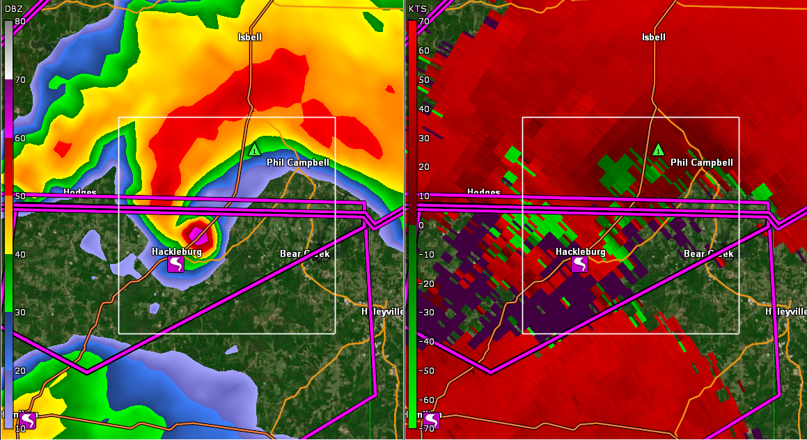
Hackleburg – Phil Campbell EF5
With estimated winds of 210 mph, this was the deadliest tornado in the history of Alabama. It killed 72 people and devastated the communities of Hackleburg, AL and Phil Campbell, AL.
The next big storm to impact north Alabama was what would later be called the “Hackleburg tornado”. On radar, this storm looked extremely ominous with a notable debris ball (indicative of tornadic debris) as it moved through the town of Phil Campbell. Keep in mind, this event occurred just before the NEXRADR Dual Pol era, but we did have access to Dual Pol data from the local ARMOR radar which proved quite beneficial to assess the depth of the debris layers with many of the storms.
Perhaps the most concerning part of that time period is we were hearing nothing out of Franklin County. A good rule of thumb is if you aren’t hearing anything out of a city or county when an expected large tornado is moving through, you know it’s really REALLY bad. Anxiety was high in the office by this point as we had high end tornadoes on both ends of our area, and the storm moving out of Franklin county was making a beeline toward Huntsville if it held together. The reality strikes you that people are dying and you feel somewhat helpless.
Chris Darden of NWS HUN. https://www.alabamawx.com/?p=228265

Kelly Dobbs works at Ray Pharmacy in Hackleburg, just as she did five years ago. She survived the tornado even as the pharmacy collapsed around her and her daughter, Kaelyn. That day, Kaelyn turned 1. “We dug out,” Dobbs said. “I don’t know how.”
Dobbs and her daughter were trying to get to a safer building next door but didn’t make it. “We fell down and I covered (Kaelyn). I wrapped my arms around her. We covered up. People thought we were dead. The whole building collapsed.”
al.com article at the five year anniversary

We walk up to the remnants of one home and there’s a lady and her son sifting through debris. She tells us she’s from Arkansas and her dad died here. We ask her if there’s anything we can help with, and she thanks us but responds not really she’s just looking for anything of value. We notice that she has collected some family photos. She then asks us if we noticed the street driving in. Mike and I look puzzled so she points toward the road. We notice that it looks in ill repair with parts of the road missing. She said it was just resurfaced not long ago and that was the first thing she noticed when driving in that the tornado had ripped up the roadway.
Chris Darden. https://www.alabamawx.com/?p=228265
Philadelphia, Mississippi EF5

This tornado, thanks to the very rural area it went over, only caused three deaths. I hate to say “only” when people lost their lives, but it is just in comparison to the two tornadoes above. The storm report from NWS Jackson gives details into the immense power of this tornado.
The three fatalities occurred in northwest Kemper County when a strapped down doublewide mobile home was thrown a distance of approximately 300 yards into a treeline, and then obliterated with the debris and framing scattered many hundreds of yards down the path. There was no indication of ground impacts between the original site of the mobile home and where it ended up to indicate that the mobile home bounced extensively as it travelled.
Two traditional frame brick homes in southeast Winston county were completely leveled with only a few small parts of interior walls standing. New vehicles were thrown or rolled hundreds of yards before being wrapped into trees and left almost beyond recognition. In parts of northeast Neshoba and northwest Kemper counties, there was very high end tree damage with extensive denuding and debarking of trees, along with areas where the ground was scoured out to a depth of two feet in places, and asphalt was scoured off pavement.
NWS Jackson Storm Report
Threw a mobile home 300 yards. Didn’t bounce it across the ground for 300 yards, threw it into some trees and shredded it with debris. It’s hard to imagine that kind of power. Then again, it was so powerful it ripped the top layer of soil off the ground! Got some storm chaser video below who captured a portion of this tornado.
Wrapping It Up
This was, hopefully, a once in a generation event for one of the most tornado prone areas of the country. The extreme danger was only made worse by early in the day storms that knocked power out, effected NWS radio transmission, and stretched first responders thin before the main event began. One big difference from the current day was the lack of social media as a medium to get warnings out. Sure, it might lead to extra hype for events, but it also likely saves people’s lives that are in harms way.
Below I’m going to link a couple of sites to check out for more and link to the entire 8+ hours of James Spann’s coverage on this tragic day.
Alabamawx post of NWS Met Chris Darden’s Memories of 4/27
Treasure Trove of Data From NWS Birmingham and Huntsville