Hurricane Season: GumboWx Forecast Philosophies
Any of you who know my work before making this site know me mostly for tropical weather. I intend to make it a cornerstone of this site, with detailed breakdowns of every storm from wave to extratropical transition. I will be doing long range discussions every couple of weeks as well. Finally, I’ll be producing frequent updates about threats to the United States.
Since my time early this week is taken up with other obligations, I am lacking in time for deep dives on the severe threats. So this seems like a good time to discuss how I approach hurricane forecasting.

I Won’t Make Landfall Location Predictions
I don’t believe in a centerline prediction, at least not in a free access site the general public has access too. For one thing, the NHC is really really good at track at this point. I’m not going to try to beat them on that, since it’s the best resource for track forecasts anyway. I will produce my own cones though, based on the NHC cone and trying to correct for levels of certainty in the forecast.
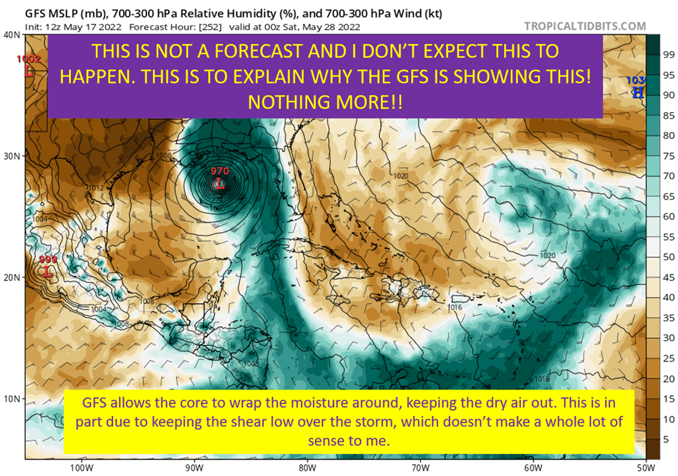
The NHC Cone Is Based On Errors Over The Past Five Years

First off, I’m uncertain of the source on the above image. If it’s yours, please let me know to credit you and link to you.
Second of all, the NHC cone is based on 66% of the track error over the past five years at a given point in time. So, at the 36 hour forecast point, the each side of the cone represents 1/3 of the track errors in the last five years. It is not dynamic. In other words, it isn’t going to show you how certain or uncertain the NHC tracks are.
I’m going to try and do that for you. I’m not generally going to have a smaller cone than the NHC, though will note why the track certainty is high when that is the case. When it is not, I’m going to go wider to demonstrate that fact.
Reasonable Range And “Most Likely Range”

The reasonable range is going to be my cone, literally trying to cover every reasonable scenario on track (and intensity for that matter). Then I will have written discussions on the most likely outcome, or at least the range of the most likely outcome.
This gets to the core of how I think about a hurricane forecast. The game isn’t about figuring out where it is going or exactly how strong it will be when it does. It is about elimination of possibilities until you have the answer. I don’t want to get stuck on some call I made, I want to narrow down who needs to be worried and what they need to prepare for.
The goal is to give you context of what could happen, and the reasoning of how each question mark in the process ends up affecting the end game of a storm. I want to supplement what the NHC and your local NWS office produce and be somewhere you can trust to filter through all the noise and different model runs and actually understand what is happening and why a model run shows what it shows. Oh and if that model run even makes sense.
tl;dr version
This isn’t a blog that is going to attempt to do what the NHC does better than they do, it is to supplement what they do. I want to give you the context of what they are looking at, game out the “what ifs”, and give you a place to escape from the noisy social media of model runs and uneducated speculation. I hope you join me as hurricane season progresses, and I hope this site can be a resource to help you understand what is happening with any given storm.
Respect the cone, listen to warnings from your local NWS offices, and come here to understand what is happening a little better.
That and I hope none of you have any warnings to worry about after the last few years.