The Central American Gyre Is About To Get Going

The Rundown
For me, hurricane season doesn’t start on June 1st. It’s when the GFS starts producing phantom hurricanes that will never happen or when the Central American Gyre (CAG) gets spinning. Good news, the GFS has already started and there’s increasing odds of getting the CAG spinning by the end of next week. A, and I’m sorry for this, Convectively Coupled Kelvin Wave (CCKW) will be pushing across the Pacific and into the Atlantic by late next week. This will induce westerly flow in the Pacific as trade winds increase in their easterly flow. That will likely lead to a broad rotation across Central America, called the CAG.
The reason I care is that these often are the genesis for early season tropical systems.
The Big Spin

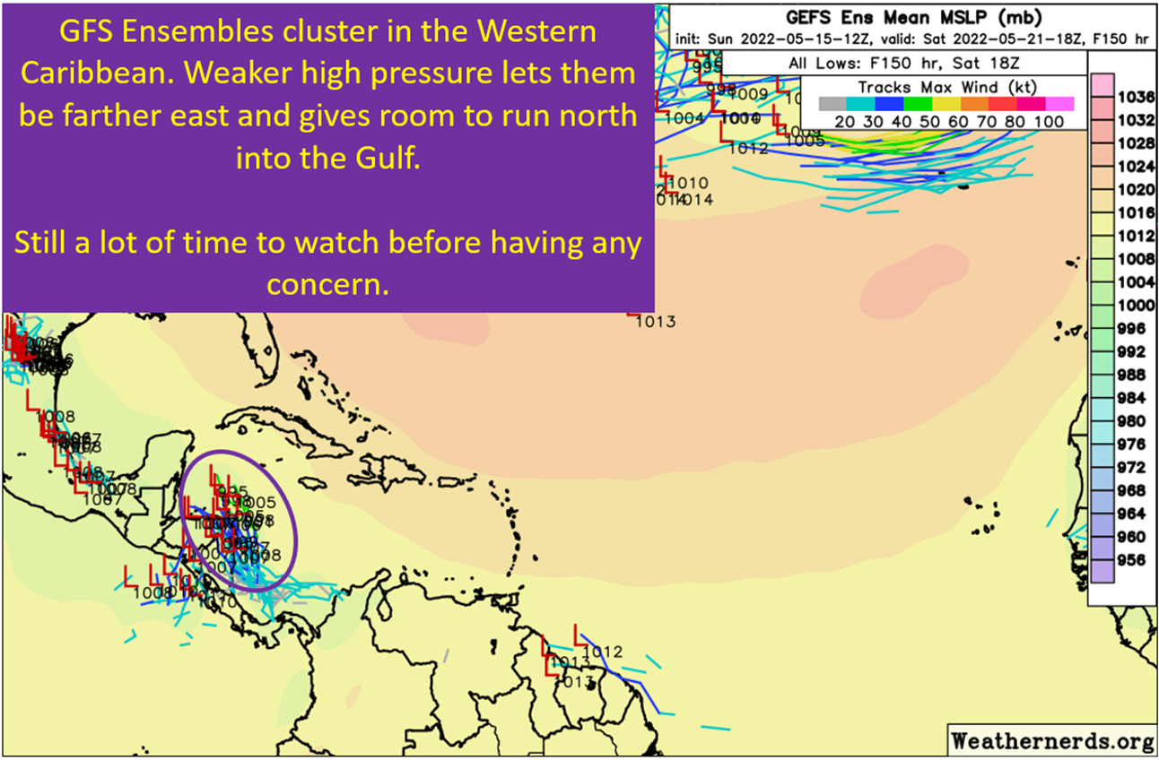
The idea here is you get strong easterlies on the north side and westerlies on the south side and you get a general counterclockwise rotation. These circulations are broad and are known to bring heavy rains across Mexico and Central America when they form. Don’t focus too much on the exact location of the circulation just yet either, because there remain modeling differences on where it eventually gets spinning. This is not unusual to see in May or June. What should happen is there will be a broad area of persistent thunderstorms over Central America and the Caribbean.
Of course, if it storms long enough over the warm water you have the potential for….
Tropical Development Within The Gyre
Get enough convergence at the surface to keep thunderstorms persistently firing over warm water and eventually a tropical cyclone will be able to form. Claudette in 2021 and Christobal in 2020 are good examples of a cyclone forming within a broader CAG. This is something I’m going to be watching for over the next week or so, as the GFS/GEFS depiction would favor the Caribbean vs the Pacific for formation. The European model depicts a different solution though that would more favor the Pacific side.

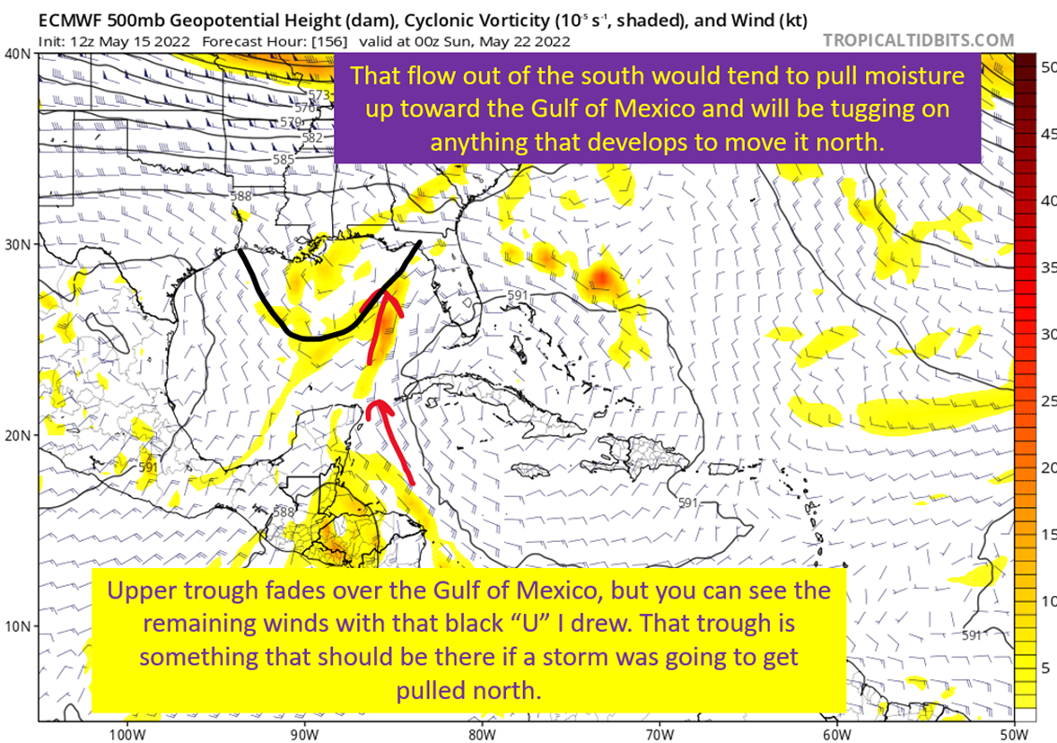
Good News: It’s May And There’s Gonna Be Shear
Looking ahead, if this system were to form and lift north, hostility awaits it. The Gulf of Mexico is projected to have abundant shear overhead that would disrupt any attempts at meaningful strengthening. In addition, tropical cyclones that form off the CAG are prone to be large and not tightly wound. It takes time and benign shear to allow storms like that to tighten up into something that could turn into a hurricane.
I would expect, if it forms, something like a weak TS going somewhere along the Gulf Coast.
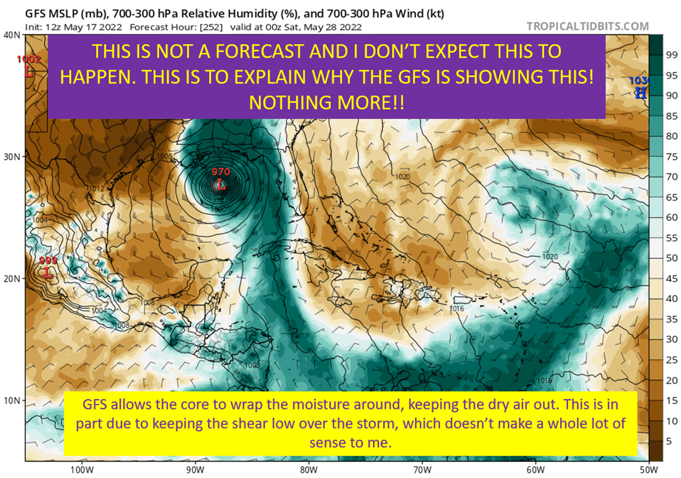
Now, an aside about the GFS solutions thus far.
The GFS Strengthens Far Too Aggressively To Be Believed
The GFS has been strengthening this into a 970 mb type storm by the time it would get into the Gulf of Mexico. This is unrealistic given the conditions at hand. The reason for this is the GFS strengthens it too quickly, which allows it to produce enough outflow to push through the shear ahead of it and get a pocket of favorable conditions. It’s May, with a broad circulation off the Gyre. I very much doubt it goes from a newly formed TS to a hurricane within 24 hours.
So ignore the pressure please while I show you the shear projections.

tl;dr version
We’re getting into hurricane season, and this is typically how it starts for us on the Gulf Coast. Gyre gets going, we spend days wondering if something will form off of it. Then, if it does, we watch a weak storm cross the Gulf. Now, there are always some communities that are low lying enough where even a weak storm can cause flooding issues. I never mean to discount that, but I do want to note I’m not expecting anything all that disruptive even if it does form and come into the Gulf. Shear will be high, a potential storm will be big and slow to develop.
Finally, to illustrate how uncertain these gyres can be, I’m going to show you the Euro ensembles for it. There’s a split between Caribbean and Pacific members and many don’t form anything at all.

So don’t listen to anyone hyping it up with those GFS runs. They’re not acting in your best interest if they show it without context. The reality is there’s a chance a tropical system forms on the Caribbean side, but there’s potential it’ll form on the Pacific side or even not at all. If it does form, it’ll probably be weak.
Related Posts
Expecting Danielle By The Weekend. Otherwise, Shear and Dry Air Dominate.
The “Ring of Fire” Continues and Weekly Tropical Update
Summer Of The “Death” Ridge: Hot but Helpful In Terms Of Tropics
Discussing The Hurricane That Isn’t Happening, Again
In A Huge *NOT* Surprise, The May Hurricane Isn’t Happening