The First of the Atlantic Season. TS Alex Is Forming.
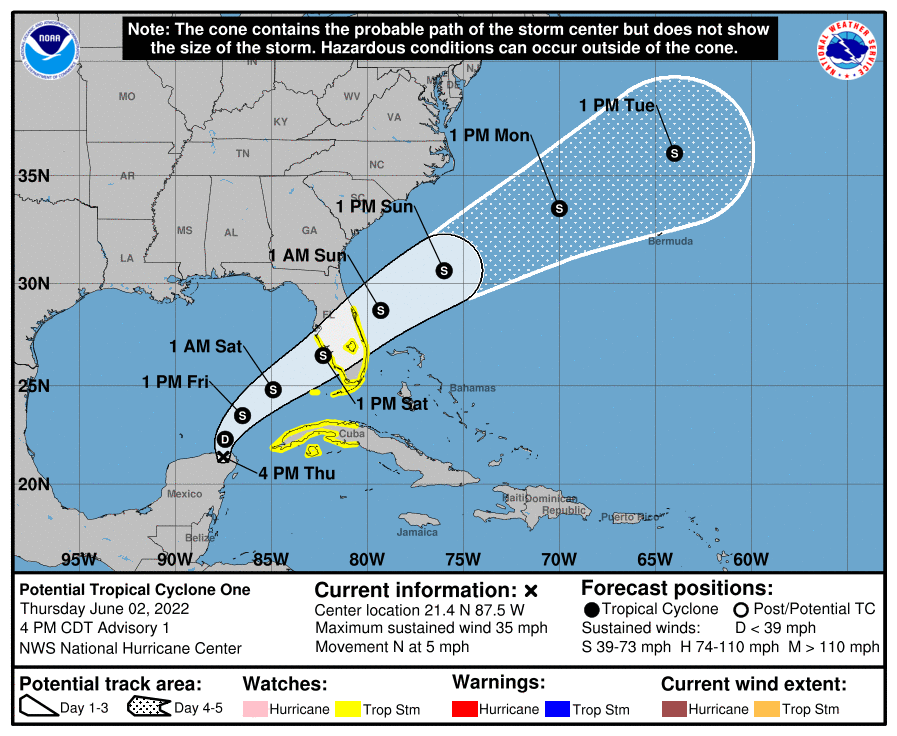
I’ve been a bit busy up here in Colorado, and this one has snuck up on me. The good news is the wind threat isn’t going to be significant. The concern, as usual with early season storms, is going to be flooding. In this case it will be south Florida. Alex is going to be slow to form with unfavorable upper level winds and a broad circulation, potentially with competing vorts. So come get to know future Alex with me.
91-L On A Cancun Vacation Currently

Future Alex is currently a mess. The surface low is well displaced from the convection and broad mid-level rotation out to the east of the system. The shear isn’t usual for this time of year, and looks to remain and keep whatever forms a sloppy rainmaker as it moves across Florida. Models have wanted the center to be farther southeast this morning than where it actually is. Just realize the models aren’t going to get the details right until a good enough center of circulation can form.
Shear To Remain Aggressive

The shear will keep Alex from developing much, keeping the organization lacking and weather all on one side (east). In addition, the shear is going to work dry air into the system and defeat attempts to put convection over the low level center.

The endgame being a weak tropical storm pushing a lot of rain across Florida and dry out behind it.
Flash Flooding Concerns In Florida With Future Alex
Just take a look at the European Model from 12z below, widespread swath of 6″+ of rain by Sunday night/early Monday.

The exact details on the flooding threat aren’t quite clear, but all interests in south Florida should be keeping a very close eye on this. With precipitable water levels forecasted at 2.2-2.4″ on Friday, the heaviest rain bands will produce prolific 2-3″ hourly totals. Anywhere those bands sit over (and areas they drain too) could be in for a significant flooding event. Currently, the WPC has a moderate risk over southern Florida on Friday but I could image that having an upgrade area somewhere in southern Florida.
tl;dr version
Now PTC 1 and future Alex will continue slow and disorganized development until it crosses Florida this weekend. The main threat is going to be excessive rainfall somewhere in southern Florida. A moist tropical airmass with a tropical cyclone to lift it will produce prolific rainfalls. The wind shouldn’t be much of a treat as Alex will struggle under the shear and dry air to organize this large area of moisture and spin into something resembling more than a minimal tropical system. Future Alex will keep moving NE through the weekend and end up in the open Atlantic after that.
That’s all for today.