Sometimes Plugins Don’t Play Nice. Plus Long Range Weather
GumboWx had some downtime recently. I couldn’t get into the site the normal way. It took me getting some free time to fix it.
I knew it was trouble when I got an email saying a plugin had updated and almost immediately got a notification the site was down.
Enough about my boring website disasters, I want to look ahead at the pattern for the next ten days or so.
This Week: Storms North of I20, Hot Everywhere

Where those disturbances, shown above, track over will see enhanced chances of showers and thunderstorms. Generally this would be north of I20. Otherwise it will be hot with temperatures near or above 90. To the south of I20, small ridge builds over Texas and keeps things hot and rain free until the end of the week. I would not be surprised to see a nasty complex of storms diving southeast by the Friday/Saturday and pushing toward the coast.
Even without a convective complex, storms will be back by the weekend for everyone in the southeast as a more potent upper level disturbance dives in from the NW.

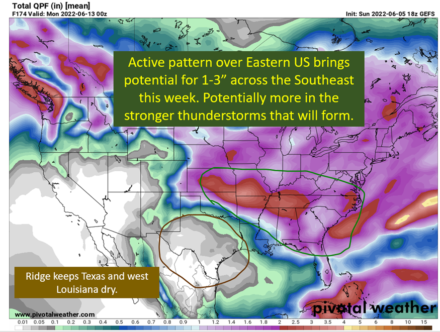
Texas Stays Dry. Southeast In For Typical Afternoon Thunderstorm Pattern

The southeastern storms will prove to be efficient rainmakers, so expect some locations to receive more than shown in the model depiction above. Louisiana could see more than this if some convective complexes end up diving SE ahead of the system at the end of the week. These systems aren’t easy to predict in advance, but conditions will be there to support them. Otherwise, reasonably stormy week for most of the Southeast.
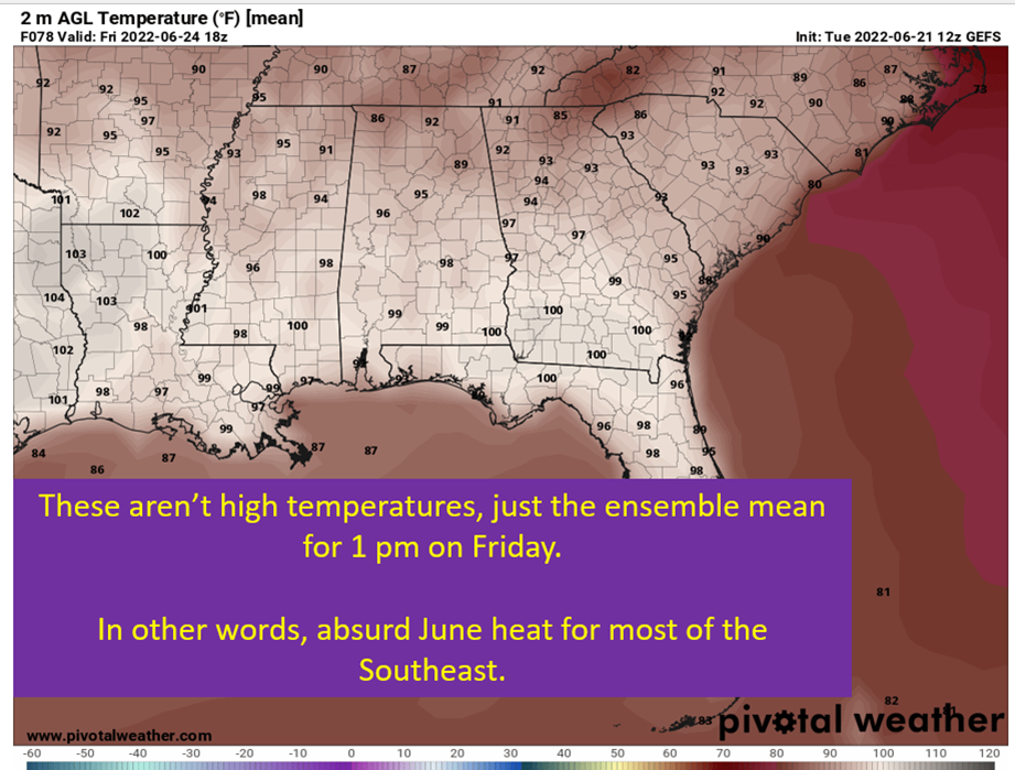
Following Week: Heat Builds Back Into Southeast

The above shows the range of temperatures from the average temperature for this time of year. The number on the left is the deviation from that average temperature on the downside. The number on the right is the deviation from the average temperature on the upside. These points take in all the temperature outputs from each ensemble member. Then it puts them in a normal distribution and does some statistics. The lower number is where 90% of the temperatures produced by the ensembles at this timeframe mark the low end. The high end, the point where 90% of the temperatures is cooler.
In other words, odds are it will be warmer than normal the week after next.
This follows what both the European and GFS ensembles are showing at the 500 mb level at the time. The general idea is to paint a large upper level ridge over the southern part of the country. This would bring reduced rain chances and warmer temperatures from Texas to North Carolina.

tl;dr version
Rain chances all week north of I20 but will remain seasonally warm. To the south of I20, rain remains sparse until the end of the week but at least it will be hot! Boooo! Temperatures in the 90s and sunny will be the story closer to New Orleans and Baton Rouge. Rain and cooler temps for all by the weekend with a strong upper level system moving through.
Into the following week, ridging will build in over the southern central of the country. This will bring reduced rain chances for most and likely to see warmer than normal temperatures.
That’s all for today. Will be looking into what might be ahead for the tropics later this week.