
Southeast Diving Line Of Severe Storms Tomorrow
I mentioned the possibility in my post earlier this week. It now is likely that a convective complex of storms will dive southeast across Alabama, Arkansas, Mississippi and Louisiana tomorrow afternoon and evening. The culprit is a shortwave currently coming over me in the Rockies. This will amplify as it crosses the Plains tonight. The lift will provide the impulse for thunderstorms to form over Arkansas. The cold air rushing out in front will act as a little cold front and lift the muggy summertime air in front of it.
Creating a process that will push a line of storms all the way to the Gulf of Mexico by evening.
Severe warnings are likely due to wind near and at the lead edge of the thunderstorms. In addition, this airmass is going to be very buoyant. It seems likely there will be bowing segments and rear inflow jets form at times in the complex.
Wind is the main threat. There will be a ton of lightning. There will also be a badass shelf cloud with it.
Miserable Summer Heat Fuel Strong Thunderstorms

Those of you stuck in the Southeast might have noticed it’s been hot this week. Sure, if you’re lucky enough to live north of I20, you’ve gotten some rain this week but still hot. This oppressive airmass of 90+ temperatures with 70+ dew points is jet fuel for thunderstorms to feed on. The thing is, they need something to get them lifting. Often it will be a lake/sea breeze boundary in the afternoon that is the spark in the afternoon.
Tomorrow, it will be the cold pool of a southeast diving convective complex. The rain cooled air blowing out of the thunderstorms will undercut the much less dense hot humid air in front of it. This lifts it up and makes a new thunderstorm in front of it. Process is continuous and continues till it hits water or the sun goes down.
I’m Expecting A Classic South Moving Summer Windbag
With a heaping scoop of lightning.

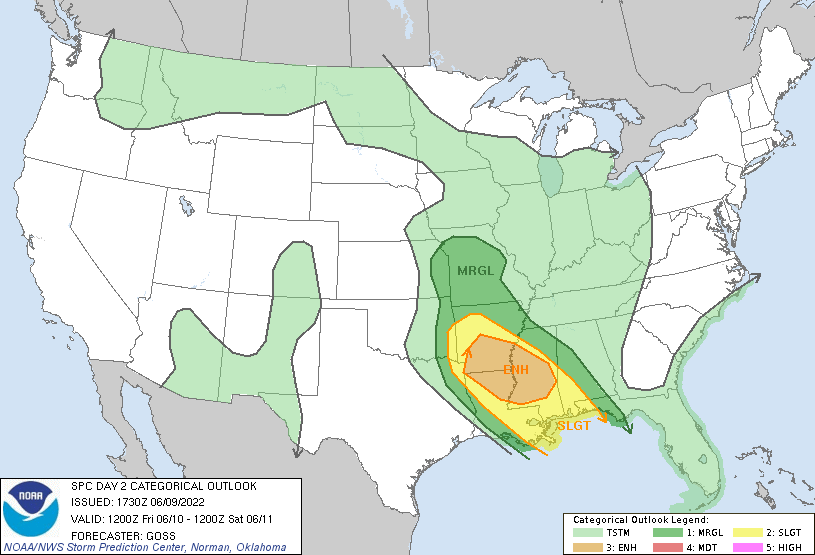
Most of you should see some gusty winds, potentially enough to blow some light unsecured stuff around. You always have to watch those side lobes curving north though. It is circled red in the picture. That’s an area where you could see some quick tornadoes and some enhanced winds. In the area the cold pool is dominating, I don’t expect much in the way of tornado threat. The big concern is wind, especially in bowing segments.
This should also yield a lightshow for everyone. I expect the lightning to be abundant and the doggies to be petrified. Make sure the pets are appropriately drugged tomorrow afternoon.
South moving storm complexes tend to deliver rocking summertime storms in the deep south.
tl;dr version
It is likely a complex of severe storms will dive southeast across Alabama, Arkansas, Mississippi, Louisiana, and a bit of the Panhandle of Florida. The primary concern is going to be strong winds resulting from the massive energy exchange of lifting that oppressive airmass upward. There should be excessive lightning to join it. Watch for bowing segments on radar, as they will have the strongest winds. In addition, southern Mississippi and Alabama should watch for quick lived tornadoes in curving segments in the line.
Stay safe and get those pictures of the approaching shelf cloud from the safety of the indoors.