Just Make It Through The Weekend: Heat Moderating Next Week
While I’ve been up in the mountains loving the weather, June has been a month of brutality for the Southeast. This week will be the high water mark on temperatures, most likely, with widespread triple digits expected by Friday. Baton Rouge, for example, has four straight days of forecasted temperatures at or above 100 between Thursday and Sunday. To keep highlighting the unusually high top end on temperatures, consider that for much of the Southeast the 850 mb temperatures will be record highs for as long as we’ve been keeping records.
This means, expect record highs to be broken across the Southeast through the weekend. Rain chances will be limited, again, as ridge remains directly overhead providing sinking air. Late July in June continues, but at least there are signs of a return to closer to normal summertime hot by next week.
Oppressive Heat Continues This Week
The beatings will continue until morale improves.

You just hate to see it. A big heat dome centered roughly over Memphis brings with it the potential for record breaking heat. The good news is that, if you’re on the eastern side, humidity values should be reasonable with the northerly flow. This will at least keep the heat index values from dangerous levels. Down toward Louisiana and Texas, humidity will also take a small step back this week but not enough to keep the heat advisories at bay.
Remember with this kind of heat to stay hydrated and take plenty of breaks if you’re spending a lot of time outdoors. The good news is folks are more acclimated after the last month, but triple digits along the Gulf Coast are rare. So don’t trifle around with the heat this week!
Days of Triple Digits To End The Week
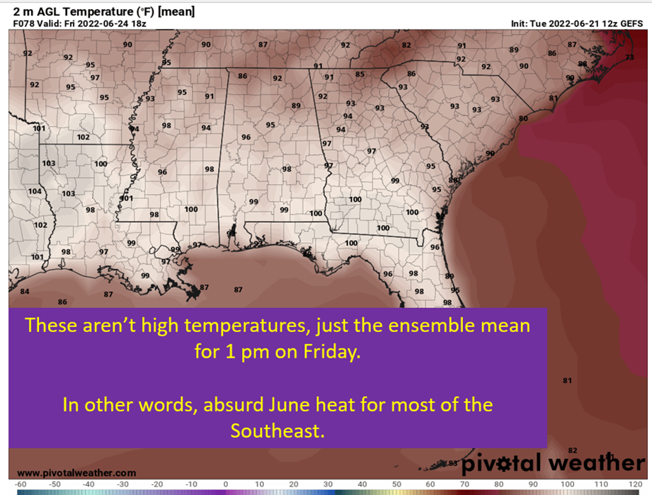
Both the GFS and European models are sitting higher than the model blend the NWS likes to use, which at least suggests temperatures might be even higher than forecast for the weekend! Which is crazy when you consider these are the NWS forecasted high temperatures for Saturday for a few locations:
- Baton Rouge: 101
- Little Rock: 101
- Mobile: 102
- Jackson: 101
- Birmingham: 99
- Memphis: 102

Rain chances will be slim but afternoon storms aren’t totally out of the question. The weekend could see some decent rain chances, though not really showing up on the models yet. At the 500 mb level, heights will actually be falling slowly through the weekend. Could imagine, with the heat at the surface, getting more widespread storm activity than global models are showing. This would put a cap on the top end of temperatures Saturday and Sunday.
I’m not certain of the above scenario, but keep it in mind for weekend plans at least.
Heat will be hitting the triple digits by Wednesday in some locations, and the heat is locked in through the weekend. Keep the pets cool and hydrated, check on your elderly neighbors, and take it easy out there. Questions of rain chances by the weekend will eventually determine just how hot those weekend days will end up being.
Temperatures (Probably) Moderate Next Week

The pattern breaks down, for a couple of days at least, as a ridge builds in the west and northwest flow brings cooler air into the Southeast. The result is a return to more seasonable temperatures, and even a dip to below normal temps. This change won’t be long lasting, as long range ensemble guidance wants to start building an eastern ridge again by next weekend. So don’t be surprised if the heat comes back heading into the holiday weekend.
tl;dr version

The punishing heat is going to continue, at least through the weekend. Expect temperatures to soar into the triple digits by Wednesday in some locations and have highs reaching 100+ each day through Sunday. There are questions in my mind, specifically on the weekend, in terms of storms cutting the top end off the temperature. Heights will be falling with temperatures at the surface still primed to reach triple digits. That sort of thing makes me think storms a bit more widespread than current modeling suggest.
Some moderation looks to come by early next week, with temperatures closer to the seasonal 90-93 across the region vs this hot nightmare.
Take it easy this week. Check on your pets and the elderly. Hydrate. Take Breaks.
That’s all for today. I do have half an eye to the tropics, will update y’all if needed. No Gulf of Mexico threats in the foreseeable future though.