
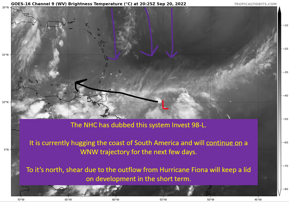
98-L: The Model Madness Continues
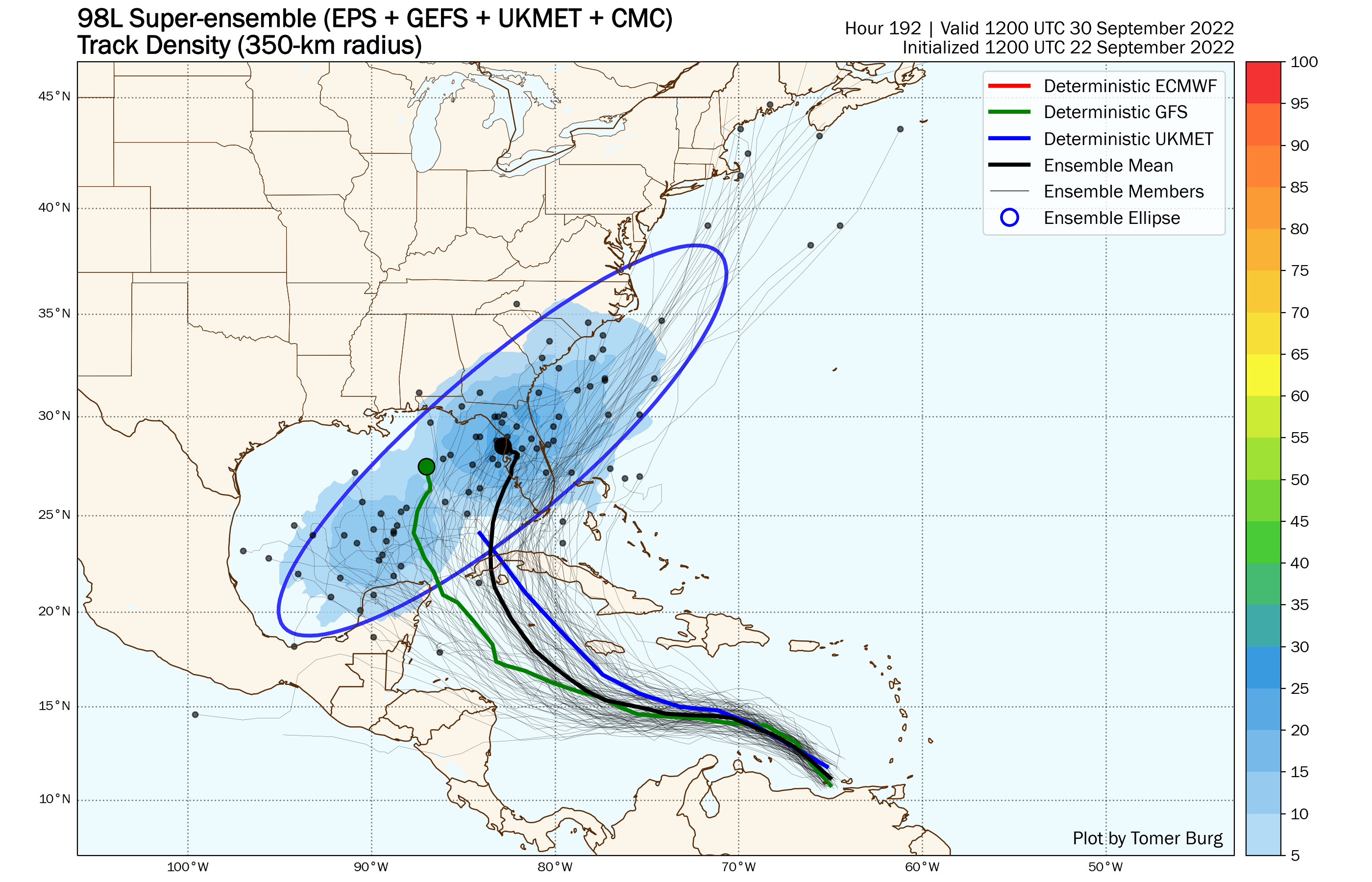
The ensemble spread remains comically wide at this point, with pretty much the entire Gulf of Mexico fair game if you believe a blend of the EPS and GEFS. The deterministic models, especially the GFS, continue to not shed a whole lot of light on the post Caribbean fate of 98-L/future Hermine/future Ian. At least in terms of landfall location. The European has at least been somewhat consistent, with Florida always being it’s target, but that target has shifted toward South Florida this afternoon.
At this point, there are two reasonable scenarios emerging and one that is plausible but unlikely.
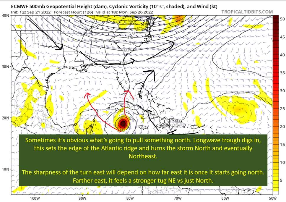
The first is this develops far enough North to feel that deep trough pull it north and eventually northeast into the Florida Peninsula or as far north as the Big Bend. It could even miss Florida entirely to the south in the most “east” iteration of this scenario. This is the most likely scenario if you ask me, but I can’t eliminate the other scenarios yet.
The second is a southern development that doesn’t get fully captured by the trough and instead gets slowly pushed north toward the Northern Gulf Coast. In this scenario, the storm would cross over the Yucatan and into the Gulf. While it doesn’t make as much sense as the Florida strike, there’s model support and a plausible mechanism of downshear formation. Just too much there to dismiss that possibility.
The last is for it to remain weak the entire time, go west across the Yucatan and eventually end up moving west into Mexico. Some ensemble members have that, so it’s got to be mentioned. I would be surprised if that happens.
That said, today let’s look at the model differences and see what it would take for each to become realities.

The GFS Has Been All Over The Place In The Last Day
The GFS has had it’s self a tour of the Gulf Coast over the past four runs. This highlights the uncertainty still on the table, but also is probably due to biases of the GFS with convection. Dr. Levi Cowan, in his Tropical Tidbit today, discussed a key difference with the GFS and others concerning where the center forms.
The GFS, with convection firing “downshear” or to the south side of the wave envelope, has a vort (area of spin) spin up on the south side and that ends up rolling up into the center of the storm. There is a sister hurricane specific model that runs on GFS initial conditions, the HWRF. It ends up having the storm keep with a vort on the northern side of the envelope, and this ends up farther east as a result.
That’s a little detail, but it makes a big difference in what the eventual model landfall result is.

It makes the GFS’s method genesis methods dubious when you see it do things like the above. The problem is…
Having Center Reformations To The South (Early On) Wouldn’t Be Strange
What shear does is that it ends up tilting the system from vertically aligned. The higher parts of the storm get pushed whatever the direction the shear is pushing. In this case, the shear is mostly from the NE, so the storm would have a surface center to the NE and a mid level center to the SW of that. In effect, it blows thunderstorms away from the center.
When this happens, the rising air within the storms can lead to the formation of it’s own area of spin. In immature and developing storms, that new area of spin can end up becoming dominant.
In short, what the GFS is doing by firing new centers off that sheared convection isn’t unthinkable. Hell, I’ve seen it happen on numerous occasions. It is something interests along the Northern Gulf Coast need to watch for, as this scenario could allow for the trough to not fully capture it.
We Have A Structure Question, Good Time To Turn To The HWRF

If I’m worried about the structure of a storm and how it forms, why not turn to the model that handles that stuff the best?
It ends up north of the GFS, despite importing the same initial conditions, and this is a position that would put Florida at threat. This is in line with what the European model is doing as well. I think this ends up being closer to reality than the GFS has been, and it’s a large part of my thinking that this will end up being a threat to the Florida Peninsula.
I do have to keep saying that the Northern Gulf Coast needs to still pay attention. Most likely doesn’t mean “will happen”.
If There’s Good News, It Is That We’ll Know The Answer Soon

Watch the above and pay attention to the deep thunderstorms on the south side of the system. Those convective bursts are what the GFS would hypothetically be seeing that end up tugging the center that direction and away from the mean WNW movement. If this is happening, we’re going to notice it over the next two or three days. The center will be farther south, and the models will follow it.
On the other hand, if these bursts don’t end up dragging the center south, it should end up more like the HWRF/Euro position just a little south of Jamaica. Once again, it should become more apparent as time goes on that the southern solutions don’t hold weight if the center continues well north of that. We’ll see the GFS respond in that short range and come back east.
I don’t know the answer, but we’re at least getting to the point where the first big question will be answered by the end of the weekend at the latest.
tl;dr version
We’re at the frustrating point where we know the questions we need answered, but it is not time for the answers. The GFS has been the west outlier, in large part due to that downshear formation discussed earlier. It has been coming back toward the European solution this afternoon, and I think that trend should continue. What we’re waiting for is it to hit about 75-80 W. At that point, we’ll have a true center and a much clearer idea of where it is going to end up.
Where it starts is going to matter greatly to where it eventually ends up.
There are two main scenarios I’m watching for:
The first is for this to form far enough north to get turned NE and go across Florida.
The second is for this to form farther south, miss getting fully captured to the NE, and move toward the Northern Gulf Coast.
The Florida scenario still is the most likely in my mind, but we can’t sleep on the second scenario yet.
That’s all for today. Tomorrow, I’ll finally get around to talking strength. I think.
2 thoughts on “98-L: The Model Madness Continues”
Comments are closed.
Related Posts
Tropical Storm Ian Churns in Caribbean As Models Shift West
It’s Officially TD9, And The Models Are Targeting Florida
Getting To Know The Steering Players For Future Hermine
Invest 98-L With High Chances of Development
Danielle and Earl First Storms In Atlantic In Two Months
Still Watching Caribbean For Tropical Development
Watching The Caribbean For Tropical Trouble

The Tropics Appear Quiet For Next Couple of Weeks
A Brief Cooldown In The Southeast And Watching The Tropics
October 11, 2022 at 5:41 am
Top site ,.. amazaing post ! Just keep the work on !