Hurricane Ian To Make Second Landfall In Carolinas
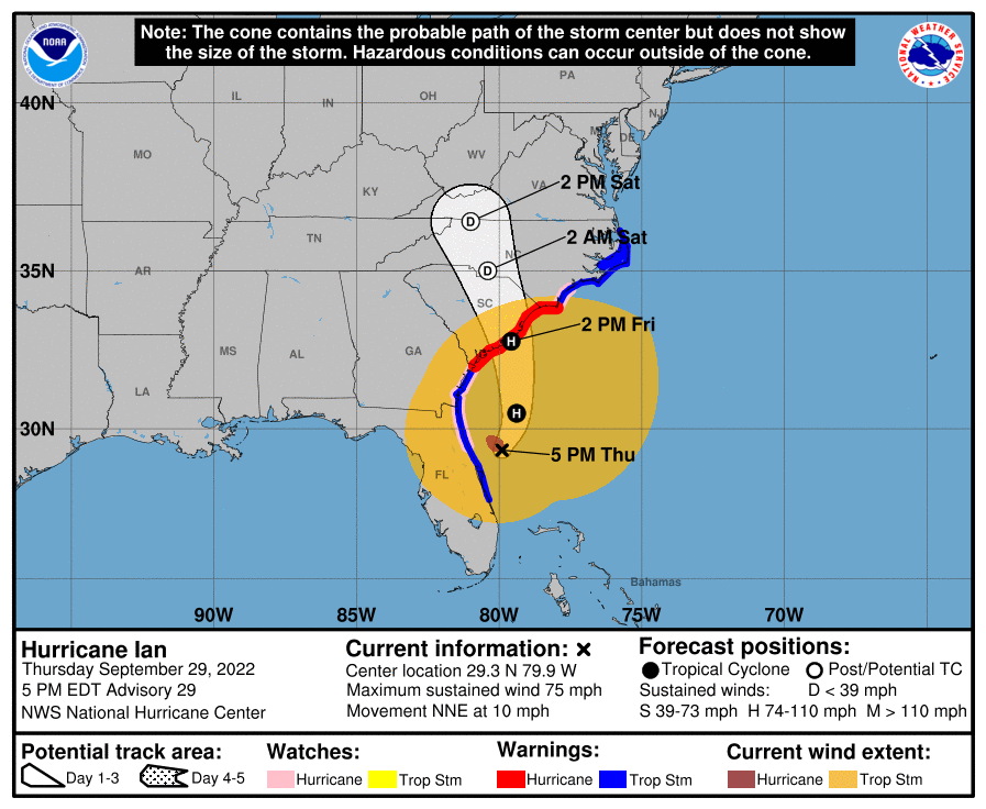
Ian’s relentless path across the SE is going to continue into the weekend, with Georgia and the Carolinas in line.
Ian won’t return to Category 4 strength, but has a favorable jet interaction that will probably facilitate some mild strengthening. The main threat is going to be from the storm surge and rain, especially in the Low Country of South Carolina. That said, power outages are likely along the path of this hurricane and folks in the region should get some hurricane supplies, just in case you’re out of power for a few days.
Those closer to the coast should pay close attention for track changes and listen to your local officials for evacuation information.
I’m ready for a nap, but Ian isn’t ready for sleep just yet.

Upper Level Jet Positioning Allows For Ian To Re-Strengthen

The position relative to the upper level jet is probably what let Ian have that surprise intensification Wednesday morning. I missed it and I’m still kicking myself for it. That made an already deadly surge scenario that much worse.
This positioning has continued and will allow for Ian to strengthen some despite extremely atypical presentation for a hurricane. The same upper divergence that helps severe thunderstorms pop also help hurricanes to strengthen. It should be slow with Ian, since the inner core was totally disrupted over Florida, but could push 85-90 mph by the second landfall.
So don’t sleep on the winds, especially if you’re closer to the center.
Ian’s Size Will Bring Substantial Surge To The Carolinas, Despite Low Category

This image is usually aggressive with how far out it spreads the winds. Don’t worry about that so much, just see how big the space the NHC shows is. What this means is sustained onshore flow for Georgia and the Carolinas, at least until Ian has moved north of your latitude. Those in Charleston need to be ready for a prolonged surge event with 4-7′ expected across most of the South Carolina coast. These big storms cause surge problems outside of their category expectations.
The most at risk for the highest surge would be just to the north of where landfall occurs. The headaches from Ian, and the potential for life altering surge continue.

Flash Flooding Potential Remains North Of Track

This scenario is an obvious one for flash flooding. You got higher terrain to the west with onshore flow and a favorable synoptic position for lift. With the expected loose organization, there won’t be the same focus for excessive rainfall as Florida saw. Those close to the coast should also consider where they drain to. If it’s out to the Atlantic, onshore flow will push water up the rivers. This will slow your drainage down and make the flood threat higher for the rainfall.
I know the surge and the wind get all the attention with a Hurricane, but freshwater flooding is just as dangerous and a much more widespread threat normally.

tl;dr version
As Florida begins to wrap it’s head around the recovery to come, Ian has moved on to threaten Georgia and the Carolinas.
Despite a sloppy appearance, upper level positioning will allow some strengthening of Ian before landfall late Friday/Saturday, most likely in South Carolina. The wind isn’t going to be extreme, with 80-85 mph most likely. The main story will be surge, once again, especially for the Low Country of South Carolina. Don’t sleep on the inland rainfall, and the power outage potential in the Carolinas either.
That’s all I can muster today. I need a nap, as I’m sure all of y’all in Florida do too. Stay safe all.


