One For The Mardi Gras Skiers

Sitting, drinking a cup of Yorkshire Tea (have yourself a “Proper Brew”) at Copper Mountain, checking on the ski weather for the next couple of weeks.
Since I know many from the Gulf Coast make a journey up into the mountains around Mardi Gras to ski, I figure why not make a post looking at the potential snow coming up for the Rockies. The story out here is going to be the opposite of the Gulf Coast going forward. After a week of relative warm out here, and a cold snap for the first weekend of Uptown parades, things are going to flip around.
Multiple storms will swing through the west over the second half of February, delivering the promise of soft turns for those coming to the frozen west.
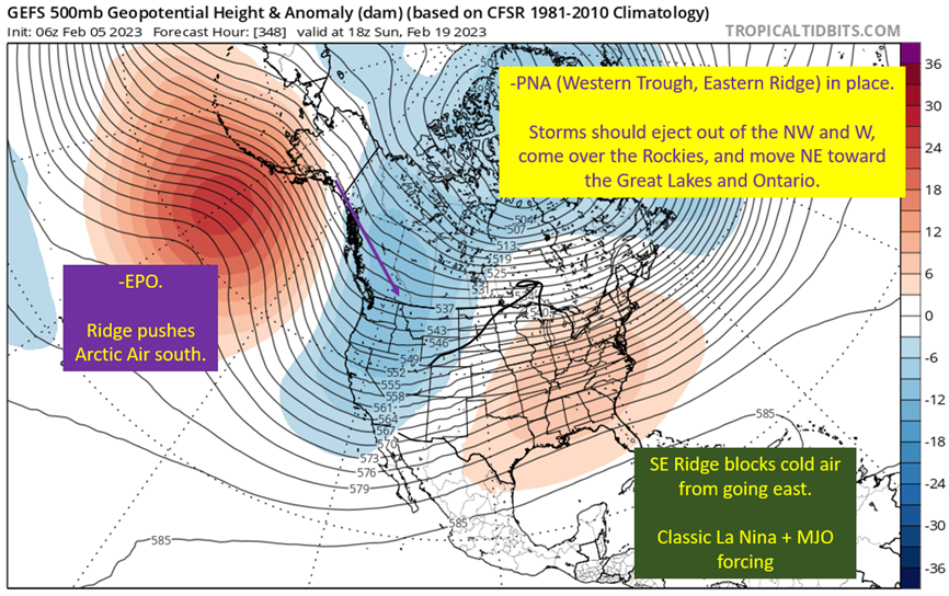
Sub-Seasonal Factors Demand Western Troughing

This is a bit of a long story, but an interesting one (potentially to literally just myself).
After a January with the jet stream ripping across the Pacific, bringing abundant moisture to the west, the pattern wants to revert back to December over the Pacific. Which, makes a lot of sense, given January was textbook El Nino (firmly in a La Nina still) and this February pattern fits the La Nina expectation.
The change started with a large negative East Asian Mountain Torque (-EAMT) event during the later part of January. The cause of this was numerous low pressure systems forming on the lee side of the mountains of Asia. This put a high pressure to the west, low pressure to the east, and forced the winds to blow with the spin of the earth. This reduces overall atmospheric angular momentum.
No! Wait! Don’t run away. I promise this is worth your time, and there will be no math.
Angular momentum is conserved, so the jet stream responds to this drop in angular momentum by slowing down. This causes it to “retract” and basically pull up into a ridge over Alaska and the northern Pacific.
That ridge forces cold air south into the western United States.
A Little Kick From The MJO for the Southeastern Ridge

I wouldn’t just consider the MJO to help support that Southeast ridge, but with La Nina on and western/greenland troughing, the MJO effect should just farther re-enforce the ridge and let it build farther north into the Eastern United States over the month of February.
The gist here is that the sinking end of the MJO should be over the Caribbean, and this should help keep that ridge flexing in the eastern United States. Makes the storm track pretty obvious across the second half of February.
Systems will push off the Pacific from the NW or W into the American Rockies. Will see some low pressures form on the lee side (east) of the Rockies, and cut NE toward the Great Lakes. Proximity to these storms, and wrap around moisture should deliver numerous shots of snow over the mountains from about the 15th of the month on.
Models Are Seeing The Snow Coming

The GFS ensembles are showing exactly what I’m talking about above.
About halfway through the run, we have modest snow totals across the west. Then, as it gets into the second half of February, the snowfall totals explode. You can also see how the snow totals increase to the NE over time too, with Texas getting a pittance. It’s always nice when you’re idea ends up playing out on the models.
The short story, looks snowy for you Mardi Gras skiers.
For The Bad News: Its Gonna Be Cold
I’ve gotten to enjoy at least 15 days of mornings below -2 this year, and that certainly looks to increase with the coming pattern out west.

Michael Scott, do you have any thoughts?

That January pattern I mentioned earlier? It was awesome. A few heavy powder days, but also temps in the 20s during the day and maybe single digits at night. Not to cold, plenty of snow, it’s what you want in ski country.
This coming pattern should be snowy, but it’s gonna extract a price with the cold.
Nothing is popping off the map as ridiculously cold, but it’s so far away that it wouldn’t show up just yet. The potential is there for some very cold mornings within the intermountain west through the end of February. So pack those thick base layers.
tl;dr version
A cold and snowy pattern should emerge across the western United States over the last half of February. I was definitely grinning ear to ear checking the ensembles this morning…
Well, until I decided to check in on those temperature anomolies.
This pattern will make for some great ski/riding trips out to the west, from Crystal Mountain in WA all the way down to Taos. Just make sure you bring the cold weather gear, since there will likely be a couple of very cold days on any late February ski trip.
That’s all I got for today. Next morning I get some free time this week, I’m going to dig into the weather for the coming weekend’s parades. Spoiler alert, it’s actually gonna be chilly.


