Gulf Low Will Bring Rain and Coastal Flooding

Ski season is starting to ramp down as Spring arrives in the mountains, so I might have a little more time for this going into the summer.
That, and the doctors frown upon me skiing with a shoulder fracture. Cowards.
I guess I should turn my eye to the weather in the southeast. A very interesting scenario is unfolding, with a pretty strong upper low getting ready to “cut off” from the flow and park near the TX/LA line. The parent trough is still strong and will continue to push to the east and southeast. The cutting off process will lead to strong divergence aloft between the two features, and this will cause a surface low to form near the Louisiana coast.
The result? Potentially heavy rain. Windy conditions. Oh and a fair bit of coastal flooding.
Let’s jump in.
Divergence Aloft = Mass Removed From Surface…Low Pressure Forms

What’s happening aloft is there is are two areas of higher wind velocities. One will be around the cut off low and the other max around what’s the left of the upper trough as it bounces out to the SE. In between will be an area of light winds, showing that mass is being pushed out in all directions, instead of being forced together (as in high winds).
Imagine the atmosphere as a column of air, and remember that mass is conserved (what goes in must go out). With a bunch of air leaving the top, you have rising air and it’s forcing air into the bottom of the column. This, my friends, is a great way to form a surface low pressure.
Heck, you can think of pressure as a representation of how much stuff is in the column of air. Less stuff, because it’s being evacuated out the top, lower pressure.
Results: Wind, Rain, and Coastal Flooding But A Lot Depends On Track

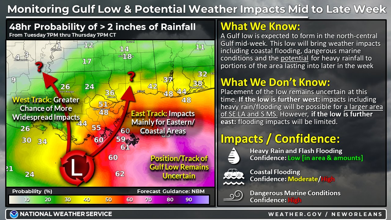
You might have noticed the size of the circle in the previous paragraph, showing the upper divergence. We know a low pressure is gonna form in the general area, but where it forms exactly and where it goes matter for Louisiana impacts. Well, at least those away from the immediate coast.
As you can see in the NWS image, if the low tracks farther east, it will mean less rain and flooding impacts away from the coastline. A farther west track would bring those high rain chances out in the Gulf farther west into Louisiana. So the potential for heavy rain is there, but there’s no guarantee.
No matter what, it’s going to be very breezy with a strong pressure gradient forming. This is why the confidence of the coastal flooding is as high as it is. This scenario of a slow moving surface low will keep an onshore fetch going for days.

Areas warned obviously need to pay attention and prepare for inundations from 1-3′ above normally dry ground. Y’all know your areas, and know what these sorts of events will do in your neighborhood. So be smart, don’t drive into flood water, and get your stuff to higher ground. This will also be a fairly long duration event (2+ days), so don’t expect the water to just come up and come back down.
tl;dr version
Yeah, it’s a short post today. I’ve got to get my bloggin’ legs back under me. Plus, there isn’t much catastrophic risk here. Great event to get my feet wet again.
Anyway, we have a classic case of upper divergence leading to the formation of a surface low. It will form somewhere near the Louisiana coast and track kinda north, with questions to how far east or west it gets. Those questions are important for Louisiana impacts, since East means very little but coastal flooding and west opens up the flash flooding potential.
No matter what, coastal flooding is going to be issue along the SE Louisiana coast until this system finally moves away by the end of the work week.
Y’all stay safe, and I’ll be back with another post soon.


