The 2022 NOAA Hurricane Forecast: Above Average Season To Come
The Rundown
NOAA released their annual hurricane forecast for the Atlantic basin yesterday, and no surprise, it is expected to be busier than normal. The reasoning is with La Nina continuing, there will be lighter trade winds and warmer waters in the Atlantic. In addition, the West African Monsoon is expected to be stronger than normal. That monsoon circulation is a common source of tropical waves coming off Africa. Lower shear, warmer water, more tropical waves. That’s a recipe for a more active than normal season.
It is important to remember a couple of things about these seasonal forecasts.
- This is not a forecast for landfalling hurricanes. Just for the number of storms in the basin generally.
- There is not a 100% chance of a more active season. NOAA, like the good forecasters they are use probabilities of outcome.
So today, going to show you the current state of the ocean temperatures. Then pull some analogs of past seasons that most resemble the set up this year. Finally, I’m going to discuss a few new products that will be live during the hurricane season from the NWS. Let’s jump in!
Heading Into June: Subtropics and Gulf of Mexico Warm

The Main Development Region (MDR) is circled in violet. This region gets its surprising name by being the region where most tropical systems form in the Atlantic. Warmth in this region is a good signal for an active season. The Caribbean side remains cool, as are the waters off the west coast of Africa. There should be periods of lighter trade winds over the region in June, which would allow the surface temps to warm due to less mixing with cool waters below.
The Gulf of Mexico is warm for this time of year. Yay!
Sigh
Also, note the warmth in the subtropics. There’s a lot of energy for recurving systems to eat. Could be yet another year of a couple of pretty hurricanes over the open waters of the Atlantic and an explosive extratropical transition or two.
Analogs: What Seasons Started Like This One?

Don’t take this to be “there will be more hurricanes in the red shaded areas”. It just shows where hurricanes are more frequent in a similar year. It doesn’t mean one will happen.
This took the five most similar seasons to this one at this point in time and plotted how frequent tropical systems passed through an area. The more frequent than normal areas come as no surprise. The Gulf of Mexico and western Caribbean, which I don’t care for one bit. There have been too many waves over the past five years or so that struggle until they get into the western Caribbean and then hit the gas. There’s no escaping out to sea when that happens.
The Subtropical Atlantic also collects a lot of recurves in years similar to this one. Lots of warm water and a tendency to have rising air over that warmer water. I’ll get into each one of the analog seasons as the summer goes on.
Once again, it doesn’t mean the Gulf of Mexico will get a bad hurricane this year. It just means we have to watch that region in the western Caribbean awfully closely.
NHC With New Products, HWRF/HMON, Hurricane Drones
The big story for me is the NHC/NOAA are going to measure the boundary layer where the ocean and sky meet. They will be operating unmanned drones, ships and hurricane gliders. Along with Hurricane Hunter aircraft, this should yield data that a few PhDs could be built upon.
Read more about the hurricane research ongoing in 2022: Right Here
NOAA has access to more supercomputing space this year and this means the HWRF and HMON get a home on the newest Weather and Climate supercomputing system.
Finally, the NHC will issue updated Peak Surge Forecast images this year. The product is still experimental. In addition, the WPC will be issuing experimental Excessive Rain Outlooks (ERO) out to day 5 this year.

tl;dr version
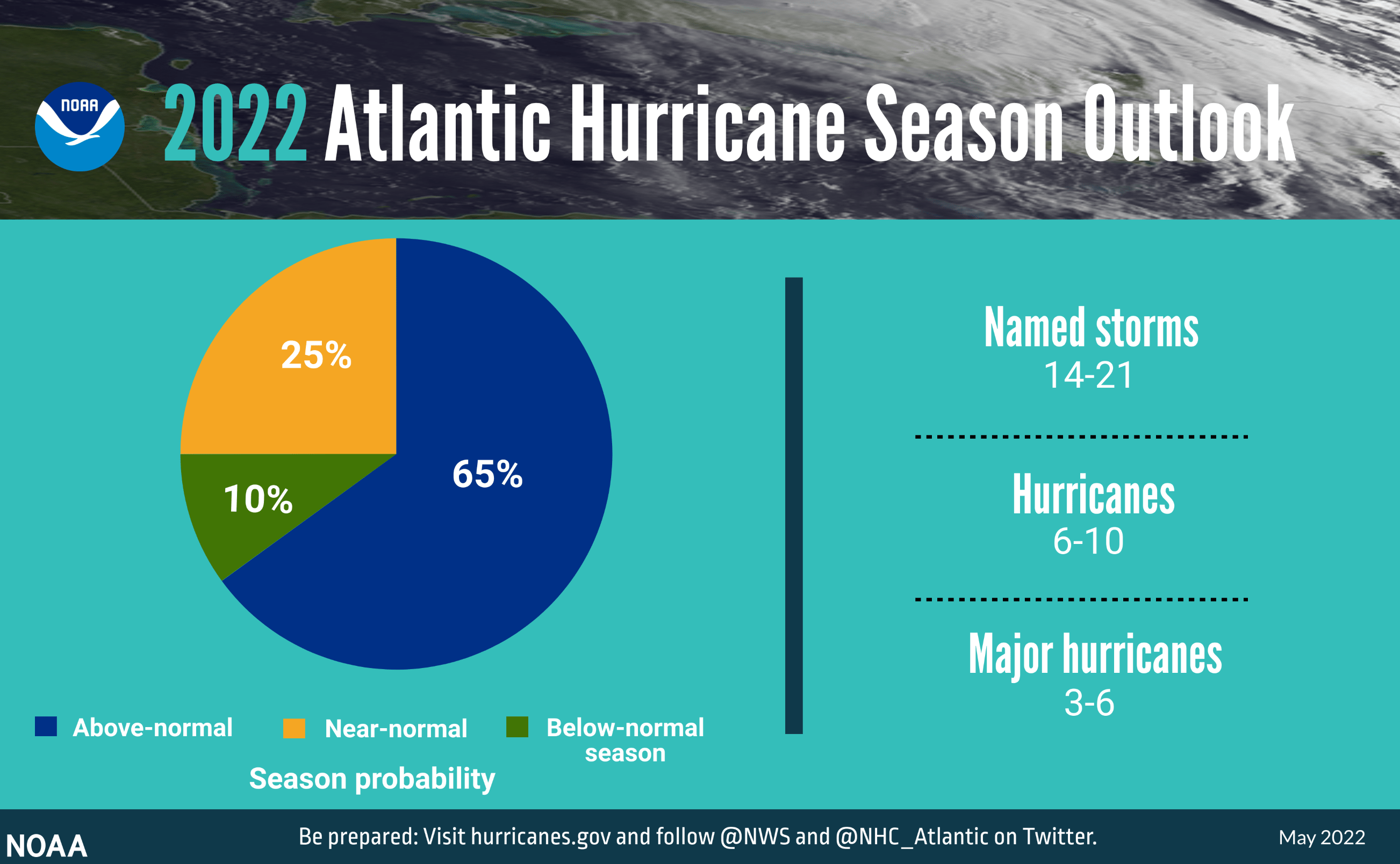
NOAA is forecasting higher probabilities of an active hurricane season as compared to normal and less active. In other words, they have a 65% chance of a more active than normal Atlantic hurricane season. This is based on the expectation of La Nina conditions to continue through the season. La Nina bring warmer ocean water, and lighter shear overall. In addition, an active West African Monsoon will likely provide more frequent and strong tropical waves.
In years similar to this one, hurricanes were more frequent in the open Atlantic after curving off the United States east coast. In addition, the western Caribbean and Gulf of Mexico tend to be more active. I really hope that doesn’t end up being the case after the past few years.
Finally, the NHC has big plans for hurricane research this year. They also got the HWRF and HMON on the fancy supercomputer and will have some experimental products for surge and rainfall this season.
That’s about it. Enjoy the last weekend of not being in hurricane season.