Let’s Get Weird. Agatha In The East Pacific Will Be An Interesting One To Watch
The Rundown
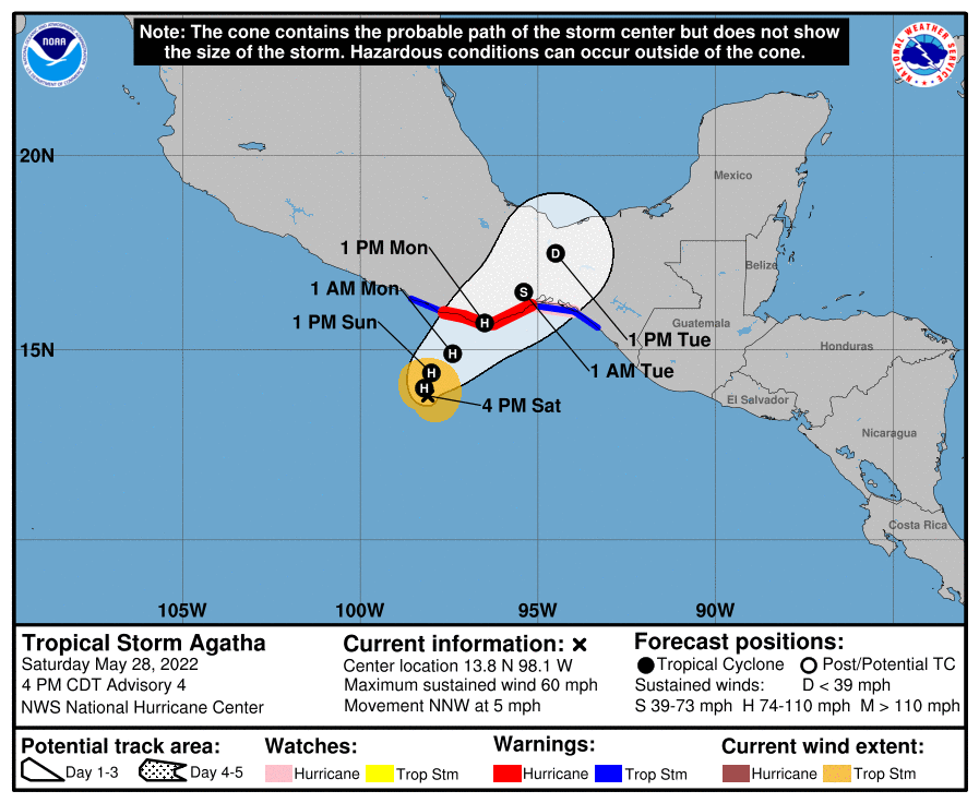
Tropical Storm Agatha is the first tropical system of the Eastern Pacific season. The storm is expected to strengthen rapidly over the next 24-36 hours and landfall in Mexico. NHC forecasts the winds to reach 105 mph by landfall. Then Agatha will be torn at by the rugged terrain of Mexico before whatever is left ends up over the Gulf of Mexico.
I’m not going to focus on much after Monday night. I will hit on what ensembles are showing at the end of the post. The primary focus today is on the short term situation for Agatha and how it should develop over the next day and a half.
Getting Some Situational Awareness

At the time of me writing this, Agatha is a tropical storm with maximum sustained winds of 60 mph. Agatha has recently had a round of deep convection around the center. Curious to see how long that will last, but conditions are favorable ahead so this could be the start of the expected strengthening. Looking at water vapor imagery, Agatha looks a little squeezed on the west side but outflow is expanding overall this afternoon.
Makes sense as conditions until landfall will be conducive to strengthening of Agatha.

Current Structure: Agatha Getting Act Together
Satellite images show a persistent central dense overcast feature and curved bands that wrap about halfway around the center. An ASCAT-B pass from about 16Z showed peak winds of 40-45 kt. More recently, the Dvorak classifications range from 45 to 55 kt.
NHC Agatha Discussion Number 4
The NHC notes the latest microwave pass shows Agatha has a curved bands forming. The inner band will eventually wrap around the center and produce the eyewall/core of Agatha. The waters ahead for Agatha are very warm, which will support strengthening. Overall shear is low around Agatha. This means a major hurricane is not out of the question with this one.

Agatha To Drift Into Southern Mexico

Agatha is currently in a regime of weak steering, only moving 5 mph to the NNW currently. Agatha is going to mostly drift generally northward over the next 12-24 hours. Eventually Agatha will get pulled into the easterly flow to it’s north and move NE by Monday and landfall in Mexico.
Summing It Up
Agatha is going to keep strengthening until landfall on Monday. There are nearly ideal conditions ahead of Agatha. The water is warm. The shear is light. The upper levels are supportive. Somewhere in that 100-115 range seems likely. It is worth nothing the HWRF is getting the storm stronger than this. So there is upside from that 115 range. The NHC currently has the forecast at 105 mph.
Watching The Leftovers – Will Cross into Gulf of Mexico

No need get too worried at this point. I just want to note the potential of Agatha crossing over into the Gulf of Mexico. There is limited ensemble support for this scenario but there’s enough to say it’s worth keeping an eye on. There isn’t likely to be much left after it crosses the rough terrain either.
tl;dr version
Tropical Storm Agatha is currently off the southern coast of Mexico with winds of 60 mph, per the NHC. The system is expected to drift this evening and most of the day tomorrow before turning toward the NE. The period from now until landfall has the storm traversing warm waters with light shear. In addition, the upper levels are venting the storm well already. I wouldn’t be surprised if this ends up stronger than the NHC forecast of 105 mph. The storm will make landfall on Monday evening and the remnants will eventually enter the Gulf of Mexico by the middle of the week.
Still significant uncertainty with any Gulf of Mexico development, so I’m not worrying much about it today.