
Tuesday Severe: Boom or Bust
Rick Smith, Warning Coordination Meteorologist at NWS Norman, put it best on twitter this afternoon.
“Conditional: subject to, implying, or dependent upon a condition.
Tuesday’s severe weather potential is HIGHLY conditional, and the condition is that we see storms form at all.”
Give @ounwcm a follow, he’s a great meteorologist.
This really gets to the heart of the Tuesday conundrum. Strong shear with high instability, the high end tomorrow is about as violent as it gets but there are significant questions if we see storms at all in the eastern Plains. The convective allowing models all just don’t fire storms as of this afternoon, except in Iowa close to the surface low and some fire down into Texas along the dryline. There will also be some lead storms across SWLA/SETX as I’ve mentioned in a couple of posts now. Right now, the shear profiles aren’t all that great down that way from the convective allowing models. Which, is good news, as hopefully there won’t be much severe over that way.
Today, we’re going to go top-down again looking at late afternoon tomorrow. All of these features will be shifting through the day, so don’t focus exactly where I circle. I do find it useful to highlight the pieces and where the questions will be.
Y’all ready? Let’s hit the jet stream.

The 12z GFS from 4/11/22, showing 300 mb winds and geopotential heights. Image from pivotalweather with annotations by Jacob Caddell.
It’s messy. There is some helpful divergence for storms over eastern Kansas, Nebraska, western Missouri, and most of Iowa but it is not jumping off the screen obvious. Further south, there’s actually a little convergence going over eastern Oklahoma and into Arkansas. It is not enough to necessarily stop storms from firing, but it doesn’t help. Additionally, there’s a nice bit of divergence over the Dakotas which supports the idea of the blizzard expected on the cold side of this system.
Next, I’m going to look at 500 mb level. There are two areas of interest there, with a broad section of cyclonic vorticity over the eastern Plains and Iowa and another to the south over SETX/SWLA. Since the lifting mechanism isn’t totally obvious after looking at this level, I’m going to use some QG analysis to look for the areas most likely to have ascent for storms following the straight up 500 mb winds and geopotential heights.

The 12z GFS showing 500 mb winds and geopotential heights. Image from pivotalweather, with annotations by Jacob Caddell.
This shows the two main areas of interest tomorrow, though the severe risk in green will be present farther south into central Texas as well. The southern one will bring storms and rain into SETX/SWLA tomorrow afternoon and evening. Then the large area from the northern stream is setting up the severe potential for the eastern Plains. The questions on the Plains setup are mostly thermodynamic, which I will get to later in the post with some sounding analysis. I do think with the potential being so conditional on storms even firing tomorrow, it is useful to look for where the best synoptic lift could/should actually be.
That gets us into the scary world of Quasigeostrophic Omega (there will not be math, I promise). This theory tells us that areas with warm air being pushed in and increasing cyclonic vorticity with height lead to large scale (horizontal not in terms of magnitude of the lift) vertical motion.

Image shows DCVA from the 12z GFS on 4/11/22. Image from Dr. Shawn Milrad’s Synoptic Plots Page with drawings by Jacob Caddell.
Without getting too deep into the QG theory, green means support for rising motion and brown is support for sinking motion. In general, this shows support into the eastern Plains and Iowa along with Missouri, Arkansas, and into the deep south. There is forcing for sinking air over the middle Plains and into central Texas.
This is not the only piece though, as warm air advection must also be considered. As you’ll see, sometimes they will be opposed (Texas and Oklahoma). Sometimes one piece just wont be there (most of Iowa), and sometimes they both line up. I must also note that, in general, this isn’t going to show a substantial amount of forcing for ascent.

Image showing thermal advection at the 700 mb level (standard level for QG omega analysis). Image from Dr. Shawn Milrad’s Synoptic Plots Page with annotations by Jacob Caddell.
Like I said, it does not always line up right. What it does suggest is that Iowa will be the best potential to get storms tomorrow. There is still potential in the eastern Plains, just not as much ascent. It is tricky into central Texas, at least at this point, as warm air advection is fighting the DCVA. It will need the dryline to provide some surface level lift for storms to fire that far to the south.
Alright, let’s get into the low-levels.

The 12z GFS from 4/11/22, showing 850 mb winds and geopotential heights. Image from pivotalweather with annotations by Jacob Caddell.
This part is short and sweet. There will be a low-level jet situated over the eastern Plains and Iowa tomorrow evening, which is where the low-level shear is likely to be maximized. In addition, there’s another pocket of higher low-level winds associated with the southern shortwave that will provide some help for low-level shear.
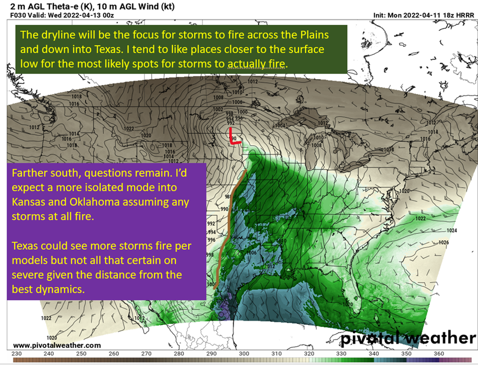
With all of this, it’s time to look at the main surface players. There are two, a strong low pressure that will be moving into the Dakotas and a lengthy dryline stretching from Nebraska into Texas.

The 18z HRRR from 4/11/22, showing theta-e (think energy content of the air) and wind barbs. Image from pivotalweather with annotations by Jacob Caddell.
The dryline is a density difference, with dry air being more dense than moist air. This acts as a boundary to focus convergence and provide some lift at the surface. It isn’t like a cold front undercutting and forcing storms up, it’s a lot more subtle of a forcing mechanism. That’s the trouble in the forecast and why there’s so much bust potential. It is not a given there will be enough from the dryline to overcome the cap expected to be there. The NAM and the HRRR both want to fire storms along the cold front later in the evening but don’t fire storms except in Iowa. The thing is though, we have a plausible mechanism to fire storms and a generally supportive upper level set up too. On top of that, the instability and shear will be plenty to support strong supercells.
Finally, checking a model sounding or two to both show the strong parameters and why there’s such potential for nothing to happen.

A model derived sounding from the 18z HRRR on 4/11/22, for a location in eastern Kansas. Image from pivotalweather with annotations by Jacob Caddell.
It’s got all the low-level shear you could want (or not if you live there), a very unstable profile (mostly), very steep lapse rates helpful to support large hail but that pesky cap above 850 mb does not want to break on the models. This leads to nothing firing until later as a line of storms push into the region with the cold front that’s coming. Like I said, high potential for strong tornadoes and large hail and high winds but with an awful lot of potential to do nothing if that cap doesn’t get worked away. These days are tricky for the models too, and it’s a reasonable possibility they have the cap overdone and storms do manage to go up. You can’t let your guard down when the impacts could be this high. You have a plan for if you get a tornado headed your way, and execute it if it does materialize.
Finally, I want to check in with a sounding in central Louisiana tomorrow evening, to show there will be severe potential there too. What is lacking is the low level shear, which is marginal for tornadoes but otherwise the profile is generally supportive of strong winds from the strongest cells and I can’t rule out tornadoes.

A model derived sounding for a location in east-central Louisiana from the 18z HRRR on 4/11/22. Image from pivotalweather with annotations by Jacob Caddell.
The basic story is there is severe potential, including tornadoes with the convection across western and central Louisiana tomorrow evening. It won’t get the hype of the Plains set up from weather people, but you don’t need hype for severe storms. Just the right shear and thermodynamic profiles. I’m not expecting widespread severe weather in the region, but don’t be surprised to see a tornado warning or two along with severe warnings, despite not being in the enhanced (3/5) risk zone from the SPC.
tl;dr version
A conditional risk of severe weather exists from Iowa down into central Texas along a dry line tomorrow as a powerful trough ejects from the Rockies. The important condition will be “do storms materialize or not”. If they do, the potential is high end but there are significant questions as to the cap breaking. These severe storms would most likely be isolated from Kansas south, with a little more potential in Iowa due to proximity to the surface low and slightly better forcing for ascent around there. Eventually a linear mode will take over into the overnight associated with a cold front diving SE and severe storms will also be possible in that line. It’s a boom/bust day for the eastern Plains.
Farther to the south into southern and western Louisiana and parts of far east Texas, there will be another disturbance moving through the area. It’s not full of the impressive dynamics of the Plains threat, but there will be a severe threat associated with that one too. Convective allowing models are firing storms down in this region, and while tornado parameters are marginal, hail and strong winds are certainly possible in the strongest storms. In addition, there could be a couple of short lived tornadoes within the strongest updrafts across this region. Won’t get the same hype as the Plains, but it’s also more likely storms actually happen down this way.
Do note this potential for severe extents into the Baton Rouge metro as well.
Tomorrow, it’s another top-down adventure looking into the Wednesday potential across most of the Mississippi and Ohio Valleys. That’s all for tonight, stay safe out there, especially in Arkansas were severe storms are currently on-going.
Related Posts

Hurricane Season 2023 Preview: El Nino Returns

Gulf Low Will Bring Rain and Coastal Flooding

One For The Mardi Gras Skiers

Bust Out The Shorts For Mardi Gras

Hope You’ve Enjoyed Fall So Far. Looking Ahead At The Big Picture Into November.

The Media Coverage Of Ian Has Been Frustrating

Hurricane Ian To Make Second Landfall In Carolinas

Hurricane Ian Strengthens and Grows Larger With Landfall Tomorrow

NHC Forecasting Near Nightmare Scenario For Tampa
