Very Active Late June In The Tropics
La Nina coupled with a Convectively Coupled Kelvin Wave (CCKW) have yielded exceptionally friendly conditions for tropical development in late June. Abnormally low shear across the Main Development Region (MDR) and into the Caribbean stands out in an upper level set up more like that in late July and August. The InterTropical Convergence Zone (ITCZ) is busy with a wave train stretching all the way back to West Africa.
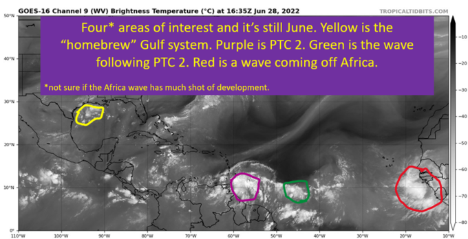
All of this comes together to provide for a likely Bonnie to form in the next few days and take a very far south track near South America and eventually driven into the heart of Central America.
In addition, there’s decent homebrew potential currently off the Louisiana coast. It too will be pushed west and potentially bring some rain into Louisiana and Texas. It will not have time to develop into much more than a rainmaker.
This is lengthy enough that I think a table of contents is useful:
- Upper Level Pattern: Steering and Shear
- Wave Train From West Africa
- Low Latitude Moisture
- Track and Intensity for future Bonnie/Colin
In addition, the Gulf Coast Mischief.
Steering Across The Atlantic: One Way Traffic To The West

Sometimes it is pretty simple, and this is one of those cases. Ridge will build in toward the west and bring the heat back over the Southeast. The clockwise flow around the ridge will keep PTC 2 moving west and eventually WSW as the ridge builds in front of it. Chances are slim to none it manages to round the edge of the ridge before it builds in above it. This will force a storm track near or even along the coast of South America and eventually burying it in Central America. The current NHC path takes PTC 2 through a region that doesn’t experience many tropical cyclones, being as far south as it is.
Same story for the little spin in the Gulf I’ve mentioned, it will be pushed west toward Texas as the ridge once again builds in over the Southeast.

A Peculiar Lack of Shear
It is a very unusual look for June to see such low shear in the Caribbean, especially over the eastern Caribbean. The passage of the CCKW was well timed for PTC 2, leading to a decrease in shear in a La Nina environment already presenting lower than normal shear. The result is an upper level environment that will be conducive for development. In a summer where June has felt and acted a lot more like July, I guess it shouldn’t surprise the tropics also look more like early August than late June.

Tropical Wave Train From Africa: Engaged
This is the other unusual bit for this time of year, the wave train from Africa is very active. This certainly isn’t what I want to see come August. In June, if everything comes together just right you’ll get a hurricane and a weak tropical storm off of this pattern. In the heart of the season, this is the makings of a hurricane outbreak across the Atlantic. Just look at the water vapor of the tropical Atlantic. I’d forgive you for thinking it’s August looking at it.

Saharan Dust Kept North Of PTC 2: Dry Air Not Major Inhibitor

June typically sees dry air across the Atlantic as dusty Saharan air gets blown with the trades to the west. It’s there too, but PTC 2 found an envelope of moisture to the south to sit under and develop. Tropical systems feed off the latent heat of vaporization from the water. As water vapor is lifted and condenses, it releases a tremendous amount of heat. Evaporation, going from that condensed liquid back into a vapor does the opposite and absorbs a bunch of heat. Ingesting dry air leads to evaporation and sinking air.
In other words, having this pocket of moisture means PTC 2 can develop.
PTC 2, Future “Bonnie”, Will End Up In Central America

After going through why the storm is going to move to the West and the generally good conditions ahead for PTC 2, it’s no surprise to see the NHC has a hurricane hitting Nicaragua. The track forecast strikes me as pretty much locked in, at least to the point I expect it to say within that cone once a proper tropical storm. There will be land interaction, and a swipe to the ABC islands that aren’t all that accustomed to tropical systems due to far south latitude.
In terms of strength, PTC 2 will struggle with the land interaction through Thursday. After that and some time over water to do some initial organization, the storm should strengthen into a hurricane by the weekend. I think the reasonable range on wind is between 70-95 mph max, with 80-85 most likely.
“Homebrew” For Texas and SW Louisiana. Watching For Flash Flooding
This is something that could spin up into a tropical depression before running into the Texas coast. The source is a region of storms over the Gulf south of Louisiana currently. It will drift west as the week goes on, and could potentially take on tropical characteristics. It won’t amount to much of anything, at least in terms of wind. There is some flooding potential though with a system drifting ashore. The good news is Texas and SW Louisiana could use the moisture. Just so long as it isn’t too much, too quickly.
The area of concern, from most of the models would be for the SE Texas coast. Generally to the north of whatever broad center of circulation may be there. I’d expect the WPC to increase the excess rainfall chances for SE Texas tomorrow or Thursday.

tl;dr version
The first hurricane of the 2022 season should happen by this weekend as PTC 2 develops into Tropical Storm and eventually Hurricane Bonnie. The storm is expected to brush South America and the ABC Islands as a weak tropical storm before taking advantage of a day or two overwater to strengthen before striking Nicaragua.
Closer to home, a disturbance currently south of Louisiana could take on tropical characteristics by Thursday or Friday. It will drift west toward the Texas coastline. The primary concern will be rainfall in SE Texas, but luckily it has been exceptionally dry in the region and the ground can soak up quite a bit of water. Hopefully will bring some needed rain into SW Louisiana as well.
That sums it up for today. I intend to be back later in the week to follow Bonnie and preview the 4th of July weekend for the deep south. Y’all take it easy.