Pattern Change Is Here: Rain Plus Some Tropical Homebrew Potential
This was originally going to go up on Sunday, but the homebrew tropical potential had me hold off until today. I’ll get to that at the end of the post. First though, the rainfall this week.
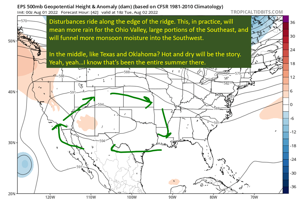
As of Saturday, 7/9, ridge that has been over the middle of the country has retreated west. Another ridge is located out in the Atlantic, and a bit of troughing is forming in between. That upper level troughing is going to end up hanging out over the Gulf Coast for most of the workweek.
What this means is rain chances are going to be high all week, and high temperatures might struggle to get above 90 by Tuesday and Wednesday due to all the clouds and rain. The bad news is it will be quite humid, which will support the rain but also mean the heat indexes will remain elevated despite the lower ambient temperatures. At least it will not be at levels that require a heat advisory.

Threat Of Flash Flooding Monday and Tuesday
We know the upper levels are going to be supportive of heavy rain, but there generally needs to be a focus at the surface to really reach the rainfall potential.
Yeah, you guessed it, there’s going to be a little bit of a front at the surface that will serve as a focus for showers and thunderstorms going into the early week. The main area of concern is going to be the Southshore, where the WPC has a slight risk of excessive rainfall on Monday.

So we have two of the main ingredients for heavy rain. An upper level disturbance providing lift and some cooler air aloft, increasing the instability. Then there will be a front near the coastline by Monday that will serve as an additional focus for storms to form. This pattern isn’t going to be quick to move either, so expect the heavy rain potential to extend far past Monday.
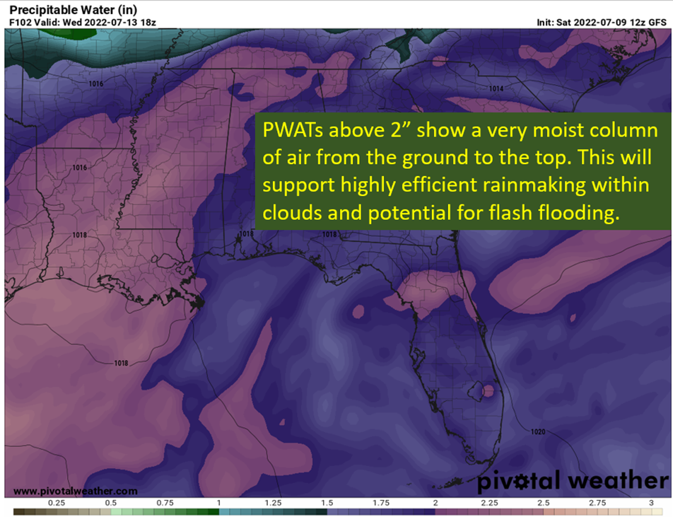
How Much Moisture? Well…It’s The Gulf Coast In July

You might have noticed the humidity. Low temperatures struggling to get into the mid 70s, which really puts pressure on vulnerable communities. It also brings the potential for exceptionally heavy rainfall, as this humidity extends up into the column. Plus, it’s summer and warm high into the troposphere. All together, this is how you get “efficient” warm rainfall making. You’ll be seeing those big drops and a whole lot of them in the deeper thunderstorms. This will create localized flash flooding potential each day this week across large portions of the Southeast.
Now to the complication…homebrew tropical action.
Storm Enough Over Hot Water And You’ll Make A Tropical System

I know, I know. It’s in communist units. All you need to know is 30+ degree water is what tropical cyclones dream about at night. So what is happening is there is a surface boundary, as mentioned above, sitting just along the Gulf Coast. This boundary has lead to persistent storms and a surface trough has began to form. If this trough was about 100 miles to the south, I’d be a lot more bullish on tropical development and potentially something stronger than a minimal tropical storm.

There isn’t much shear around, which you can tell from the slow storm movements from thunderstorms so far this week. The water is getting near “jet fuel” levels energy to contribute. The real issue is proximity to land. The WPC has a loose low pressure just east of New Orleans, but this is more like a tropical wave than something as closed off an organized as even a tropical depression. This rough low pressure center is just going to hang out over the northern Gulf Coast bringing rainfall.
If it does spend a lot of time over the open water though, you could see this develop into a depression or a weak tropical storm. Land interaction, again, is going to be what limits this plus overall lack of organization meaning it will take time even if over water.

tl;dr version
Yes, there is some tropical potential but the ceiling is very low if anything is going to develop. The reality is, the impacts across the Gulf Coast are going to be the same if it gets a tropical designation or not. Heavy rainfall is going to happen either way, with storms being extremely efficient rainmakers that can quickly lead to flash flooding. Those areas along the coast that get surge and flooding from even weak tropical systems will likely see some with this as well, closed tropical low or open trough.
This will keep the daytime temps down, but due to the humidity it will remain very warm overnight. Check on those who don’t have proper A/C, the elderly, and remember the homeless during this time.
That’s all for today, stay dry my friends.
Related Posts
Tropical Storm Ian Churns in Caribbean As Models Shift West
It’s Officially TD9, And The Models Are Targeting Florida
98-L: The Model Madness Continues
Getting To Know The Steering Players For Future Hermine
Danielle and Earl First Storms In Atlantic In Two Months
Still Watching Caribbean For Tropical Development
Watching The Caribbean For Tropical Trouble

The Tropics Appear Quiet For Next Couple of Weeks
A Brief Cooldown In The Southeast And Watching The Tropics