A Brief Cooldown In The Southeast And Watching The Tropics
Looking into the future the models are presenting, I’m expecting this to turn into a tropical blog by that last week in August. There is increasing confidence in the timing of sub-seasonal factors to switch the basin on around that time. Now, there will probably be a storm or two before the end of August but I expect those to mostly struggle and be of little consequence. There is still a lot of dry air hanging around the main development region (MDR) and the next week to ten days looks awful sheary.
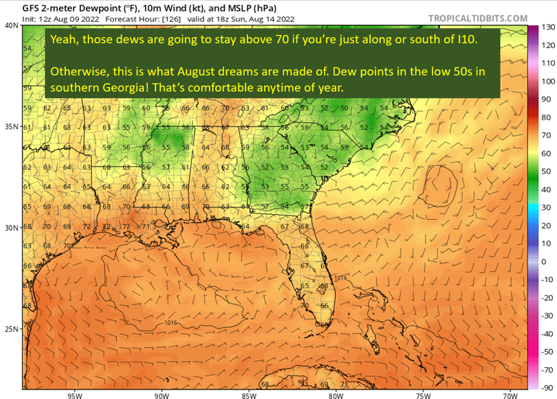
Before we get to the favorable period in the tropics, much of the southeast is going to get unusually pleasant weather by the weekend. The farther south regions, like the Gulf Coast, likely won’t get much relief but will see rain and clouds to keep the temperatures reasonable or even below average. Farther north and east, looking at you Northern Georgia, it is going to be downright pleasant this weekend. Flow from the north will bring unseasonably dry air with the base of an unusually deep trough overhead. That trough tells us the airmass is going to be very cool for this time of the year.
The Rundown
Today’s post actually is going to have a good logic to it. I’m going to start with the trough bringing more unsettled but cooler weather to the Southeast. Then I’m going to turn to what that trough is doing for the future of a wave already over the open Atlantic, and guys, it’s good news. Then we stay in the tropics but start looking out to the future for the players that will get this hurricane season going (most likely).
Ridge To The West, Trough To The East. Beautiful Northerly Flow For The Southeast

This is a pretty damn interesting pattern to see in August. It means nothing, big picture, just an interesting set up for the time of year. What it does it uncork some dry air from the High Plains and push it to the south. This will bring relief from the humidity to most, but the relief won’t be much for those near I10.
I will also point out, the cooldown is going to be true for eastern portions of SEC country. North Alabama, through Georgia and South Carolina should see unseasonably cool temperatures. Farther to the west, toward the Lower Mississippi Valley, temperatures aren’t going to drop all that much. Expect the diet of 90s – 100s to continue for Louisiana, Arkansas, and Texas.
In addition, this northerly flow is going to change the storm character of the afternoon storms this week and into next. We will see a transition from the prolific rainmakers to storms with less biblical rainfall but significantly more wind and some small hail potential. This is due to pushing in drier air aloft, which causes evaporation of rising air and falling motion on top of gravity pulling it down. This is what we call “Downdraft CAPE” or DCAPE.
In summary: Georgia gets an amazing weather weekend in August. It stays hot in Texas, Louisiana, and Arkansas. Those afternoon storms will tend to be less of a flash flood threat and more of a wind/lightning threat due to the flow from the north bringing in drier air aloft.

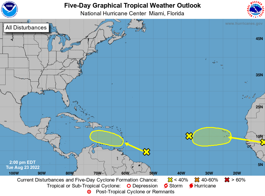
Wall of Shear Ahead For Future (maybe) Danielle

That wave is already a dead man walking. It will have a chance to develop into a depression or maybe get to be Danielle by Thursday, but after that conditions become increasingly hostile. This wave will eventually get fed into the eastern edge of the trough over the Eastern United States I discussed above. The shear from the trough will certainly open up a barely organized system and send it to an early (thankful) demise. Even before then, once this wave gets to about the Lesser Antilles, shear will become a significant hinderance to development.

Don’t Let The Current Lull Fool You, The Tropics Are Going To Wake Up
This next bit is going to have me just “yada yada” over some technical stuff. I don’t think it’s necessary for you to understand the details of what is going on to understand what the end result will be. I would be willing to write up a technical explainer at some point, if there is interest.

Two important features, the Madden Julian Oscillation (MJO) and a Convectively Coupled Kelvin Wave (CCKW) will be passing through the tropical Atlantic this week and into the next. As it continues eastward over Africa, there will be an increase in tropical wave activity. In addition, shear will drop over the Atlantic following the passage of these waves. There are still lingering questions as to how much dry air will hang over the main development region (MDR).
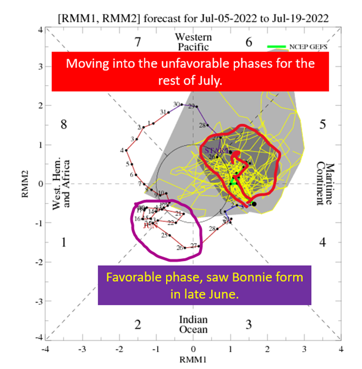
The result of all of this will be a more favorable background for tropical cyclones just as the time when we normally see the most tropical systems. Looking at European weeklies as well as the chart above, the window for an increase in tropical activity will open about August 20th. It generally takes a little bit of time from the window opening to stuff happening, so I’d think that last week of August is when things really kick off.
I’m going to be watching the models, just to see if they pick up on increasing action and specifically when they want to do it. It won’t necessarily be something that ends up forming, but an increase in phantom storms on the models tells you conditions are improving.
At that point, we can start to look at how the steering would set up.
tl;dr version
Humidity relief is coming for all but those right along and south of I10 this weekend as northerly flow dominates the Southeast. This won’t bring heat relief, at least to SEC West country, but certainly will bring lower temps to Georgia and South Carolina. Dew points should be downright pleasant for large swaths of the southeast, making for a nice weekend even if you’re sitting the mid 90s out in North Louisiana.
One notable change with this regime will be the storm character, with afternoon storms having more wind and lightning vs being prolific rainmakers. Don’t be surprised to see a few catch severe warnings with drier air aloft being pushed into the Southeast.
There is also a tropical wave in the Atlantic with a 20% chance of development by the NHC. If it does develop, it will remain a tropical depression or just hit minimal tropical storm status before shear destroys it when it reaches the islands.
Looking farther ahead, the window for increased Atlantic hurricane activity should open up about August 20th. I think it is likely to take a few days before anything actually kicks off, putting the last week of August as my target for tropical action.
Related Posts
Tropical Storm Ian Churns in Caribbean As Models Shift West
It’s Officially TD9, And The Models Are Targeting Florida
98-L: The Model Madness Continues
Getting To Know The Steering Players For Future Hermine
Danielle and Earl First Storms In Atlantic In Two Months
Still Watching Caribbean For Tropical Development
Watching The Caribbean For Tropical Trouble

The Tropics Appear Quiet For Next Couple of Weeks
Pattern Change Is Here: Rain Plus Some Tropical Homebrew Potential