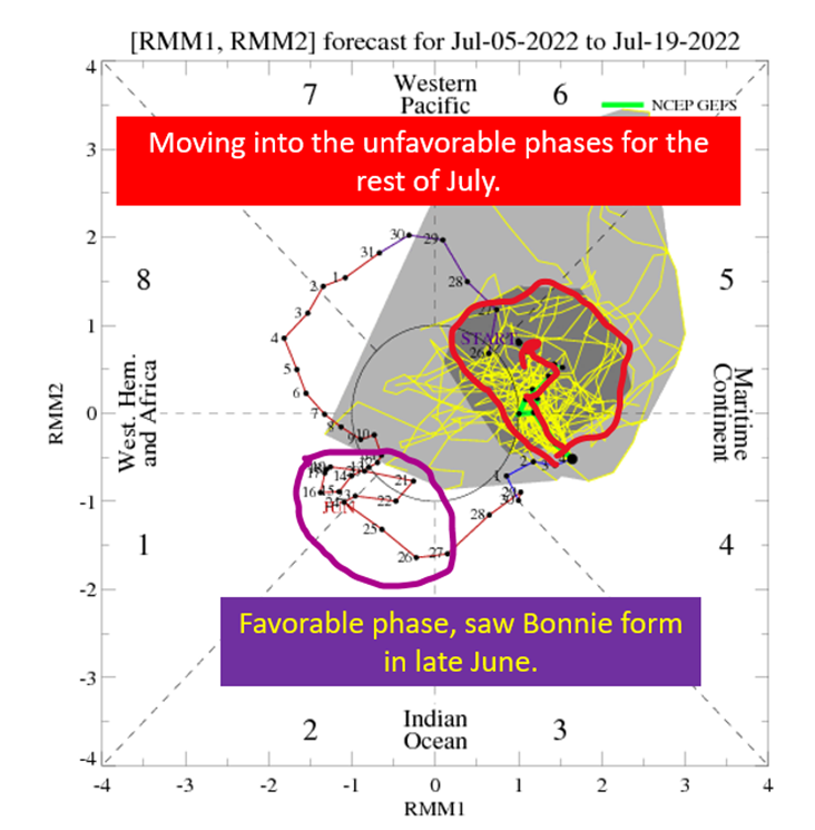
The Tropics Appear Quiet For Next Couple of Weeks

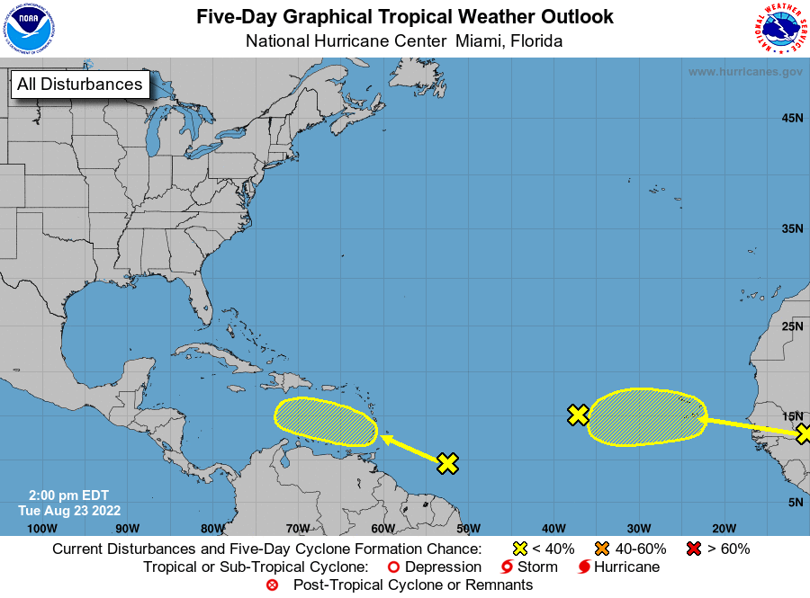
I’d expect to see more model activity at this point, in terms of tropical systems. The models, especially our good friend the GFS, will tend to spin up more storms than will actually end up happening. When it does get these “phantom” storms going, it lets you know the environment is getting favorable. Yet, there’s nothing on the models going into late August. Even the ensembles aren’t biting on much. The EPS on 8/16 at 00z only had two members get below 1000 mb through 8/26, and nothing get out of the MDR to threaten land.
In other words, there isn’t a lot to suggest we’ll see another tropical system and especially out in the open Atlantic, through the end of August.
Today, I’m going to show you how little activity the models are showing and look at the reasons why that is the case.
Ensembles Remain Anemic Into Late August

This is not what I was expecting to see off the GEFS at this point in the season. There’s not a whole heck of a lot going on here. It picks up on a wave coming off Africa and around a quarter of members develop it at all, and none above tropical storm strength. The image at the top of the post shows what the European ensembles are(n’t) doing, with an even more benign look across the Atlantic. I’m starting to think it won’t be until Labor Day that things really get going, assuming things ever really get going at all.
Looking at the climate (weeks to months range vs days to a couple of weeks of weather models) models, there is a tendency to keep the MDR somewhat dry in September. How wet/dry the tropics are in September are a good proxy for expecting above/below average tropical activity.
All in all, despite the La Nina again this year, 2022 is looking to be an average hurricane season vs the hyperactive 2020 and 2021.

Upper Levels Bringing Dry Air Aloft and Shear
When tropical systems struggle to get going, you can usually tie it back to shear and dry air. This case, at least through late August, will be the same as a trough over the subtropical Atlantic keeps dry air flowing into the MDR and shear present. This is despite the passage of a CCKW and a favorable MJO phase, which I was expecting to take the sting out of the dry air and shear. This could abate by September and send some long running tropical systems across the Atlantic.
If it doesn’t, we will still have to watch the waves that don’t develop as they might find a better pocket of conditions closer to land. This has been the story the past two years along the Gulf Coast, with waves not getting organized until the Western Caribbean where they have no where to go but land. So while we love to see dry air and shear keep storms from forming, do keep in the back of your mind the potential for late bloomers to spin up.

Don’t Sleep On The Homebrews
There is one wave out there, sitting of the coast of Nicaragua, that will drift into the southern Gulf of Mexico over the next few days. It has a chance to develop into a minimal tropical storm, but I want to point out this benign case to highlight the potential to have a storm form close to home. If the steering and upper levels would to play nice, a little disturbance could turn into a big problem in the matter of 2-3 days as hot as the Gulf of Mexico is.
This system won’t have the luxury of time or totally benign conditions but will still have enough time storming over water to possibly become our fourth tropical system of the year by the weekend.

With the Tropical Atlantic looking dead for the next week or two, I’m just more concerned with systems that could spin up closer to home with the warmth in the Western Caribbean and Gulf of Mexico.
tl;dr version
Look, I still expect to get a decent amount of tropical activity this year but every week we can go without it is very helpful for the Gulf Coast. The question, of course, is when does the activity turn on? Last week I was looking at the last week in August and I guess I’m still sticking with that idea. I’m just dialing back the confidence level. I expected the models to start backing off the shear and start developing some systems. This afternoon’s GFS kind of had what I was expected, with numerous closed lows. The thing is, the upper levels still weren’t ready to play nice on the GFS.
At this point, I’m looking for the shear forecasts to start dropping off. At that point, the dry air problem will likely be remedied by a few sacrificial waves to moisten the environment. Really the latter is going to happen anyway to an extent, but the dry air will continue to be pushed in from elsewhere until the upper trough causing the shear moves out of the way.
Still in wait mode y’all.
Related Posts
Tropical Storm Ian Churns in Caribbean As Models Shift West
It’s Officially TD9, And The Models Are Targeting Florida
98-L: The Model Madness Continues
Getting To Know The Steering Players For Future Hermine
Danielle and Earl First Storms In Atlantic In Two Months
Still Watching Caribbean For Tropical Development
Watching The Caribbean For Tropical Trouble
A Brief Cooldown In The Southeast And Watching The Tropics
Pattern Change Is Here: Rain Plus Some Tropical Homebrew Potential