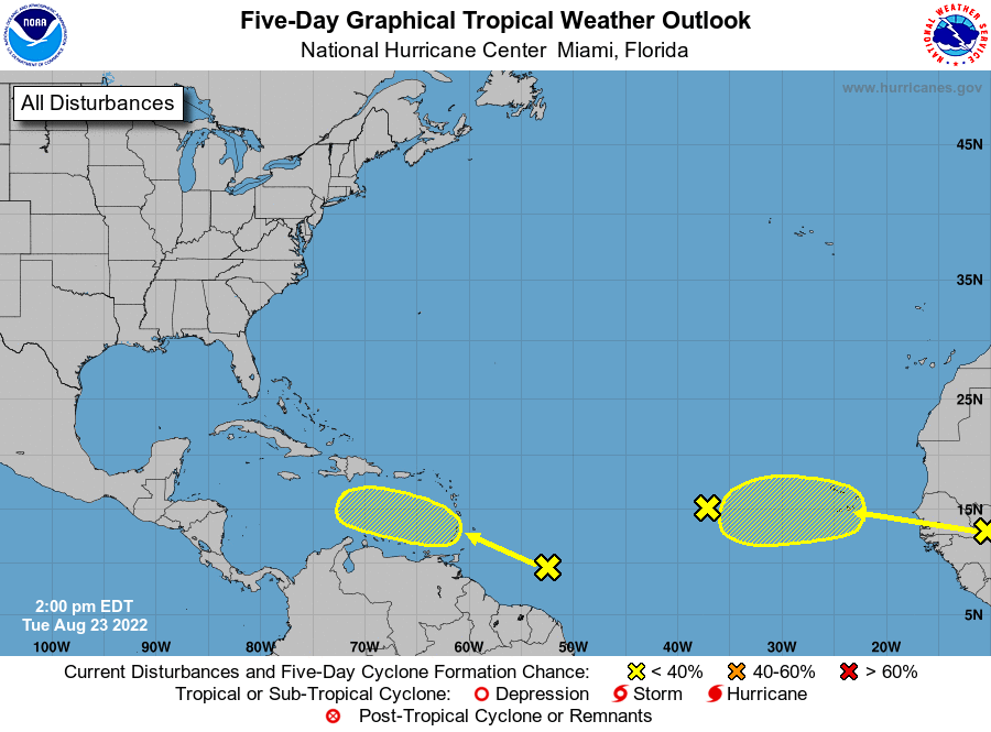
Still Watching Caribbean For Tropical Development
The Eastern Caribbean wave is yet to develop, which means we shift our area of focus to the Western Caribbean early next week. The reason is, without good organized convection, the disturbance couldn’t keep out shear from an upper low to the north of the system. So it will have to get farther west before having a window to develop.
Model support has been, ahem, anemic at best. Well, except the GFS, which is doing some strange but interesting things to spin this up in the Western Caribbean. So today, let’s look at the development scenarios and what the steering would look like if this does manage to spin up into Danielle.
To get started, let’s take a look at this disturbance.
There Ain’t Much To It

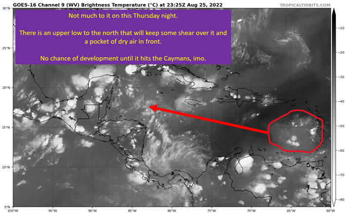
It’s nowhere close to being a tropical cyclone this evening. Looking ahead of it, conditions aren’t favorable for it to start developing until near Jamaica and the Cayman Islands. There is a pocket of dry air in front of it (see the dark colors) and there’s an upper low to the north that will put shear on the system. As you can see, the airmass in the Western Caribbean is moist and by this point the upper levels should be somewhat helpful for development.
All that said, signs point to a sloppy development (if any happens) as there probably won’t be all that much to it once it reaches better conditions.
GFS Version Of Genesis Remains Suspect
00z on 8/26 follows the Happy Hour (18z) on 8/25, with an interesting genesis for a potential storm. This “wave” ends up being shoved due west into Central America. Behind it will have wind out of the S and SW. This creates a bunch of convergence at the surface in the Western Caribbean. You get a focus for convection and the upper levels are supportive.
The GFS ends up having this new northern focus and the original wave spin together into a large circulation. It quickly consolidates the broad rotation into a strengthening tropical cyclone.

This is an area of the basin where the GFS spins up quite a few false alarms. Ensemble support has been anemic too, until 12z on 8/26 and just from the GFS suite.
At this point, I think the GFS ends up wrong and this doesn’t form. That, of course, doesn’t mean we stop watching the Western Caribbean. With any model showing something this time of year, you watch it. Especially when conditions are full steam ahead if something does form.
On The Off Chance This Develops, It Will End Up In The Gulf Of Mexico

The problem with just assuming the GFS is wrong, is that on the off chance it’s right, conditions would support a major hurricane in the Gulf of Mexico. Again, this most likely doesn’t form, so no need to get worked up over this now. Just have awareness this has a small chance of being a big problem for someone along the Gulf Coast.
Not much more to say on that.
Upper Levels Would Be Conducive To Rapid Strengthening In Gulf
Once Again, It Would Need To Develop And Odds Are Currently LOW.

Yeah. I’m glad the odds currently are against formation, because this is a dangerous upper level set-up over the Gulf of Mexico. A large upper level anticyclone sets up over the storm, allowing for a powerful outflow channel to set up. This outflow means the storm is able to remove the mass it is picking up at the surface and keep the pressure dropping. It also implies light shear. This is why the GFS is so aggressive with the system, once it gets it in the Gulf.
The key is, there actually has to be something there for this to be a problem.
tl;dr version
We will need to keep a close eye on the Western Caribbean next week, as a weak tropical wave moves through the region. There is very little model support for storm formation, with the GFS and it’s ensembles the only things showing this developing. This is in a region the GFS produces numerous false alarms in, and the method of genesis is suspect to me. Odds are, the wave out in the open Atlantic will get the Danielle name.
The problem is, if the GFS is right and I’m wrong, this wave would evolve into a major hurricane in the Gulf of Mexico. So we watch, just in case the GFS sniffed this one out but not expecting that to be the case.
Related Posts
Tropical Storm Ian Churns in Caribbean As Models Shift West
It’s Officially TD9, And The Models Are Targeting Florida
98-L: The Model Madness Continues
Getting To Know The Steering Players For Future Hermine
Danielle and Earl First Storms In Atlantic In Two Months
Expecting Danielle By The Weekend. Otherwise, Shear and Dry Air Dominate.
Watching The Caribbean For Tropical Trouble

The Tropics Appear Quiet For Next Couple of Weeks
A Brief Cooldown In The Southeast And Watching The Tropics