Invest 98-L With High Chances of Development
After a summer of weekly updates, the tropics have decided this is going to be more of a semi-daily blog over the next two weeks.
The reason is the wave I mentioned in the post yesterday, now Invest 98-L officially, is now being given a 60% chance of formation in 48 hours and 80% chance in 5 days. In the short term, development should remain slow as shear from Hurricane Fiona’s outflow will slow organization. I think formation ends up in more in the 4 to 5 day window, given the shear. This puts it somewhere in the central Caribbean before it starts getting together.
The problem is when it gets together, it should happen rapidly.
For today though, I just want to look at the short term prospects and motion of 98-L. Specifically to see if we can start to eliminate some outliers on the ensembles.
Ensemble Spread Remains Wide

You can see a general idea forming from the members. At some point, practically all of them get turned North. Questions of how sharp the turn is and exactly where it happens aren’t quite foreseeable yet, again, just the basic idea here. The spread of possible results here span from the Bahamas to Central America. So you know, don’t get too hung up on exact paths at this point.
What I find curious from the GEFS is the members that get picked up to the north very early. With the struggles future Hermine will be facing in the short term, I don’t really think it would be deep enough to actually feel the pull north that is happening in the mid to upper levels there. That’s why I want to dig into the short game. I find it better to not dismiss outliers offhand and investigate if there’s something to it.

Organization Will Be Slow Due To The Shear From Fiona

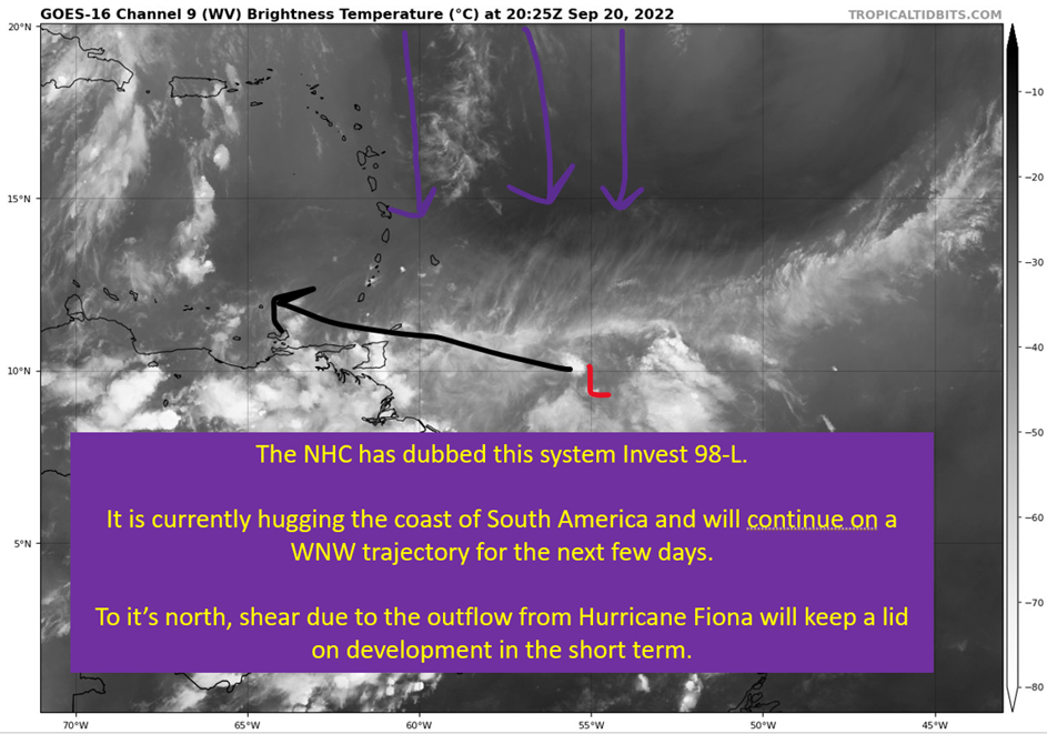
You see all the clouds flowing south around 60 to 55 W? That’s going to be putting shear over future Hermine. That northerly shear is going to keep formation slow, and that means uncertainty. Models perform better when there is an actual center to track from the start. That means short term uncertainty in exactly where this system will be in 3-4 days when the shear does start to drop.
What that ends up meaning long term? Probably not a lot. It not developing after would be the thing to throw a wrench in the works, though I’m skeptical of those solutions given how supportive the upper levels will be. Normally, looking at the GEFS, I’d expect those early turners simply be stronger earlier but that really isn’t the case. Which raises the question, is an early turn all that realistic?
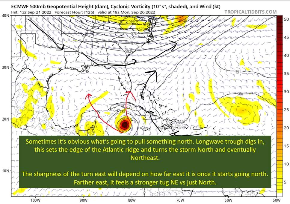
An Early North Turn Does Not Strike Me As Realistic

That trough is going to be the weather story of the weekend, as Hurricane Fiona undergoes explosive extratropical transition and impacts Maritime Canada potentially as a sub 930 mb low. Will produce prolonged and widespread 85+ mph winds across the region. While certainly a powerful mid-latitude system, it is just too far north to think it would grab a weak system like 98-L. The door that opens to let it north later is something different.
The deterministic GFS has been trending west with the system, at least through that early next week timeframe. I think that makes the most sense, with the system tracking toward the western part of Cuba. This really doesn’t change much in terms of the United States landfall location, which is still unknowable at this point.
tl;dr version
98-L is going to struggle to develop over the next three to four days as it fights shear from Hurricane Fiona’s outflow. In terms of potential Gulf Coast impacts, the short game doesn’t mean all that much. It does mean, in all likelyhood, the eastern outliers on the ensembles that have it missing the United States entirely aren’t going to be correct. What probably happens is it ends up farther SW than what the GFS currently is doing (and even the ensemble mean). It should still turn north eventually, as a powerful hurricane, and approach the western side of Cuba.
From there, it gets really uncertain, other than this has a good chance of being a major hurricane at landfall.
I’m going to not post tomorrow but on Thursday I intend to discuss in some detail why the strength potential is going to be so high on this one.