It’s Officially TD9, And The Models Are Targeting Florida
Getting started late today, got out to look at all the fall colors with my daughter this morning. Great way to spend our birthday together. Plus, I need to clear my mind of the tropics for a couple of hours on occasion.
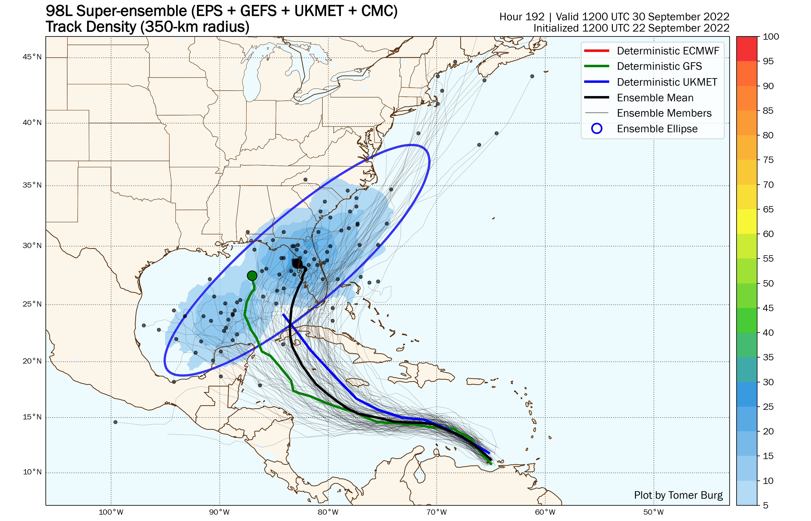
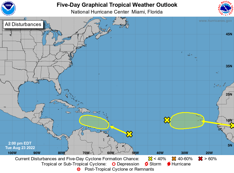
It’s time to get back to it, as TD9/Future Ian (yes, another storm is probably going to steal Hermine and ruin my past few posts) continues it’s slow development in the Eastern Caribbean. The big change has been the GFS, which came crashing toward the European/HWRF solution of Florida. While there is still an outside possibility of an Louisiana approach, everything is pointing to a West Coast of Florida landfall.
Today, I’m going to look a couple of small questions on track in the short term. Then, with an NHC track to work with now, I will look at the intensity potential on each major step of the storms journey. Spoilers, I’d start actively prepping for a major hurricane if I lived in Southwest Florida.
The Euro and an Upper Low. The GFS and the Downshear Convection.

That upper low, shown above in red, was causing the European a little bit of trouble yesterday. The reason is the European tends to be a little too weak with tropical systems. That means the model isn’t seeing the amount of outflow the storm would ACTUALLY be producing. Most likely, and this is what happens on the HWRF, there would be enough convection from TD9/future Ian to break down the upper low and not end up quite as far east the European has been. Though, at 12z today, it did come back toward the NHC path.

On the other hand, you have the GFS letting shear cause what looks like a center reformation to the west following convection. This is a process that happens, and will likely happen to some extent with this system. That said, the GFS overdoes it in situations like this and I fully believe it is currently doing so as well. What this leads to is a bit of a west bias, as it has the system picked up by the pull north farther to the south and west.
Keep these in mind, because I expect the solutions to converge more and more as these biases on each model are shown to be incorrect.
But I’ve also been wrong before.
TD 9 Is Currently A Sheared Mess, With Convection Mostly To West Side

Wait! But you said the GFS was wrong about the downshear convection and yet…there’s a whole bunch of downshear convection here.
To you, astute reader, I say the GFS isn’t necessarily wrong about the idea but I think it is to the extent it drags the center west.
The shear that we’ve been expecting is there! Look at the above gif closely, and you can see low level clouds rotating counterclockwise to the east of all the storms. Guess what y’all, that’s the naked center of this tropical depression. All the storms are being blasted from the NE due to the outflow from Fiona. This pattern has been sustained too, so it would not surprise to see the center get pulled west by all of that convection.
Just not quite to the extent the GFS has been showing.
I hope y’all enjoy the sheared look to this system, because conditions are going to improve dramatically for the storm by Sunday.
The Upper Levels Become Incredibly Helpful But Track Will Matter

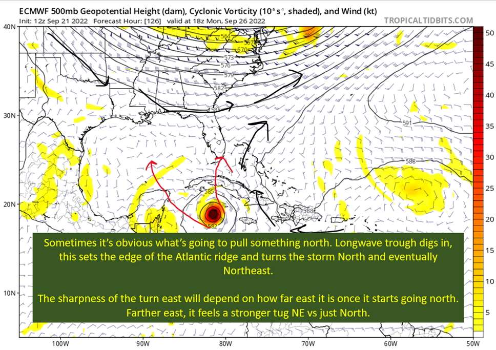
There’s no sense in sugarcoating it. The models are all presenting an explosive environment in the NW Caribbean. That is one of the hottest spots in the entire basin in terms of water temps and hot water depth. In addition, the storm should be placed relative to an upper level anticyclone.
What you need to know is this results in a low shar environment, and one that helps the storm remove mass (makes it stronger) from the center. This favorable set up should remain, assuming the storm takes the NHC track into a southern part of Florida. Now, if it gets far enough north (like the Panhandle), shear will be pretty high and likely cause a weakening right before landfall in that scenario.
One thing that might take the top off the intensity potential is the track over Cuba. Any trip over land disrupts the boundary layer, even if mostly flat. That generally means 12-24 hours are needed over water to get back to strengthening. Now, if the storm goes farther east, it gets higher terrain and more land to cross. This would cause a longer disruption of the circulation, and would position it to get pulled NE quick. Farther west, and the opposite is true.
This is just a reminder that the high end potential remains very high here, but that potential depends on the exact path.

tl;dr version
We officially have TD 9 now, and the initial forecast targets southwest Florida with landfall. Reasonably, it looks like the Big Bend to Key West is the zone at threat for a landfall. Of course, if it landfall on either edge of that range, there would be effects to the outside of the area I mentioned. Don’t just focus on the center line path.
Right now, the storm is sheared with convection all to the west. This could potentially pull the storm a little farther west in the short term than expected, but probably not as aggressively as the GFS has been doing for the past two days.
This storm will likely be a major hurricane at a United States landfall, and probably when it landfalls on Cuba. The upper levels are incredibly helpful to a hurricane, and the water is both very warm and deep. If I’m on the Florida Peninsula, I’m getting my hurricane prep rolling today. Along the northern Gulf Coast, just keep an eye on it but the trend is looking better for this region.
That’s all for today. We’re going to marvel at Fiona tomorrow, and just check in with the models and forecast for TD 9. Have a good one y’all.
Related Posts
Tropical Storm Ian Churns in Caribbean As Models Shift West
98-L: The Model Madness Continues
Getting To Know The Steering Players For Future Hermine
Invest 98-L With High Chances of Development
Danielle and Earl First Storms In Atlantic In Two Months
Still Watching Caribbean For Tropical Development
Watching The Caribbean For Tropical Trouble

The Tropics Appear Quiet For Next Couple of Weeks
A Brief Cooldown In The Southeast And Watching The Tropics