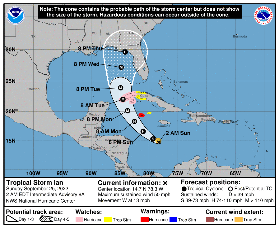
Tropical Storm Ian Churns in Caribbean As Models Shift West
The next 24 hours are going to be illuminating on the future of Ian.
Center will finally be consolidated. Upper air data will be fed into models tonight (not yet run as of me writing this part) and we will start having two additional weather balloon launches a day across the eastern United States NWS offices. All of this combined should have the models start to converge toward a solution.
The other thing to mention is Ian will probably make a run toward Category 5 status, but don’t fret too much. The storm is expected to weaken significantly on approach, and for good reason. There will be significant shear and dry air over the Northern Gulf Coast. This is the kind of shear that eventually destroys storm, not just a speed bump.
There will still be significant impacts from surge east of the center, from rainfall due to a slower system, and still some wind impacts as it is expected to still be a Category 1 at landfall.
The Models Shift Westward Today. On Back Of Downshear Convection
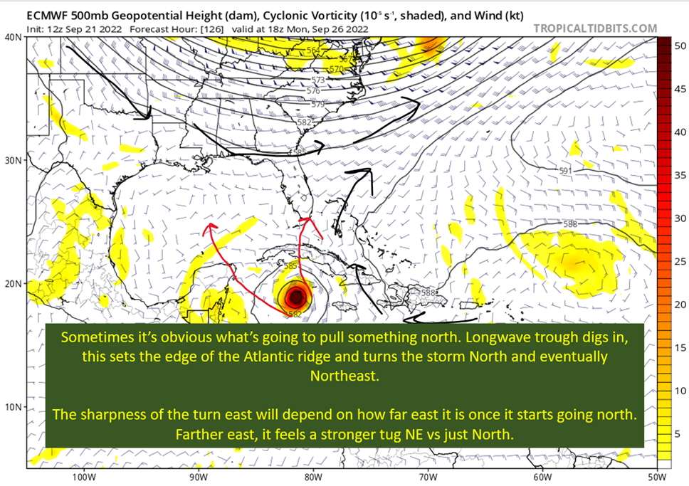
The far north solutions got eliminated over the past 24 hours, due to the shear causing convection to be offset to the west. This meant the models missing this dynamic were pushed into correction mode. I mentioned that was likely yesterday, but thought the GFS was overdoing it. It was overdoing it, but not to the extent I thought it was. That’s a large part of the push west.
The other is the upper low that had the European and others near Key West is being pushed away by the stable outflow from Ian. That doesn’t draw it north as quickly, and moved the Cuba target to the far west/missing entirely.
The GFS Scenario: Misses The Hard Turn Northeast. Slowly Moves Toward Panhandle of Florida

This scenario involves the storm being a little farther to the south initially and in the very short term. It feels the big eastern trough and moves north into the Yucatan Channel. At this point, it would be a very powerful hurricane and remain such into the Gulf of Mexico. The timing is such, in the GFS scenario, that the trough ends up too far east to fully capture Ian. So instead of a run at the western Florida Peninsula, it gets left behind in a regime of weaker steering. There would be enough to push Ian north, it would just slow down.
The other thing to realize is the storm weakens considerably upon approach to the Panhandle, as shear picks up by the end of the week. It would still be a Category 1 hurricane, and bring significant surge and rainfall. The wind would be enough to knock out power and knock down some trees but nothing like Michael, Laura, or Ida.
So don’t panic, assuming a Panhandle landfall is in the cards (which is far from certain, with the NHC currently farther east around the Big Bend), when there’s a borderline Category 4/5 in the Gulf.

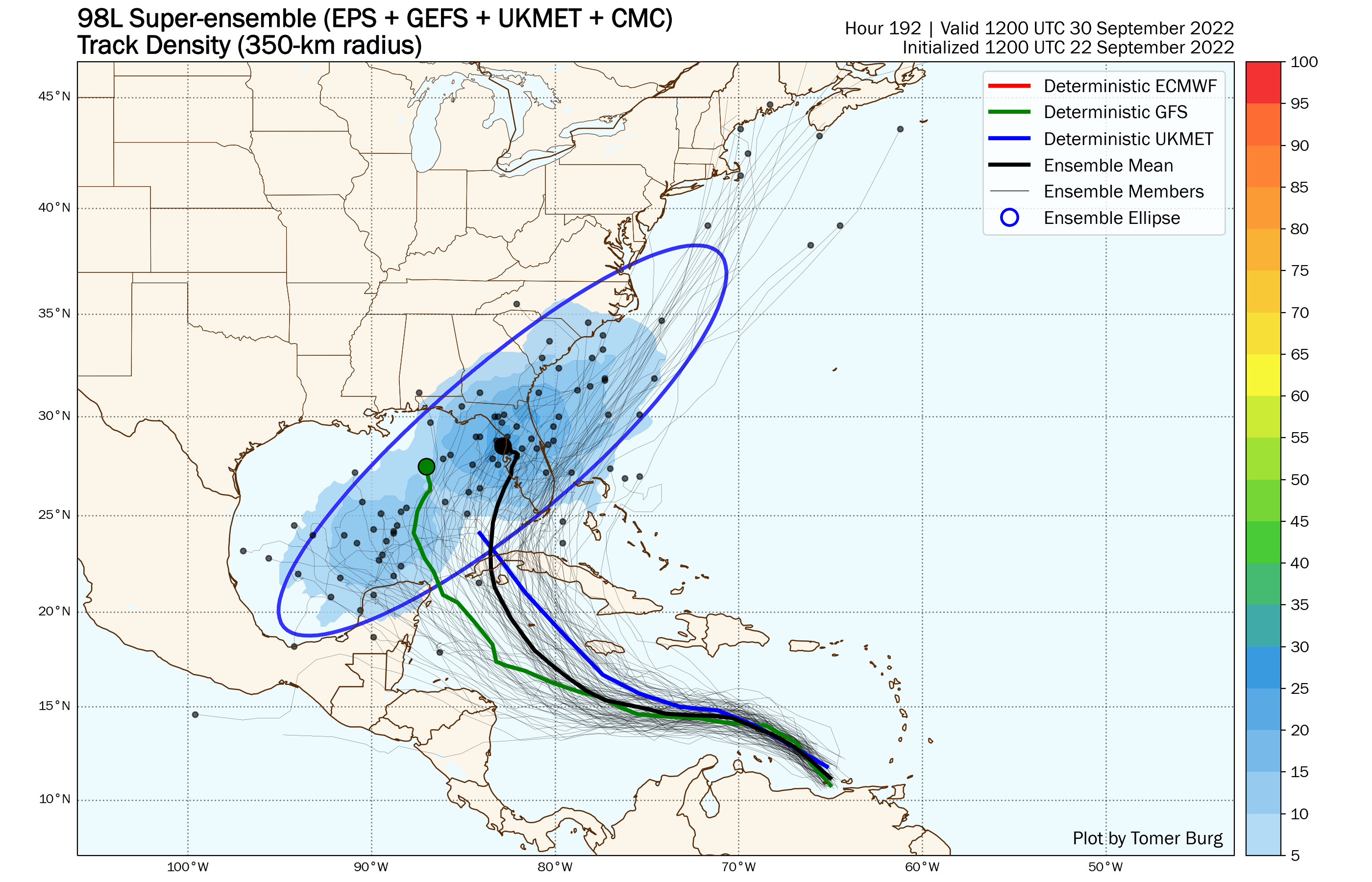
GFS Ensembles Between Tampa and Mobile

The spread is wider than that really, with a couple of members hitting the Yucatan. Looking at the vast majority, the GFS ensembles put the range roughly between Mobile and Tampa. It doesn’t appear the upper air mission provided all that much clarity. I also see a little bit of split camps, with those members that cross over more than the western tip of Cuba hitting the West Coast of Florida. Most of those that hit the Yucatan Channel or just the western tip of Cuba end up a Western Panhandle storm.
The European Scenario: Ian Catches NE Turn. High Impact Scenario For Western Florida

The European ends up just a little farther East and a little faster coming over Cuba. This allows for the trough to capture Ian and send it toward the western Florida Peninsula. The question I have about the European solution is how weak it remains in the Caribbean. A storm in the 980s is just unrealistic with how explosive the upper level set up will be. This could allow a weak upper low to nudge it north more in the Caribbean and then be in position to get fully captured by the trough.
If this scenario is correct, it would be a dangerous situation because the storm would not weaken much going into landfall and would be stronger than the Euro’s 960 mb storm at landfall. The farther east and faster the landfall, unless it is Key West far to the “east”, the stronger the storm is likely to be at landfall.
The thing is, there isn’t a huge difference between the two models. Timing and exact position are going to be the difference between a very serious situation for the West Coast of Florida and a dangerous but manageable one for the Panhandle.
tl;dr version
Significant differences in the models remain. There are two main scenarios of interest:
- GFS Scenario: Misses Trough. Goes into Panhandle Friday while rapidly weakening.
- Euro Scenario: Catches Trough. Goes into West Coast of Florida or Big Bend as a strong hurricane.
We’re not a whole lot closer to answering which version of events is correct. This doesn’t consider outlier but reasonable cases as far east as cutting over far southern Florida or coming as far west as Mobile/Mississippi Coast. Anywhere east of New Orleans should keep an eye on this, and check in with your local NWS office. Also those NHC updates every six hours are critical.
One thing we do know, or at least I’m very sure or, is Ian will be a powerful hurricane at some point in the next few days. If it ends up going to the Panhandle, the good news is it will rapidly weaken on approach. Even over to the Big Bend it should weaken. The problem is if it ends up south of there, as Ian would likely remain a major hurricane.
The models should come into better agreement today as we get a well defined center.
Related Posts
It’s Officially TD9, And The Models Are Targeting Florida
98-L: The Model Madness Continues
Getting To Know The Steering Players For Future Hermine
Danielle and Earl First Storms In Atlantic In Two Months
Still Watching Caribbean For Tropical Development
Watching The Caribbean For Tropical Trouble

The Tropics Appear Quiet For Next Couple of Weeks
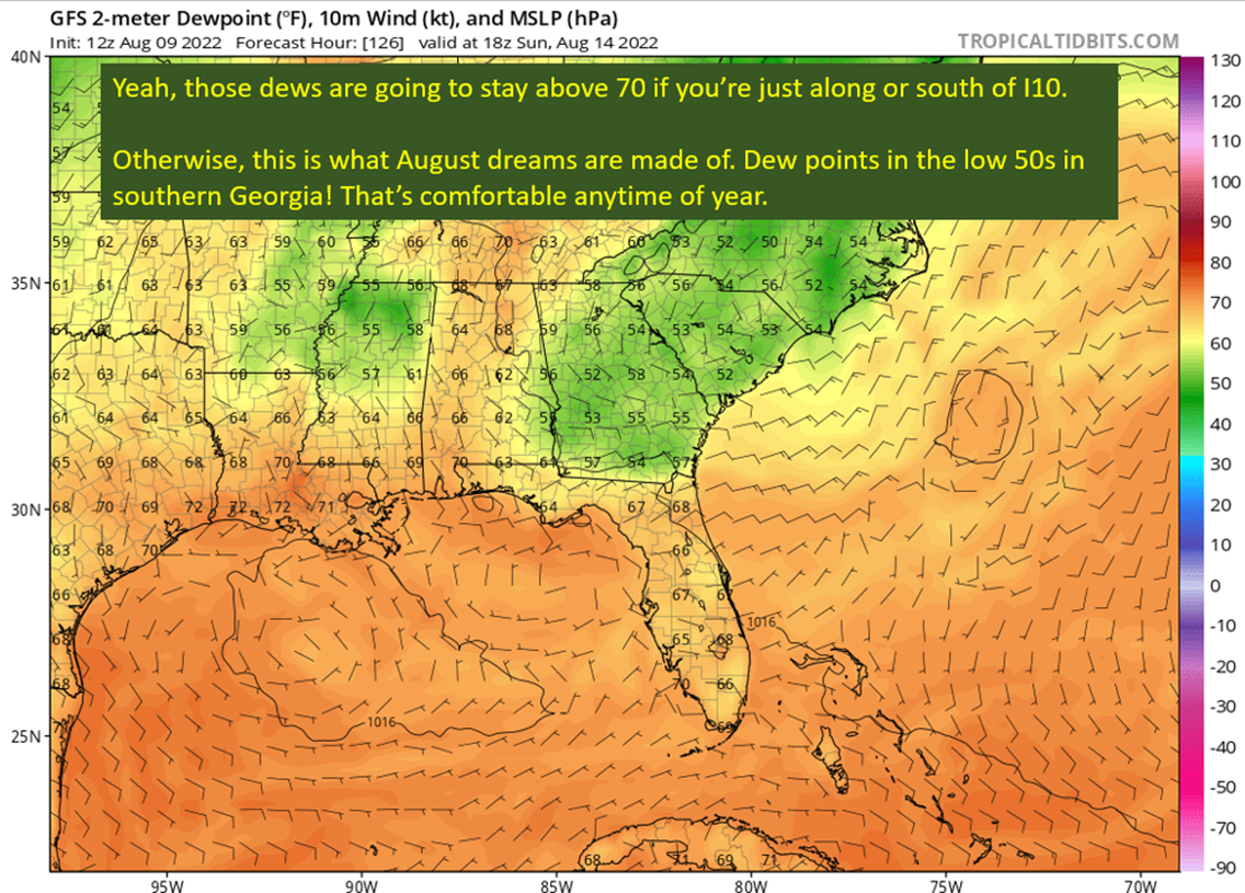
A Brief Cooldown In The Southeast And Watching The Tropics
Pattern Change Is Here: Rain Plus Some Tropical Homebrew Potential