NHC Forecasting Near Nightmare Scenario For Tampa
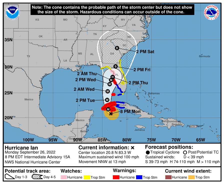
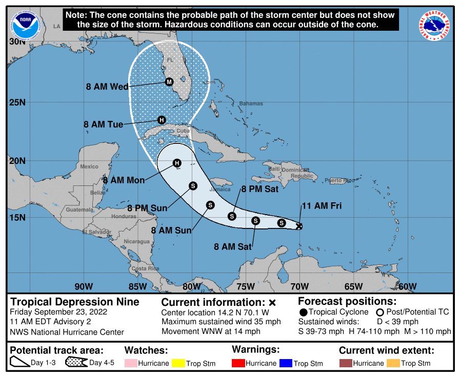
If the NHC centerline forecast, Advisory 15, is correct for Ian then Tampa is staring down a catastrophic flooding event. It’s been my biggest concern as the forecast developed, something comes in directly at or just north of Tampa. It would push surge directly into the Bay, the Bay that Tampa has their storm runoff drain into. A storm with a path like this has been as much feared in the weather community as “The Big One” into New Orleans.
For those in the path, I’ve got some resources for you. At this point, you need to consult the NHC and your local NWS for the best information for your area. I don’t know Tampa all that well, or any of the surrounding area. I won’t be able to give clarity on your flood risk or your own personal risk. I can only give additional context to the forecast.
Some (Hopefully) Helpful Links:
National Hurricane Center – Full updates at 5/11 am and pm Eastern Daylight Time.
NWS Tampa – Your local NWS Office. Just a bunch of cloud nerds working 18 hour shifts to keep you informed.
Weather Offices For Where You May Evacuate To:
Twitter Links:
The Intensification Is Happening, Though Not As Rapidly As I Expected

I thought Ian was going to explode overnight, but instead just did a healthy round of intensification. The culprit is seen on the SW core of the system. Something was interfering with the convection on that side and reduced the winds. This meant Ian wasn’t picking up water vapor as efficiently as possible, and slowed the process. Still, it was enough to get us to 100 mph at the 5 pm eastern update today. Looking at recent microwave passes, this doesn’t appear to currently be a problem and thus I expect Ian to explode in strength tonight.
There are going to be two planes in there very soon, so I won’t have to wait long to know the truth of the matter.

The Models Converged On The Tampa Area This Afternoon, But Ensemble Spread Remains

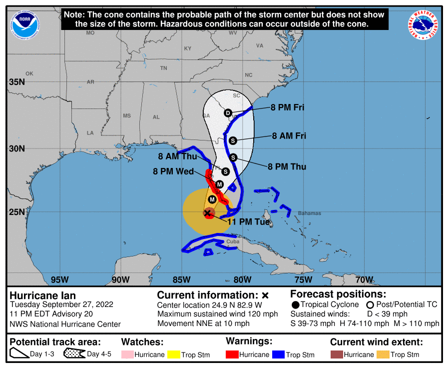
All the deterministic models keyed on Tampa this afternoon, which is a bad sign when within three days of a landfall. It is important to see there are still quite a few ensemble members that manage to save the Tampa area the feared strike. This is a very difficult situation for a forecaster, with a storm running practically parallel the peninsula. If the center is just 30 – 50 miles west of expectation, the worse fears for Tampa will be avoided. We’ll hear about how things always bust for Tampa…yada yada yada.
Do realize the base case is for a major hurricane to landfall or at least brush the Tampa area and deliver 5 – 10′ or more of surge into Tampa Bay. Anyone in the area needs to prepare like that is going to happen in three days. Period!
I just want y’all to be aware the is some uncertainty remaining in the forecast.
Surge Plus Excessive Rainfall Present Catastrophic Flooding Potential For Tampa

Catastrophic surge for one of, if not the most, storm surge vulnerable city in the country. Don’t trifle with evacuation orders. Water kills more people than anything else in a hurricane. Life threatening flooding is likely throughout the Tampa region.
To make matters worse, Ian is expected to slow to a crawl on approach. This would potentially put 6-12″ of rain across the region, all to drain into a surge swollen Tampa Bay. Even if you’re not all that close to the Bay, all of the waterways that drain your storm water are going to back up. Leaving no where for the excessive rainfall to go but rise. The NHC Forecast would be nothing short of a flooding catastrophe for the Tampa region.
I hope those western members are right from the ensembles. They could be, assuming the rapid strengthening happens. There is some SE flow in the upper levels that could nudge this west enough to prevent the horrible scenario I explained above.
You cannot bank on that if you’re in Tampa. Prepare like the worst is coming, and hope the best happens.

Ian Should Reach Major Hurricane Status By Morning

Ian didn’t intensify as fast as I expected last night. It appears to have ingested some dry air this morning and did some core reorganization. Recon in the system right now shows a pressure of 962 mb, with pressure dropping some 20 mb this afternoon. This should continue until the system slams into Western Cuba. A run up to a Cat 4 overnight doesn’t seem crazy, since the winds still need to catch up to the pressure drop and it’s already at 100 mph.
After that, it will take a little bit of time to get going again. Even if the circulation isn’t all that disrupted, the boundary layer will be all messed up. It’ll need at least twelve hours to get that moisten back up and start to intensify again once it enters the Southern Gulf.
tl;dr version

While it is not set in stone, all guidance and the NHC is pointing toward a devastating impact for the Greater Tampa Region. If the scenario of a direct hit or close swipe happen, flooding from surge across the region will be incredible. Listen to those evacuation orders very seriously. Now is the time to act.
Hopefully you’ll just be out a few days of time and a hotel room. I’ve had my home flooded before. It took a year to get back into my home and an immense amount of time, effort, and money to do it that quickly. I hope none of you have to go through that experience.
Pay attention to your local NWS Office and follow the NHC for the best forecasts and information for your area. I hope tomorrow will deliver better news, but there are fewer and fewer scenarios on the table that won’t have a significant impact.


One thought on “NHC Forecasting Near Nightmare Scenario For Tampa”
Comments are closed.