
End of March Severe Threat: 3/30 Deep South
Another week, another severe weather threat incoming. The Storm Prediction Center already has a 30% up across the I20 corridor with Northeast Louisiana, most of Mississippi, and western Alabama in this highest risk window. Further south, we have a 15% risk for the rest of Louisiana and along the Gulf Coast.
The main concern is going to be the tornado potential, with an outbreak possible in the 30% risk area. The more widespread threat will be damaging winds from bowing segments in the strong line of storms that will develop ahead of the cold front, thanks to the strong wind fields from the surface all the way to the top of the troposphere.
There will also be strong winds, even outside of storms, as a tight pressure gradient will set up across the southeast.
Alright, let’s jump into the details.

SPC Day 4 Severe Weather Outlook. The 30% is the area of greatest concern for tornadoes and damaging winds.
Surface and Low Level Winds:
They’ll be strong, with gusty winds ahead of any storms thanks to a strong pressure gradient between a high pressure off the Atlantic coast and a likely sub 990 mb low pressure moving into Iowa. A surface trough of lower pressure will extend south. Air moves from high pressure to low pressure, so with a big pressure differential like this, there will be a lot of air moving quickly toward the low pressure system. This will also serve to transport warm moist air out of the Gulf up into the Mississippi and Ohio Valleys. This transport will provide for some instability as well for the line of storms and potentially some supercells ahead of the line to use.

12z GFS depiction of surface winds from the 3/27/22 run. Image from pivotalweather, with annotations by Jacob Caddell.
Unsurprisingly, just above the surface a strong low-level jet is going to form with winds pushing 65-70 kts in an extensive jet core spreading from south to north. This core of strong low level winds will progress east through the day with our expected squall line and present potential for pre-frontal supercells ahead of the line. It also means there will be abundant low-level wind shear, as the speed differences between the ground and that 850 mb level will be significant which will help tilt and stretch updrafts. Basically, this is a piece you expect to be there in severe events.

GFS from 12z on 3/27/22, depicting the 850 mb (low-level) winds. Strong core of winds develops and will progress east over the day. Where this core is will have enhanced severe chances.
Mid and Upper Level Winds:
Spoiler alert, they’re going to be quite strong. As the main energy of the negatively tilted trough swings NE, 500 mb level winds will increase to 80+ kts out of the SSW with a core of 100+ kt winds hanging west of the low-level jet near the base of the trough. This push of winds will also increase the overall shear but also suggest to me there will be more of a line of storms threat vs a large number of discrete cells in the open warm sector. Of course, you can’t be content there won’t be any discrete cells but I do think a fast moving line of storms is more likely. This, as mentioned in previous posts, reduces the strong tornado risk but will increase the threat of experiencing damaging straight line winds. Especially with the strong shear and windfields available to get pulled to the surface.

12z GFS on 3/27/22 depicting 500 mb level winds, with image from pivotalweather. You can see the strong winds overlaying the Lower Mississippi Valley, with the core of the strongest winds just offset to the NW over Arkansas.
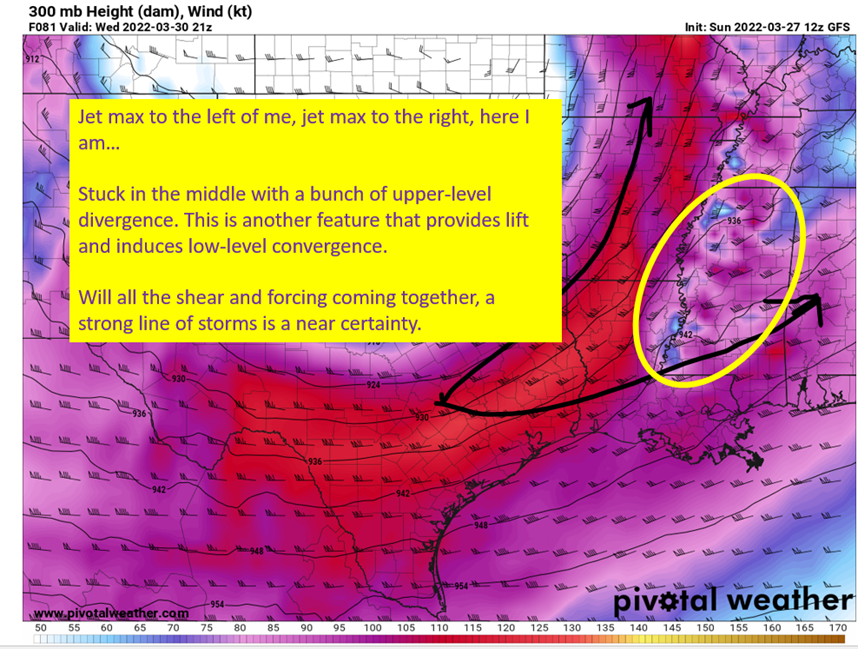
At the jet stream level, there will yet again be a split in the jet that leaves a pocket of strong upper divergence over Mississippi and stretching into Alabama. This provides additional lift and increases surface convergence.
The combination of good upper convergence, strong low level winds showing surface and low-level convergence, and the strong shear profile suggested by these strong winds all the way up the column should yield a more linear storm mode I think. The line will likely have imbedded tornadoes and damaging straight line winds. This does not mean there will not be discrete supercells ahead of the line, just that a linear mode looks the likely solution.

12z GFS on 3/27/22 depicting the 300 mb winds. Image from pivotalweather with annotations by Jacob Caddell. I circled the region of divergence, which is also the region that will have the greatest chance of seeing severe weather on Wednesday.
Instability
The instability at play looks somewhat modest, but is enough for severe storms with the very high shear profiles expected. There looks to be a small window of time where surface based instabilities will creep above 1000 J/kg over Mississippi and southern Louisiana but it does not appear to get much stronger than that at this time. Cloud cover and dew points on into the mid 60s on the southern extent limit somewhat the buoyancy that will be available. I want to see how the convective allowing models resolve the instability when they get into range early in the week, but I like the look right now.

12z GFS on 3/27/22 showing some surface based instability, but nothing all that impressive over the region. Image from pivotalweather.
Again, this is certainly enough with the forcing and shear to produce storms and tornadoes but does also limit the extent of those and the number of discrete cells I would expect in front of the line.
tl;dr version
A high shear/lowish CAPE scenario unfolds over the SE on Wednesday, with a threat of all modes of severe weather possible, especially in discrete cells in front of the line if they do develop. The line should provide plenty of severe threat on its own, with imbedded tornadoes and damaging winds the most likely impacts. Placement should be a little farther north of the event last week in terms of risk, with surface low tracking farther north and lower instability on the southern extent. This doesn’t rule out severe weather over the coastal regions! Just talking of where the most likely locations probably end up.
At this point, just be aware the threat will be there Wednesday and have a way to get warnings. Also, winds will be high on Wednesday even without storms overhead, so expect a warm and breezy day before the storms quickly move west to east across the region. That’s all for today, I’ll be back tomorrow as some of the convective allowing models come into range to see what they are doing with the system and to do a quick look at Texas and Oklahoma for Tuesday’s severe risk there.
Related Posts

Hurricane Season 2023 Preview: El Nino Returns

Gulf Low Will Bring Rain and Coastal Flooding

One For The Mardi Gras Skiers

Bust Out The Shorts For Mardi Gras

Hope You’ve Enjoyed Fall So Far. Looking Ahead At The Big Picture Into November.

The Media Coverage Of Ian Has Been Frustrating

Hurricane Ian To Make Second Landfall In Carolinas

Hurricane Ian Strengthens and Grows Larger With Landfall Tomorrow

NHC Forecasting Near Nightmare Scenario For Tampa
