
Here We Go Again: Severe Weather Middle of Next Week
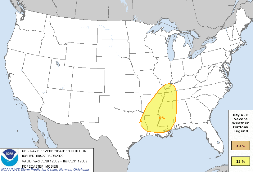
Through the weekend and into Monday an upper level trough is expected to migrate east out of California and into the Plains. By Wednesday it will swing NE through the Plains and Mississippi Valley while taking on a negative tilt. A strong surface low is expected to form ahead of it and draw warm moist air northward and present a severe weather threat across much of the southeast. The Storm Prediction Center has a 15% risk up for parts of Louisiana and most of the midsouth at Day 6, showing this should be another potent risk.
There are still a number of questions to answer though. The first is exactly where will have the greatest risk, as the current depictions from ensembles and operational models is to have the surface low farther north into Iowa as compared to this past event where it cut through Oklahoma and Missouri. That low track would likely shift the highest risk regions to the north vs our last event. Timing is also a question, with the idea being generally Wednesday but we do not know if we have a daytime or a nighttime threat yet.
At this point, I’m just trying to let y’all know of the potential. Today, I just want to look at the big picture of the ingredients to come together to start building situational awareness ahead of the event. It is too early to be concerned with details yet.

Above is GTA San Andreas explaining life in the deep south in late March and April.
Alright, so below I have an animation showing the GFS ensemble mean for the 500 mb vorticity (cyclonic spin that provides lift) and the geopotential heights going into next week. You will see the system come out of California and turn NE over the plains. You can also see the “negative” tilt happen, where if you draw a line from the base of the trough to the northern extent the line would be NW to SE. A negative tilt yields the most potential for severe weather, so when I see one, I pay attention!

GEFS at 12z on 3/25/22, showing the 500 mb heights and cyclonic vorticity. Gif made at tropicaltidbits using the forecast gif maker.
When there is this kind of forcing, there is going to be rising air and a low pressure at the surface in response. Once again, I want to take a look at the ensemble mean from the GEFS to show surface pressures. As you can see, the mean has a strong (990 mb is pstout for a storm system, and the operational models have it lower) low pressure that ends up in Iowa and moving in the direction of our upper trough.

The 12z GEFS on 3/25/22, showing surface pressure anomolies and the average position and strength of the low pressure of all the ensemble members. Image from tropicaltidbits.com
With a high pressure off the east coast, there’s a tightening pressure gradient that will certainly provide strong southerly and southwesterly flow across SEC country and even north into Indiana and Illinois. This will also serve to transport moisture northward ahead of the system. This means buoyancy being transported into the region, with strong midlevel winds. In other words, instability and shear. The stuff severe weather is made from. There are questions, of course, as to where the highest instability and shear will set up. Remember, broad strokes at this point.

This is the GEFS mean for precipitable water (moisture available) from 3/25/22 at 12z. Image taken from tropicaltidbits.com.
Finally, let’s take a look at the jet stream. Surprise, surprise we have a nice pocket of upper level divergence across the southeastern US and the Ohio Valley.

The 12z on 3/25/22 GEFS, showing the mean wind at 250 mb. Upper divergence also helps to create the severe weather risk.

The Storm Prediction Center has highlighted the Lower Mississippi River Valley as having severe potential Wednesday. In their discussion, they note the risk is likely to be increased in later updates if the model trends continue the way they are.
No need to get too worked up right now, just be aware this is coming and check in over the weekend and early next week to see how the threat has evolved. Otherwise, enjoy the beautiful weekend across the southeast! I’ll post an update sometime this weekend.
Related Posts

Hurricane Season 2023 Preview: El Nino Returns

Gulf Low Will Bring Rain and Coastal Flooding

One For The Mardi Gras Skiers

Bust Out The Shorts For Mardi Gras

Hope You’ve Enjoyed Fall So Far. Looking Ahead At The Big Picture Into November.

The Media Coverage Of Ian Has Been Frustrating

Hurricane Ian To Make Second Landfall In Carolinas

Hurricane Ian Strengthens and Grows Larger With Landfall Tomorrow

NHC Forecasting Near Nightmare Scenario For Tampa
