
Monday Severe and Previewing Tuesday
April is living up to its reputation with another multi-day severe weather threat. Tomorrow, we have a slight risk (2/5) running along I30 and up toward Memphis. It is not as apparent as the Tuesday and Wednesday threat, but certainly some hail potential in Dallas (shocking I know…) and a tornado threat into Arkansas. I’m going to do a top down of the Monday threat, and check some soundings to see about the details of the thermodynamics and shear.
Then will have a small discussion of the high potential but high bust potential on Tuesday in the plains and check in on the severe threat in SETX and western LA.
Let’s get started with the jet stream on Monday.

The 12z GFS on 4/10/22, showing 300 mb (jet stream approx) winds. Image from pivotalweather with annotations by Jacob Caddell.
This isn’t overly impressive, but does show a little divergence in the upper levels. Helpful for storms, but certainly not going to be enough to force widespread convection on its own.
The 500 mb chart is unimpressive with a broad pocket of stronger winds across much of the center of the country. The plains and AR/MO/TN end up in between a shortwave up near the Great Lakes and the large trough over the Rockies. Geopotential heights will be slowly rising across the region in question, which shows mid-level warming and supports a thermal inversion (cap) with height that will keep storms from forming until there is surface support from a boundary and end of the day warmth at the surface to overcome the cap.

The 12z GFS from 4/10/22, showing 500 mb wind and geopotential heights. Image from pivotalweather with annotations by Jacob Caddell.
Yeah, that isn’t a map I expect on a classic severe weather day. That’s part of why its got a slight risk (2/5) vs a higher risk level. Height rises and basically zonal flow just aren’t going to provide lift, which is why we will be watching for surface boundaries to initiate storms. These winds will help provide shear with differences in speed and direction below and above, so it will help support severe storms but will not be helpful in getting them to spark.
The low-level wind maxes are going to be displaced to the east of the main threat region too. There’s still enough low-level shear (20+ kt on many model soundings) to support tornadoes if storms get going but typically the low-level winds should maximize over the region of concern for higher chances of tornadic supercells.

The 12z GFS on 4/10/22, showing the 850 mb winds and geopotential heights. Image from pivotalweather with annotations by Jacob Caddell.
The story here is the upper levels can support supercells based on the shear that will be available but the height rises at 500 mb and misplacement of the low-level jet suggest a decent possibility no storms of note fire. The problem is, if they do they have potential for strong tornadoes, damaging winds, and hail.
Why am I worried about storms firing even though the upper levels aren’t especially supportive?
There’s going to be a cold front coming SE, which will cause some surface convergence (good for storms) and the undercutting cold air could overcome the limitations aloft.

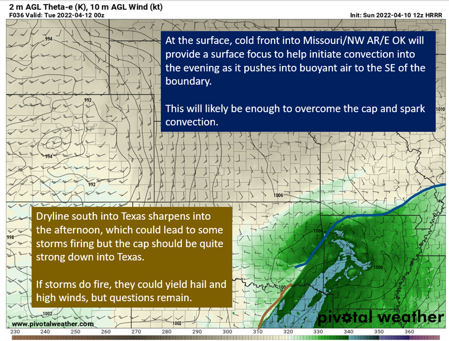
The HRRR from 12z on 4/10/22, showing theta-e (stand-in for warmth and moisture of the air) and winds at the surface. Image from pivotalweather with drawings and text by Jacob Caddell.
These (roughly drawn) boundaries will be what causes storms to fire. Farther south into Texas, it will be off a dry line but the cap down there is going to be strong. If storms happen, high winds and hail would be the main threat with some tornado potential. The better tornado potential is going to be in far NE Texas and into Arkansas ahead of the cold front. The shear profile in Arkansas going into tomorrow evening got my attention on forecast soundings. Critical angle near 90, a nice clockwise looping hodograph to match and one that shows winds increasing in strength with height. There is plenty of instability overall, though there is still a bit of a cap if you look at the equivalent temperatures on model soundings. In addition, lapse rates are steep which would support large hail.
Once again, questions on if storms are able to mature but if they do…look out. The sounding below tells of the potential in visual form.

A forecast sounding for SW Arkansas from the 12z HRRR on 4/10/22. Image from pivotalweather, with annotations by Jacob Caddell.
This is an impressive sounding profile. So if we get storms in Arkansas they have high end potential, especially if we see discrete cells.
The Plains On Tuesday:
I’ve talked about a threat down into SETX and SWLA yesterday, and will do another top-down breakdown tomorrow of that threat.
The big story on Tuesday though is going to be a high end threat across the eastern Plains. There’s going to be a cap, that if/when it breaks will put a high instability air-mass into a conducive shear environment. Large hail, violent tornadoes, and strong winds will be possible with any cells that can form. The greatest risk looks to be in eastern OK/KS, western Missouri, and into southern Iowa.
I will go into more detail on this tomorrow as well, with all of the convective allowing models in range to discuss but the last hour of the HRRR from 18z tonight is rather ominous.

A model sounding in eastern Kansas from the 18z HRRR on 4/10/22. Image from pivotalweather with annotations by Jacob Caddell.
This is for before storms would actually fire, but it tells of the danger ahead. Hopefully the cap just doesn’t break, but with geopotential heights falling ahead of a large upper low and the majority of models showing the cap breaking late in the afternoon on Tuesday I wouldn’t bet on it. Once again, going to dig into the details a bit more tomorrow for the Tuesday action. Just noteworthy potential. That’s why the SPC has an enhanced risk on the region already.
tl;dr version:
A conditional threat of severe weather will materialize over NE Texas and Arkansas tomorrow afternoon. The lack of upper level support means it will take help from an incoming cold front to potentially get storms going. If those storms can mature; however, they have the potential for tornadoes, large hail, and damaging winds. Some questions also remain on if the cells go fully discrete or cluster, assuming they do form. There remain differences in the convective allowing models if these storms even fire (the NAM doesn’t do much) but the HRRR does want to fire storms over Arkansas and presents a substantial risk to the Natural State if they do.
In other words, I’m not sure storms manage to mature or even fire in NE Texas/Arkansas tomorrow but if they do they will be dangerous. As always, have a way to get warnings in this region tomorrow evening.
On Tuesday, there will be two pockets of interest. One in SETX/SWLA and another into the eastern Plains. The southern threat is more low-key than the high end potential of the plains but I worry it is not getting as much attention. It will present a flash flooding risk, especially north of I10 and be supportive of all modes of severe weather. Then by evening, a high end threat will present its self over the eastern Plains. Now, it is possible storms don’t manage to fire or mature in the most dangerous regions but if they do the potential is substantial.
That’s all for tonight. Will be back tomorrow to dig into the details of Tuesday and preview Wednesday. April keeping the weather folks busy thus far.
Related Posts

Hurricane Season 2023 Preview: El Nino Returns

Gulf Low Will Bring Rain and Coastal Flooding

One For The Mardi Gras Skiers

Bust Out The Shorts For Mardi Gras

Hope You’ve Enjoyed Fall So Far. Looking Ahead At The Big Picture Into November.

The Media Coverage Of Ian Has Been Frustrating

Hurricane Ian To Make Second Landfall In Carolinas

Hurricane Ian Strengthens and Grows Larger With Landfall Tomorrow

NHC Forecasting Near Nightmare Scenario For Tampa
