
Tornado Risk For The Northern Gulf Coast
A tornado risk will increase overnight as storms move into Louisiana, Mississippi, and Alabama. The culprit will be increasing low level instability, though it isn’t all that impressive, but the low level shear could be enough to overcome and help mature updrafts in the low levels.
As mentioned yesterday, the more widespread risk is for large hail and strong winds within storms. The tornado threat is more conditional, but the potential is there for strong tornadoes overnight across southern Louisiana into Mississippi. Then by morning, the risk further increases over toward Mobile and the far western Panhandle as the instability will be more pronounced at the lower levels.
Before diving in too much to the future, let’s look at what is going on currently this afternoon.

Image made from the gif maker at tropicaltidbits. The upper low that is the spark for our system is progressing east out of the southern Rockies and into the Texas Panhandle and Oklahoma. It’s the counterclockwise swirl you see in that area. As it progresses, a surface low will ride just to the east of the swirl you see and start pulling moist air out of the Gulf of Mexico.

Surface analysis from 15z on 3/17/22 from the Weather Prediction Center. Here you can see the (old) position of the surface low cutting just south of Amarillo. Behind it are low dew points showing the formation of a dry line to come, and a cold front pushing out of the Rockies. In eastern Texas, you can see the winds are starting to come out of the south and this will transport warmth and moisture into the region this afternoon. This will provide the energy for the large hail threat near and NNW of Dallas/FW to start the “festivities” this afternoon.
Now to bust out the Microsoft paint.

My rough surface analysis to show the placement of the warm moist air and the dryline.

Image from pivotalweather. This is the HRRR run from 17z this afternoon, valid at 18z. This looks very similar to the surface observations from the SPC shown above this image, so the HRRR appears to have a good handle on the early game.
It is always useful to check and see how the models are doing with the initial conditions.
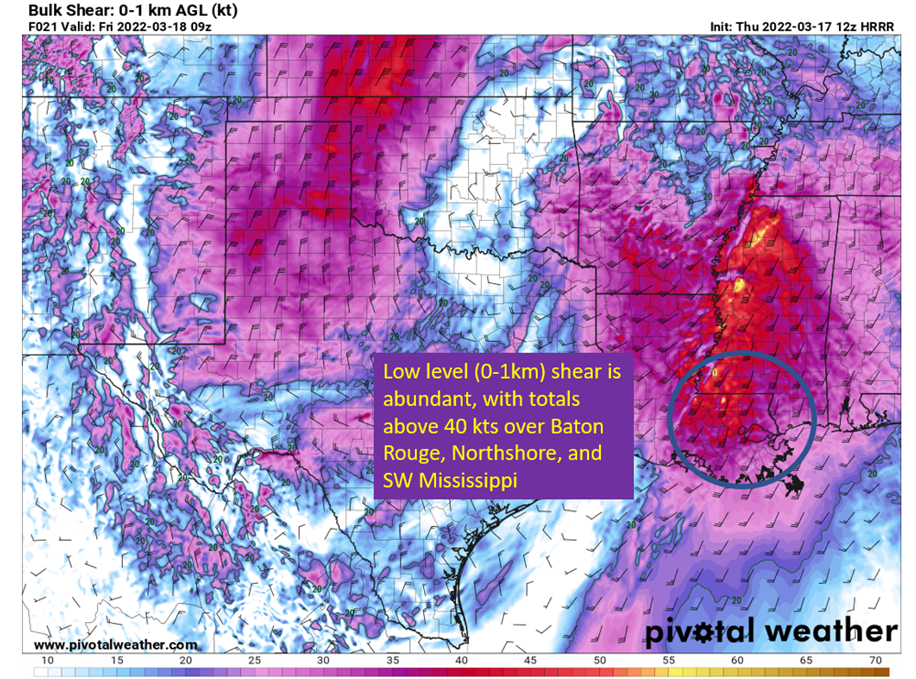
Now to the overnight for southeastern Louisiana and southern Mississippi.


Images taken from pivotalweather from the 12z HRRR. Annotations by Jacob Caddell.
Basically, while the buoyancy from the surface is pretty meager with the low level shear and warm front in place storms could easily overcome that and get rotating updrafts from the surface. So while tornadoes aren’t a certainty over SELA/SWMS, the conditions will exist that could produce a strong tornado if storms get rooted in the surface. Since this is an overnight threat as well, it is vital you have a way to get warnings.
Then toward Mobile, the threat of strong tornadoes is more likely as instability continues to increase ahead of the broken line of storms. It will be near or just after rush-hour. That’s why they’ve got the enhanced risk (3/5) from the SPC. Take a look at the 18z HRRR soundings for around Mandeville at 4 am and Mobile around 8 am.
Mandeville will be on the left and Mobile on the right in the image.

Image made with model soundings taken from pivotalweather.
The short version? Hail and high winds remains the primary risk. There is a conditional risk of strong tornadoes in southeastern Louisiana and southern Mississippi, but it is uncertain how many (if any) materialize. This will be an overnight threat, so have a way to get warnings that will wake you up! Over in Mobile and the Panhandle, there’s a higher likelihood of having tornadoes and potential for them to be strong. It would be wise to also have a way to get warnings and check the radar before you leave for your commute.
That’s all for today.
Related Posts

Hurricane Season 2023 Preview: El Nino Returns

Gulf Low Will Bring Rain and Coastal Flooding

One For The Mardi Gras Skiers

Bust Out The Shorts For Mardi Gras

Hope You’ve Enjoyed Fall So Far. Looking Ahead At The Big Picture Into November.

The Media Coverage Of Ian Has Been Frustrating

Hurricane Ian To Make Second Landfall In Carolinas

Hurricane Ian Strengthens and Grows Larger With Landfall Tomorrow

NHC Forecasting Near Nightmare Scenario For Tampa
