
Severe Weather: New Orleans Thru The Panhandle (3/11/22)
A vigorous longwave through moving east across the plains today will serve to provide a severe threat across the northern Gulf Coast. Questions on instability remain, but there will be abundant shear available to organize storms and it will be increasing through the night. This means the severe threat will increase as you go east. Damaging winds are the obvious threat but could easily get a couple of strong tornadoes in the area south and along warm front.
The timing will see storms move across SELA through the evening, with Baton Rouge getting into the action near 7 pm but they should stay reasonably weak that far west.
Then New Orleans around 9 pm. There is a slight risk (2/5) from the SPC in New Orleans tonight and that is the region I’d expect some severe warnings to start popping up.
Mobile will get into the action around midnight and the system will start to pick up speed.
30A gets into the action about 2 am.
Now let’s take a look at the current surface chart from the WPC to see where the players are.

This is the 18z surface analysis from the Weather Prediction Center on 3/11/22.
A surface low is going to form near the cold front off the coast of Texas and rapidly strengthen into tonight and tomorrow morning, due to the abundant forcing from the incoming longwave trough. That will drag the stationary front up into New Orleans and points eastward as a warm front, bringing near 70 degree dew points with it. A trailing cold front will follow the low pressure as it races off to the NE, providing a focus for linear storms. As the night goes on, low level winds are going to rapidly increase in response to the strengthening low pressure sucking air in, increasing the severe threat as you go east into the central Florida Panhandle and southeastern Alabama and southern Georgia.

The Day 1 categorical outlook from the Storm Prediction Center. @wxliz wrote up the latest SPC discussion and is a great follow on Twitter.
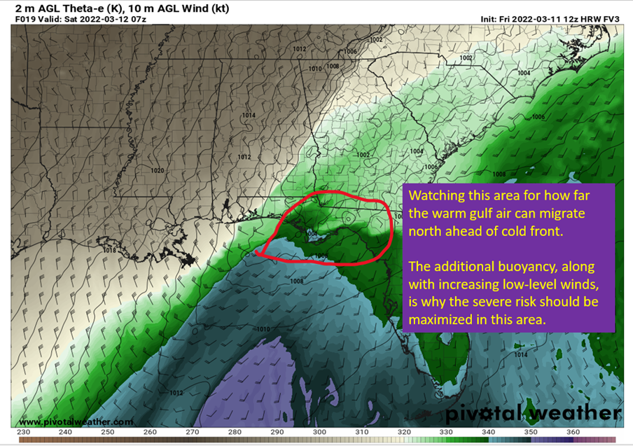
The dynamics are certainly not in question, but there are questions remaining on how far north the Gulf of Mexico moisture gets. Below I show one model solution, showing the central and eastern Panhandle getting the warm air in and less as you get into southern Georgia. We know some will make it inland ahead of the cold front, but how deep it gets remains a little foggy. Further south you are, the more likely it is you get the warm return flow.

Image of theta-e (easiest way to show where the warm moist air is) from the 12z FV3 high-res model. Image source is pivotalweather, with annotations by Jacob Caddell.
This transport of low level warmth northward comes along with the increase in low-level winds mentioned above. Below I have a gif from the 18z HRRR (thanks to the Gif Maker at TropicalTidbits.com), showing the expected rapid strengthening of the surface low pressure and how the low-level winds respond.

Image made at tropicaltidbits.com to show the evolution of the low level winds and how fast they ramp up.
This should also yield a fair bit of severe weather over the low country in South Carolina and far eastern North Carolina tomorrow as the low level shear gets even more impressive with the strengthening low pressure.
Following the severe stuff will be a big shot of cold air for the middle of March. Enjoy the chill y’all, because we’re not likely to get any more like this until next fall. Will be pushing record lows along the central Gulf Coast.
That’s it for today, looking to get another Severe 101 up early next week. Also watching for more severe weather potential early next week.
Related Posts

Hurricane Season 2023 Preview: El Nino Returns

Gulf Low Will Bring Rain and Coastal Flooding

One For The Mardi Gras Skiers

Bust Out The Shorts For Mardi Gras

Hope You’ve Enjoyed Fall So Far. Looking Ahead At The Big Picture Into November.

The Media Coverage Of Ian Has Been Frustrating

Hurricane Ian To Make Second Landfall In Carolinas

Hurricane Ian Strengthens and Grows Larger With Landfall Tomorrow

NHC Forecasting Near Nightmare Scenario For Tampa
