
Severe Threat Shifts East on Wednesday
The active pattern is set to end Wednesday, as a widespread severe risk moves into the Ohio and Mississippi Valleys. Unlike the last couple of days, there won’t be a cap in the way and storms should have no issue firing within a broad warm sector. Of course, with no cap comes questions of convective mode between discrete cells and more linear structures. The SPC has put a moderate risk (4/5) up in the Day 2 outlook for parts of Mississippi, Arkansas, Tennessee, and up into MO and IL. Today, I’m going top down once again to identify the areas of the best forcing and look for limitations on storms. Then I’ll finish, as always, with a model sounding or two to highlight the areas of greatest risk and what those risks will most likely be.
As is tradition, let’s start with the jet stream level.

12z GFS on 4/12/22, showing 300 mb winds and geopotential heights. Image from pivotalweather with annotations by Jacob Caddell.
The upper levels will certainly be supportive tomorrow, which is part of the wide area of threat expected. Up on the northern circle, got a nice divergence and it’s near the right entrance of that northern jet max. On the southern end, we have the jet stream splitting between the subtropical and primary polar jet. This is supportive of vertical motion across both circled regions. Also remember, my images are just for one point in time. These features will be evolving and moving generally east as the day progresses, bringing the severe weather potential with it.
It’s hard to imagine this amplified of a jet stream pattern without a strong 500 mb impulse to go with it. No surprise, it’s there bringing an increase in mid and upper level winds along with height falls (supports storms getting going) across the Mississippi and Ohio Valleys.

The 12z GFS from 4/12/22, showing 500 mb winds and geopotential heights. Image from pivotaleather with annotation by Jacob Caddell.
This punch of strong wind at the 500 mb level increases the bulk shear, which is what supercells and severe thunderstorms want. In addition, heights are going to fall across the region. This means the mid-levels will be cooling and the result is an increase in instability. The best of the 500 mb dynamics are going to be over the Lower Mississippi Valley, generally from the Ark-La-Miss north toward the bootheel of Missouri. This is lining up with the area of upper divergence, and giving even more support to the SPC upgrading the risk across that region this afternoon.
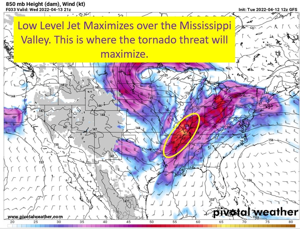
Next, I want to see where the low level winds will be the greatest as that will be the area with the greatest tornado risk tomorrow.

The 12z GFS from 4/12/22, showing 850 mb winds and geopotential heights. Image from pivotalweather with annotations by Jacob Caddell.
This is another one of those snapshot in time situations, as the low level wind max will be shifting east-northeast into the evening. During the afternoon though, it should be located near the Ark-La-Miss and up the Mississippi into Illinois. This will likely mean a linear mode up in Illinois, as the low level shear vector should line up pretty much parallel with the cold front boundary. This promotes cells to quickly merge and grow into a line. Further south, this will be over the open warm sector with the front trailing farther west. With the HRRR favoring broken lines/clusters of cells down toward Ark/Miss/Tenn, that is where the tornado threat will be maximized. No surprise, this is where the SPC is highlighting the greatest tornado risk tomorrow.
Next, to the surface where we can see the warm sector and the incoming cold front.

The 18z HRRR from 4/12/22, showing theta-e (easiest way to visualize where warm and moist air is) and wind barbs. Image from pivotalweather with annotations by Jacob Caddell.
Surface low is up in the Dakotas with another broad area of low pressure generally over Lake Michigan. Cold front extends far to the south into Texas, and will be surface focus to get storms going. There’s an effective warm front up into Illinois and Indiana that should be the northern cut-off for severe potential tomorrow.
There’s a pool of warm moist air from the south of that effective front all the way down to the Gulf Coast to the east of the cold front. This is what I will refer to as the “warm sector”. The highest energy air along the Texas coast into the Ark-La Miss. The dropoff you see in northern Mississippi is due to convection on the model at this point in time. This warm sector will move east over time, ahead of the cold front. The reason to show you this is so you can see how warmth and moisture is co-located over the same areas the low level (850mb) winds are strongest, where the 500 mb heights are falling (which supports storms going up) and strongest winds at that level, and in a location of upper divergence favorable for storms as well.
That’s why the moderate risk area is where it is (will show the SPC map at the bottom of this post).
In terms of timing, I’m going to show a few steps in the 18z HRRR. The general idea is storms will be ongoing over Missouri by the morning and will push into Illinois and western Kentucky over the day. Farther south, there won’t be any storms until early afternoon most likely. When they do finally get going though, the southern storms will have the greatest tornado potential.
Don’t forget though, strong winds and large hail is a threat from Louisiana to Illinois tomorrow. Also potential for flash flooding. I know my focus is mostly on the tornado threat, but I don’t want to completely lose sight of those other risks either.
About 10 am on the HRRR:

The 18z HRRR, showing a depiction of future radar. Image from pivotalweather with annotations by Jacob Caddell.
At 10 am, the HRRR has storms into Missouri and far eastern Oklahoma with a little cell in eastern Texas. This might not be a fully accurate depiction, as there could well be storms pushing across NE Louisiana and Mississippi at this time from a leftover convective system that’s being born in Texas this evening. That’ll be something to watch for, as if there are morning storms into Mississippi that could limit the later severe threat.
Let’s assume there won’t be morning storms though, and follow the model guidance here. In this scenario, instability is building in our warm sector and setting the stage for severe storms as the afternoon goes on.
Now for 1 pm on the HRRR:

The 18z HRRR on 4/12/22. Image from pivotalweather with annotations by Jacob Caddell.
By the early afternoon, storms are still in Missouri along the cold front and starting to fire along the effective warm front shown in the above image depicting frontal placement. At this point, the model is also starting to get convection going in Arkansas and the seeds of storms going in western Louisiana. This storms should mature into the afternoon as they move into the Mid-South where the severe parameters will be at their greatest. Do remember, this might not evolve quite this way as this is just one model depiction. I find the evolution reasonable enough to use as a guideline but don’t take it as a certainty.
Next, we go to 3 pm as storms get firing into Arklamiss and up toward western Tennessee.

The 18z HRRR from 4/12/22. Image from pivotalweather with annotations by Jacob Caddell.
Still with me?
Storms should be forming up into a line along the northern expanse of the threat, though bowing segments and spin-ups within the line will certainly remain a threat.
To the south we have a cluster of small cells running north to south and a discrete cell alone in Arkansas. Don’t focus on exact placement, just that the model wants to fire some discrete cells into a very favorable environment for severe weather. Storm coverage in the south will increase through the afternoon, with all modes of severe weather possible.

The 18z HRRR from 4/12/22. Image from pivotalweather with annotations by Jacob Caddell.
At this point we should have clusters of storms and they should start to try and form a more coherent line. The southern cluster looks rather unorganized, though will still be in a decent spot to support hail and high winds with a tornado not out of the question. Farther north in the middle cluster should have the highest severe risk still, as it will have the best dynamics to work with and not be a straight line like the northern cluster. The northern line could also produce all modes of severe weather, but might struggle for instability with storms going to the south cutting off warm flow.
Finally we have a tail end cell that I want to see if it remains on future runs because that could present a severe threat across southern Louisiana. Just something to watch for, unsure if it happens.
Eventually overnight the cold front will push through the south and lead to a line of storms moving east into Florida and Alabama. Mobile could get some action if the line isn’t quite formed and still made of clusters.
Ok…almost done. Time for a quick look at a sounding and then I’ll sum it up.

A model derived sounding from the HRRR at 18z for a point in western Mississippi tomorrow afternoon. Image from pivotalweather.
Ok, I didn’t draw up anything on this but let’s talk numbers.
Abundant instability with mixed-layer CAPE near 3000 J/kg. This provides upward acceleration of the air from the surface.
The LCL/LFC are both very low, which is correlated with severe storms.
0-1 km shear is over 20 kts, supportive of tornadoes.
0-3 km CAPE is over 200, which again correlates to tornado formation as it provides strong acceleration at the lowest levels.
Steep lapse rates and abundant instability in the hail growth region would support large hail.
In other words, this would support strong tornadoes with high straight line winds and large hail. Hence the moderate risk over the region.

The Day 2 Categorical Outlook from the SPC.
tl;dr version
And it is too long today.
All the ingredients for a severe weather outbreak will be present from Louisiana all the way up the Mississippi River into Illinois and Indiana. Abundant instability and a good shear profile will overrun the enhanced and moderate regions, as a cold front creeps east and creates a surface focus for storms to fire. On the HRRR this afternoon, the storm mode in AR/MS/LA/TN tends to be more discrete and clustered, which leads the southern extent of the moderate risk to have the greatest risk of tornadoes. All across the severe threat will be a risk of strong straight line winds and hail. The hail threat will be most pronounced from northern Mississippi into Illinois and Indiana, but anywhere in the enhanced region could realistically get large hail with the temperature profiles aloft. Storm mode could potentially be more linear though, which would limit the tornado risk somewhat. In addition, will need to watch how far east convection currently in Texas gets by morning as that could take a bite out of the instability on the southern end of things.
It’s a wide area of risk tomorrow. So have a way to get warnings, and take those warnings seriously.
That’s all for today. I’m gonna take tomorrow off and plan to move hosts this weekend and into early next week.
Related Posts

Hurricane Season 2023 Preview: El Nino Returns

Gulf Low Will Bring Rain and Coastal Flooding

One For The Mardi Gras Skiers

Bust Out The Shorts For Mardi Gras

Hope You’ve Enjoyed Fall So Far. Looking Ahead At The Big Picture Into November.

The Media Coverage Of Ian Has Been Frustrating

Hurricane Ian To Make Second Landfall In Carolinas

Hurricane Ian Strengthens and Grows Larger With Landfall Tomorrow

NHC Forecasting Near Nightmare Scenario For Tampa
