
About Next Week
The Gulf Coast got away with minimal impacts this week, but there’s another severe set up to come next week. Right now, we have the plains looking to have a couple of days of risk Tuesday and Wednesday. Thursday will probably have things shift into the Southeast, but there’s still substantial model spread as to exactly where.
At first glance, here on Thursday 4/7, a complicated scenario is emerging for the plains on Monday and Tuesday with complications continuing in figuring out placement for severe threats on Wednesday further east. Details are going to come into better focus as we get into the weekend, but after looking through the modeling this afternoon I just want to take a nap.
Alight, let’s get weird!

The GFS Ensemble mean for the jet stream level winds from 4/7/22 at 12z. Image from tropicaltidbits with the beautiful artwork by Jacob Caddell.
What this is telling me is there is probably going to be multiple waves of threats and potentially separate disturbances on the north and south end as the week gets going. For the first time this year, the Plains actually look to have a severe threat. Don’t worry though, the southeast should eventually get in on the action. Both the GFS and Euro see the southern and northern disturbances but the timing is not aligned between the two. The Euro holds the northern stream energy back until later, which would present a more substantial severe threat on Wednesday across both the southern plains and southeast. The GFS is a little faster with the evolution, but it too would have widespread severe potential but more bust potential as well.

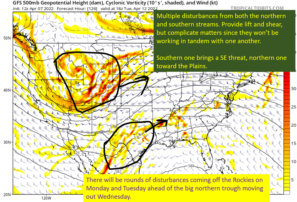
The 12z GFS on 4/7/22, showing 500 mb winds, height, and cyclonic vorticity. Image from tropicaltidbits with annotations by Jacob Caddell.
The general look here is of a longwave trough out over the Rockies. With the subtropical jet where it is, you have shortwaves going around the bottom of the trough. That’s what you see circled into Texas. The northern energy will also have disturbances rotate around the trough base and eject into the plains over Monday and Tuesday. Then the northern energy will finally eject on Wednesday with differences abundant in exactly how amplified it will be, how far south the base will end up, and exactly when it ejects.
Headaches for the forecaster at this point.
I’m not all that interested in looking at model runs for the low-level winds because I know they will pick up in response to the upper level disturbances and the surface low(s) they induce. Since I don’t know exactly how that will evolve, I’m not ready to worry about exact placement. Look below to see the ensemble spread on low pressure position and strength. Clear as mud.

The 12z GEFS from 4/7/22, showing where each ensemble member has the resulting surface low from all this upper level mess and how strong the low is modeled to be.
Big spread. Can’t worry about details on individual model runs yet but I’d like to look at what the general idea would result in each day.
Monday and Tuesday:
The basic story is there will be minor disturbances coming out of the southern Rockies that will provide some lift across the southern plains and central/eastern Texas. Southerly flow will push warm and moist air out of the gulf into Texas and Oklahoma. As the afternoon progresses, a dry line will form and push east. This will provide the surface level forcing to lead to thunderstorm formation. Given the shear and instability that should be there, these storms will have the potential to become severe.
Tuesday would likely get the severe risk farther east, potentially into western Arkansas and Louisiana. Additionally, we will need to watch that southern disturbance as it could bring a severe threat farther south than expectations from the SPC currently, with threats to SE Texas and SW Louisiana. Still very early to lock that in, but something I’m going to be watching for.
Wednesday:
The strong upper low over the Rockies begins to move east, and in response to the forcing from this a strong surface low will form somewhere in the western plains. This low pressure will move NE toward the Upper Mississippi Valley, and will drag a cold front behind it that will stretch all the way to the Gulf Coast. Ahead of this front there will be flow out of the south to continue to push warm air northward and provide a wide swath of instability from the Gulf Coast all the way into Missouri and Iowa. There will be enough shear to support severe weather all across these regions, so the potential for widespread severe weather will be there.
tl;dr version:
The SPC is going to earn their paychecks forecasting this mess. There will be severe potential Monday, Tuesday, and Wednesday at least with potential Thursday as well but very high uncertainty on where and how intense on that part. The threat will not likely get into the southeastern United States until Wednesday, with Texas and Oklahoma enjoying three straight days of threats. On Monday and Tuesday, storms should fire along the dry line in Texas and Oklahoma and progress east into a warm airmass in central and eastern parts of Texas and Oklahoma. On Tuesday there is potential for the threat to materialize further south as well, with SE Texas and SW Louisiana potentially under the gun.
The confidence in a severe outbreak next week is high. The confidence on exactly when and where isn’t.
Related Posts

Hurricane Season 2023 Preview: El Nino Returns

Gulf Low Will Bring Rain and Coastal Flooding

One For The Mardi Gras Skiers

Bust Out The Shorts For Mardi Gras

Hope You’ve Enjoyed Fall So Far. Looking Ahead At The Big Picture Into November.

The Media Coverage Of Ian Has Been Frustrating

Hurricane Ian To Make Second Landfall In Carolinas

Hurricane Ian Strengthens and Grows Larger With Landfall Tomorrow

NHC Forecasting Near Nightmare Scenario For Tampa
