
Wednesday Severe Threat Coming Into Focus
Strong line of storms are expected to move through Louisiana and Mississippi through the late morning and afternoon on Wednesday. The most widespread threat will be damaging winds with strong winds aloft being pulled to the surface in downdrafts, especially where the best surges of dry air aloft will be. I’ll be watching any bowing segments in the line for this. The other threat will be tornadoes, both within the line and within discrete cells and broken segments of the line that could go supercellular. Hail is possible but is the lesser threat compared to the winds and possible tornadoes.
This will be a high shear with limited instability event, which is why I’m skeptical of too many discrete cells firing ahead of the front. Also, the front and associated line of storms will be moving rapidly to the east and limit time any cells could mature before being absorbed into the line.
The last thing of note will be the winds ahead of the line. Even without storms, gusts could easily break 40 mph across the entire area.
The threat will eventually translate into Alabama over the evening hours.

SPC Day 3 Outlook from 3/28/22. The whole region is down a level from the risk of last week, mostly due to the reduced threat of discrete cells in front of the line. Any that do form have a could produce strong to violent tornadoes, but the probabilities appear low at this time.
The first of the convective allowing models, the 3k NAM is in range this afternoon and it’s always worth looking at those to get an idea of storm mode. The NAM paints a mostly linear structure with some breaking of the line to the south and a few shallow showers in front of the line. The broken segments of the line will need watching for some isolated tornado potential if one or two of the cells become dominant. Also, the pressure gradient in front of the line tells me the winds will be strong all day.

The 12z 3km NAM from 3/28/22. Showing simulated radar, surface pressure and 1000-500 mb thickness. Image from pivotalweather, with annotations by Jacob Caddell.
Strong line present entering Mississippi by mid-afternoon on Wednesday. To the south is a more broken structure, that could end up yielding some supercell like structures. It is something to watch, despite the best forcing being a little bit to the north. It is also worth noting those shallow showers out in front. If they could sustain, those could be trouble but there are some reasons to think they will not. There’s a bit of a “cap” (warm air above cooler air) present on the NAM soundings and the instability is not amazing. The NAM does run a little bit on the cold side for temperatures, so with sunlight there might be a little extra instability to work with and maybe enough to overcome any capping.
So while I still expect the treat to remain primarily in the line of storms, there’s enough there to mention the low probability but high impact scenario of a supercell forming out in front.
There should be substantial cloud cover ahead of the front though, which will at least serve to limit instability because if you don’t have the sunlight warming the ground…the ground doesn’t get as warm. I know, groundbreaking stuff!

The 12z 3k NAM from 3/28/22, showing cloud cover on Wednesday afternoon. Image from pivotalweather.
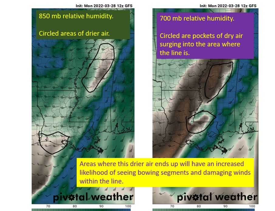
Next I want to take a look at the 850-700 mb humidities and winds. There will likely be pockets of drier air aloft that will get “entrained” into the line of storms. This leads to evaporation, which stabilizes the air aloft and makes it sink and fall in the downdraft. This action can bring the strong winds aloft down to the surface and also helps to accelerate the downdraft a little more. This is why damaging winds within the line are the most likely severe impact here. Below I show the GFS depiction of the 850 and 700 mb relative humidity. Don’t focus on exactly where the slugs of drier air are, just that they are there and are part of the reasoning for concern over strong straight line winds.

RH% at 850 mb (left) and 700 mb (right) from the 12 GFS on 3/28/22. Images cut from pivotalweather and annotated by Jacob Caddell.
As I mentioned yesterday, the upper levels are also going to be favorable for strong storms over Louisiana, Mississippi, and Alabama as there will be another split of the jet stream and prime upper divergence over the region.

GFS from 12z on 3/28/22, showing 300 mb winds. Image from pivotalweather. I circled the area with the upper divergence, though it is not quite as pronounced as last week’s event. This is still enough to give an extra boost to the storms in the region where this split happens.
tl;dr version:
The primary threat with this system will be straight line winds associated with the line of storms that will push through, but imbedded tornadoes are also likely in the line. Out in front there will be an open warm sector, but with the fast moving line and limited instability I expect discrete cells to struggle to mature. It is not impossible, and if one does mature, it will present a significant tornado risk. I am also concerned with the broken line the NAM has in Louisiana, as it is plausible one or two of those could become dominant and present an increased tornado risk. This again strikes me as a low probability, but with higher impact potential so pay attention. Hail is the least likely severe impact with the relative warmth in the column.
Winds in front of the line will also be brisk from the south. I expect widespread 40 mph gust reports across the region ahead of any storms.
Same advice as always. Have multiple ways to get warnings, take those warnings seriously, and hopefully the tornado risk doesn’t materialize outside of the line of storms.
Related Posts

Hurricane Season 2023 Preview: El Nino Returns

Gulf Low Will Bring Rain and Coastal Flooding

One For The Mardi Gras Skiers

Bust Out The Shorts For Mardi Gras

Hope You’ve Enjoyed Fall So Far. Looking Ahead At The Big Picture Into November.

The Media Coverage Of Ian Has Been Frustrating

Hurricane Ian To Make Second Landfall In Carolinas

Hurricane Ian Strengthens and Grows Larger With Landfall Tomorrow

NHC Forecasting Near Nightmare Scenario For Tampa
