
Severe 101(Part 1): What is CAPE?
During severe weather season, we’re looking for two main things. How much potential is there for an updraft to spin (shear) and how much buoyancy is available (instability) to have the air rise. Synoptic scale forcing is another piece of the puzzle but typically if you have a severe weather outbreak…you’ve got the forcing.
CAPE or Convective Available Potential Energy is how meteorologists quantify instability. The larger the number, the more acceleration upward overall.
The idea behind instability is a simple one. Less dense air will rise through denser air, much like the oil settling on the top of a vinaigrette that hasn’t been shaken. Colder air is more dense than warm air, and water vapor is less dense than air. Going back to high school chemistry, you know this. Water is one oxygen and two hydrogens, yielding a molecular weight of 18.02 g/mol and dry air has a molar mass of 28.97 g/mol.
So the more water vapor in your air, the more buoyant that air is.
To stay with the HS chem theme, we can use the ideal gas law to show how temperature effects the density of air.
PV = nRT
Re-arranging and making D = n/V (mass over volume…density) we get:
(P/RT) = D
If we hold Pressure constant and since R is constant, you can see that if you raise the temperature the density will drop.
This is why warm air rises.
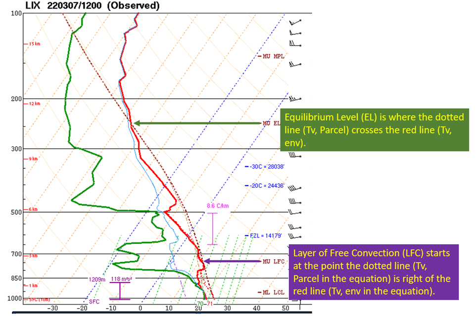
Next, I think it’s helpful to see graphically what CAPE is before looking at the math. I’ve pulled the Birmingham upper air sounding from 4/28/11 at 00z to demonstrate and to show you what scary looks like.

Sounding taken from SPC Archives. Annotations by Jacob Caddell.
The CAPE is the area between the dotted line (hypothetical parcel of air temperature as a result of lifting it up, reducing the pressure, and letting it expand) and the environmental temperature line (red line, which shows the measured temperature of the atmosphere from the surface into the stratosphere). We all know warm air rises, and as long as the parcel is warmer than the environment it will continue to rise.
The points of interest are the Layer of Free Convection (LFC) near the bottom of the column where convection happens uninhibited. This is going to be at or above the Lifted Condensation Level (where the air being raised from the surface becomes saturated, and cools slower due to the phase change from vapor to water pulling energy out without changing the temperature).
The Equilibrium Level (EL): Notice how the parcel temperature eventually crosses the environmental temperature? That’s where the vertical motion will end. In this case, it’s at the tropopause (top of the troposphere, the lowest layer of the atmosphere where our weather happens). You can see that because temperatures start to increase with height in the stratosphere, and that’s where the line eventually crosses.
Mathematically, CAPE is the force caused by the buoyancy differences that is enough to overcome gravity. The greater the number, the faster the air will rise.

The formula for CAPE, taken from Wikipedia.
The subscript on the temperatures can be ignored, for now. It stands for virtual temperature and considers water vapor concentration as well. This is a concept I’ll dive into in a later post.
What this formula is telling you is the difference between the parcel temp and environmental temp is the driving force of convection, and is considered for every point in the vertical direction from the layer of free convection (LFC, or Zf in the formula) and the equilibrium level (EL, or Zn in the formula).
g is the acceleration due to gravity. dz just tells you to do the math from the bottom point to the top point. Sum it together (or, in other words, to find the area under the curve) and you have the potential energy of convection lifting the parcel over the entire area in question.
Finally, when I think about what is “high CAPE” or “low CAPE” I have ranges in my head:
Low: 0-1000 J/kg
Medium: 1000 – 2500 J/kg
High: 2500-4000 J/kg
Extreme: > 4000 J/kg
That’s all for this edition of Severe Weather 101. Next time, I’ll discuss the virtual temperature and how it is used and the differences between “fat” and “skinny” CAPE.
Related Posts

Hurricane Season 2023 Preview: El Nino Returns

Gulf Low Will Bring Rain and Coastal Flooding

One For The Mardi Gras Skiers

Bust Out The Shorts For Mardi Gras

Hope You’ve Enjoyed Fall So Far. Looking Ahead At The Big Picture Into November.

The Media Coverage Of Ian Has Been Frustrating

Hurricane Ian To Make Second Landfall In Carolinas

Hurricane Ian Strengthens and Grows Larger With Landfall Tomorrow

NHC Forecasting Near Nightmare Scenario For Tampa
