
Workweek Preview: 2/7- 2/11 and First Look Carnival Season Forecast
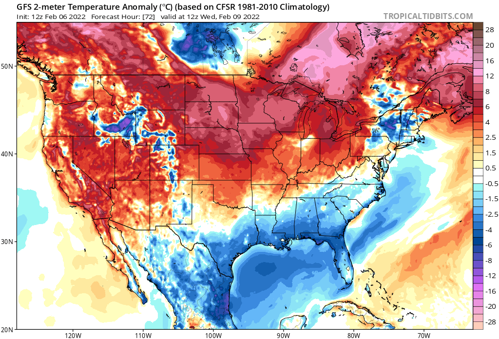

Image From Tropical Tidbits. Showing below average temperatures for the Northern Gulf Coast on Wednesday. This will be the trend until the end of the week, with mostly blue skies and cool temperatures. Enjoy it because we all know the heat will be back soon enough.
The workweek forecast is going to be very straightforward this week.
We will see a continuation of the troughing (colder) in the east and ridging in the west (warmer), but unlike last week Louisiana over to 30-A will be on the side with sinking air. Additionally, this means flow will be out of the north and northwest for the extent of the week and that means drier air being moved in. This is a recipe for one of those magical weeks of Gulf Coast weather where it’s both cool and sunny.
In New Orleans, temps will remain in the mid 50s for highs and mid 40s for lows until the middle of the week when some moderation up to the lower 60s is expected.
Forecast Highs From The NWS Numerical Model Blend (NMB) on 2/6 at 18z (NOLA Lakefront): M: 52, Tu : 53, W: 59, Th: 61, F: 62
Interestingly enough, North of the Lake should see warmer temperatures for most of the week, thanks to that NW flow blowing over the cool lake water to keep New Orleans cooler.
Baton Rouge Highs from the NWS NMB: M: 56, Tu: 59, W: 64, Th: 67, F: 67
Summary: This will be one of the best weather weeks of the entire year, with no rain and cool temperatures. There may be some clouds Monday as a small system moves in, but it will not have enough moisture to produce rain. Otherwise, picture perfect weather.

Image From Tropical Tidbits. Annotations by Jacob Caddell
Now looking forward to Carnival Season, the forecast is as clear as mud.
Take a look at the image below, showing 500 mb heights over the Northern Pacific. I boxed the area of focus, as the pattern turn to a warmer regime will require the ridge (red colors) currently sitting right off the Pacific coast to slide westward toward the Bering Sea. As you’ll see in the attached gif, storms coming off Asia strengthen and start to build the ridge downstream of them, leading to the northern Pacific ridge to make that move west. Now when exactly this happens is still a question, but this change is part of why the Super Weekend and Lundi/Mardi Gras ought to be a little warmer than normal.
And remember, below is just a model run, just using it to show how the action over the Pacific would lead to a change in pattern over the United States.

Image Source: Tropical Tidbits. Annotations by Jacob Caddell

Image made through the Forecast Gif maker on Tropical Tidbits.
You can see the consequences of the building ridge westward by the end, with lower heights (colder air) dominating the west and heights increasing in the east.
The next piece is to check the polar vortex.
A point of clarity: The polar vortex (PV) is just the circulation around the pole (in our case, North Pole). It is how strong the circulation is that matters, as a weaker circulation allows more cold air to spill from the poles to the mid-latitudes and a stronger vortex will tend to keep the coldest air pinned up north. Currently we have a pretty weak but strengthening PV, and it has allowed cold to spill into the eastern United States for the better part of two weeks now. That looks to be changing; however, as temperatures in the stratosphere continue to cool and this tends to strengthen the vortex.
Below is the AO (Arctic Oscillation) forecast, with positive values showing a stronger PV. It is currently a bit positive and the forecast only has it strengthening by the middle of the month.

Image Source: The Climate Prediction Center (CPC) at NOAA
This is another data point to suggest a warmer than normal set up at Mardi Gras.
Right now, I think the weekend before the main week of parades will be seasonal in terms of temperatures with the pattern change not quite in place yet. I’m still of the mind the main weekend of parades ends up warmer than normal, and with the temperature changes and troughing in the west would present severe weather potential that week too. This is a very low confidence forecast at this point though, as models continue to want to keep some colder air around. The last week of the year still isn’t in ensemble range either, and as it comes into range I’ll have a better idea if this idea is going to actually play out.
That’s all for today. I’ll preview next weekend in the coming days, along with another Carnival Season update.
Related Posts

Hurricane Season 2023 Preview: El Nino Returns

Gulf Low Will Bring Rain and Coastal Flooding

One For The Mardi Gras Skiers

Bust Out The Shorts For Mardi Gras

Hope You’ve Enjoyed Fall So Far. Looking Ahead At The Big Picture Into November.

The Media Coverage Of Ian Has Been Frustrating

Hurricane Ian To Make Second Landfall In Carolinas

Hurricane Ian Strengthens and Grows Larger With Landfall Tomorrow

NHC Forecasting Near Nightmare Scenario For Tampa
