
Easter Sunday: Louisiana Large Hail Risk
Once again I’m here to warn you about severe weather in the deep south.
April continues to provide a bounty of shear and instability fueling round and round of severe potential. The SPC has upgraded the risk to enhanced (3/5) across a good portion of the I20 corridor in Louisiana and Mississippi. The risk moves south too, toward the Florida Parishes as the evening goes on. The primary threat with this is hail, with weak low-level shear but strong shear aloft favoring hail vs a tornado risk.
Going to do a quick look at the upper levels, highlighting a favorable jet stream position and incoming shortwave trough (makes lift). Then looking at the equivalent temperature (puts moisture and temperature into one number) we can see how the convective complex should move SE over the evening bringing the severe threat with it.
The severe potential should be a little less as it gets toward I12, with the best focus shifting to the east as the evening goes on. Still have to keep an eye on it for Baton Rouge and the Northshore. New Orleans metro could get into some of it as well, but the risk currently looks to be lower still vs locations near I12.
First off, going to look at the GFS depiction of the upper level winds.

Above image showing the 12z GFS from 4/17/22, depicting 300 mb winds. Image from pivotalweather with annotations by Jacob Caddell.
This jet stream positioning promotes rising air, despite being on the “cold” side of the jet. The strength of the jet stream winds is due to the temperature gradient aloft; therefore, as the winds increase in the jet air will rise on the cold side to cool even more and sink on the warm side to warm that end even more. End result is the left exit region is favorable for thunderstorm development. Plus you have the obvious divergence aloft from the splitting jet.
Next, there’s a little shortwave coming across the southern Plains into the Mississippi Valley. Take a look at the 500 mb depiction from this afternoon’s GFS below.

Above image is from the 12z GFS on 4/17/22, depicting the 500 mb geopotential heights and winds. Image is from pivotalweather with notations by Jacob Caddell.
This part is straightforward. Just to the right of the base of the trough you have flow that helps produce upward motion which helps storms form. In addition, the stronger winds at this level will help produce strong shear in the upper levels. This is where the outflow happens, helping to vent the storms and is a piece that supports the large hail risk.
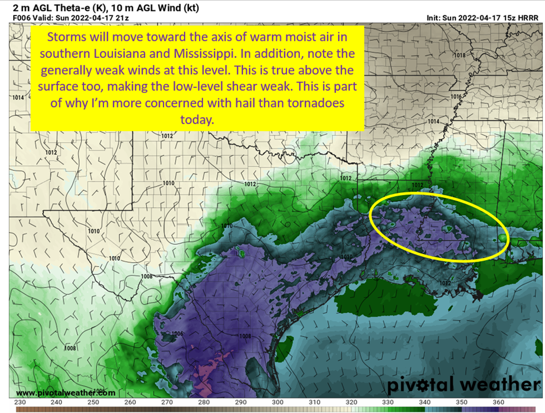
Moving on, I want to look at the warm moist air at the surface as this will be the direction storms move toward as the evening progresses.

The above image is from the 15z HRRR from 4/17/22, depicting theta-e (warm moist air) at the surface and the wind at the surface. Image from pivotalweather with annotations by Jacob Caddell.
The convective structure that should form in northern Louisiana and central Mississippi this afternoon will tend to move toward this axis of warm air. The cold air being dropped in the downdrafts will push out and lift the warm air in front, this will lift the warm air, and the process will continue.
Finally, I’m going to show you a forecast sounding off the HRRR to help explain why hail is the biggest risk today.

The above is a forecast sounding from the 15z HRRR, for a location near Alexandria, LA around 4 pm central this afternoon. Image is from pivotalweather with annotations by Jacob Caddell.
You might wonder why weak low-level shear is actually helpful for hail growth. This idea has been pointed out by Cameron Nixon quite a bit lately and it makes a lot of sense. Hail growth depends on residence time, which just means how long the growing hail is held in the hail growth region (between -10 and -30 Celsius). Strong shear in the low levels promotes a stronger updraft that will often lift the hail straight through the growth region too quickly. The weaker shear in the inflow tends to have slower upward acceleration and holds the hail in the growth region longer. This coupled with the high outflow shear aloft leads to further increasing the residence time.
All of this together leads to concern for large hail today. In addition, the drier air in that 850-500 mb range will help support strong downdrafts and a straightline wind threat. Tornado risk appears low, since there is not much shear to get the low level updraft spinning. It is a non-zero risk though because there is good instability in the low levels and the stretching of the inflow can lead to additional spin and tornadoes to be produced. They aren’t likely to be long lived though.

tl;dr version
Storms should fire in northern Louisiana this afternoon and present a threat of large hail. These storms will eventually cluster up and start pushing south toward the warmth near the coast as the cold outflow pushes into that warm air, lifts it up and continues the storm producing process. The greatest threat is large hail, with straightline winds secondary, and a small risk of tornadoes. The risk is going to be greatest in northern Louisiana and into southern Mississippi and eventually down toward I12. The risk will also shift east as the evening progresses toward southern Alabama. New Orleans is in the margins as the timing of storms trying to cross the Lake will be when the best dynamics shift toward Alabama.
Just be weather aware this afternoon, and have a happy Easter (hopefully without hail coming to sour the day).
Related Posts

Hurricane Season 2023 Preview: El Nino Returns

Gulf Low Will Bring Rain and Coastal Flooding

One For The Mardi Gras Skiers

Bust Out The Shorts For Mardi Gras

Hope You’ve Enjoyed Fall So Far. Looking Ahead At The Big Picture Into November.

The Media Coverage Of Ian Has Been Frustrating

Hurricane Ian To Make Second Landfall In Carolinas

Hurricane Ian Strengthens and Grows Larger With Landfall Tomorrow

NHC Forecasting Near Nightmare Scenario For Tampa
