Wait? No Storms In The Southeast This Week?
The wave of severe threats every Tuesday and Wednesday ends this week. Good news.
The bad news? High pressure is going to remind us Summer is just around the corner.
At least the dew points won’t be summertime aggressive just yet.

High Pressure Takes Over
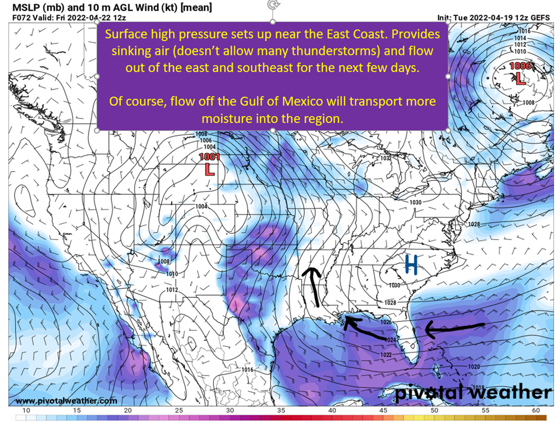
While it is very pleasant today over most of the Southeast, a building ridge of high pressure both at the surface and aloft will start a warm-up through the weekend. While it will keep a lid on rainfall chances until Sunday for Louisiana, it also means sunny skies with the high sun angle of late April. The result will be temperatures increasing to the mid-80s by the weekend. In addition, winds will remain out of the east and southeast over the next five days which will push moist air off the Gulf of Mexico and Atlantic Ocean into the Southeast.
It won’t be full on summer, but the first good reminder that those 90 degree humid days aren’t that far away.

Upper Levels Reinforce the Warming
Jet stream gets pushed north toward Canada in the eastern United States, leaving a deep pocket of warmer air to the south. Down at the 500 mb level, a ridge will situate its self over the Southeast providing more forcing to have air sink and showing this will be a warmer airmass over us. Really going to feel like late Spring this weekend.
There’s a big trough expected out over the western USA, and this will also serve to strengthen the ridge some downstream. There are differences in modeling of how this interaction will take place, with the GEFS being the weakest of these solutions. European ensembles have a bit more amplification of the patter (deeper trough/stronger ridge downstream). A stronger ridge will have consequences going into next week in terms of when a front and rain chances return.
For this weekend though, this overall pattern should keep us dry and warm. Next up, let’s look at where the weather will be active this week.

Severe Weather In The Plains. Rain For The Arkansas and Middle Mississippi Valleys.
It is still April though, so you know there will be active weather somewhere.
Oklahoma Today
Slight risk on the board for the next few days, starting today in eastern Oklahoma. Uncertainty remains concerning how many storms are able to fire and mature through the region, but ingredients are there ahead of the dryline for a few tornadoes and large hail if storms do mature.

Rain Ahead For Arkansas, Missouri, and Iowa
With the southeastern ridge in place and a large longwave trough in the west, there will be a path for small disturbances to round the base of the trough and run north around the southeastern ridge. This will give additional rounds of severe weather for the Plains through the weekend and bring near constant rain chances for Arkansas, Oklahoma, Missouri, Iowa, and Illinois.

tl;dr version
Summer makes it’s first push into the Southeast this weekend, with highs into the upper 80s and dew points increasing to near 70. Not full on summer, thankfully, just a little taste. Does mean a rain-free French Quarter Fest in New Orleans and a nice weekend to get out across the rest of the South. Farther northwest, there will be severe potential in the Plains through the weekend and rain for OK, AR, MO, IL, and IA to go along with it.
So bring the sunscreen, get those shorts out, and enjoy a warm and sunny late spring end of the week and weekend down in the Southeast.
Later this week, I’m going to have another addition of Severe 101 with a second piece on the hodographs. After that, I also will look at the changing El Nino/La Nina forecast for hurricane season (you’re going to hate it) and preview the weather for early next week.